Puno Region

Last updated
Puno Region
Titicaca-isola.jpg
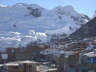
Lake Titicaca, which is partly located in the Puno Region
Primer-lugar-de-la-bandera-regional-Puno1.jpg
Flag
Escudo regional Puno.png
Seal
Peru - Puno Department (locator map).svg
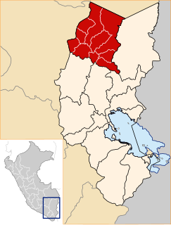
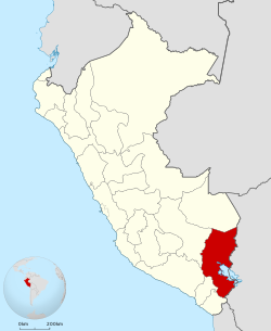
Location of the Puno Region in Peru
Coordinates: 15°04′S70°07′W / 15.07°S 70.12°W / -15.07; -70.12 Coordinates: 15°04′S70°07′W / 15.07°S 70.12°W / -15.07; -70.12
Country Peru
Subdivisions13 provinces and 108 districts
Capital Puno (138000)
Government
  GovernorWalter Aduviri Calisaya
(2019–2022)
Area
  Total66,997 km2 (25,868 sq mi)
Population
(2017)
  Total1,172,697
  Density18/km2 (45/sq mi)
UBIGEO
21
Dialing code 0+51
ISO 3166 code PE-PUN
Principal resources Quinoa; it is also the nation's largest producer of potatoes, sheep, alpacas and llamas.
Poverty rate60.8% (INEI 2009)
Percentage of Peru's GDP 2.3%
Website www.regionpuno.gob.pe

Puno (Spanish pronunciation:  [ˈpuno] ) is a region in southeastern Peru. It is bordered by Bolivia on the east, the regions of Madre de Dios on the north, Cusco and Arequipa on the west, Moquegua on the southwest, and Tacna on the south. Its capital is the city of Puno, which is located on Lake Titicaca in the geographical region known as the Altiplano or high sierra.

Regions of Peru first level administrative subdivision of Peru

The regions of Peru are the first-level administrative subdivisions of Peru. Since its 1821 independence, Peru had been divided into departments but faced the problem of an increasing centralization of political and economic power in its capital, Lima. After several unsuccessful decentralization attempts, the legal figure of region became official and regional governments were elected to manage the departments on November 20, 2002, until their planned fusion into real regions.

Peru republic in South America

Peru, officially the Republic of Peru, is a country in western South America. It is bordered in the north by Ecuador and Colombia, in the east by Brazil, in the southeast by Bolivia, in the south by Chile, and in the west by the Pacific Ocean. Peru is a megadiverse country with habitats ranging from the arid plains of the Pacific coastal region in the west to the peaks of the Andes mountains vertically extending from the north to the southeast of the country to the tropical Amazon Basin rainforest in the east with the Amazon river.

Bolivia country in South America

Bolivia, officially the Plurinational State of Bolivia is a landlocked country located in western-central South America. The capital is Sucre while the seat of government and financial center is located in La Paz. The largest city and principal industrial center is Santa Cruz de la Sierra, located on the Llanos Orientales a mostly flat region in the east of Bolivia.

Contents

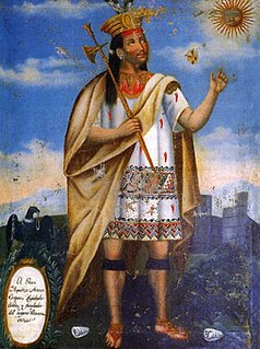
Puno was the territory of the Tiahuanacos (800 A.D. – 1200 A.D.), who were the highest cultural expression of the Aymara people who established themselves in what is today Peru and Bolivia. The Incas took over these lands in the fifteenth century, and the Spanish, attracted by the mining industry developed there, left an important Colonial legacy throughout the entire area.

Tiwanaku empire Pre-Columbian polity based in the city of Tiwanaku in western Bolivia that extended around Lake Titicaca and into present-day Peru and Chile from 300 to 1150

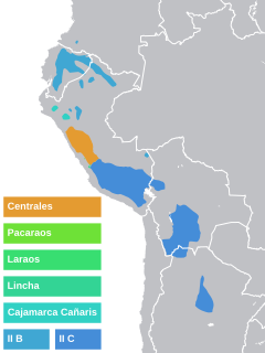
The Tiwanaku state was a Pre-Columbian polity in western Bolivia based in the southern Lake Titicaca Basin. Tiwanaku was one of the most significant Andean civilizations. Its influence extended into present-day Peru and Chile and lasted from around AD 550 to 1000. Its capital was the monumental city of Tiwanaku, located at the center of the state's core area in the southern Lake Titicaca Basin. This area has clear evidence for large-scale agricultural production on raised fields that probably supported the urban population of the capital. Researchers debate whether these fields were administered by a bureaucratic state (top-down) or through collaboration of a segmented state or federation with local autonomy. One obsolete theory suggests that Tiwanaku was an expansive military empire, based on comparisons to the later Inca Empire, but supporting evidence is weak.

Geography

The Puno Region is located in the Collao Plateau. The western part of Lake Titicaca, which is the world's highest navigable lake, is located in the department. The Andean mountains make up 70% of the region's territory, and the rest is covered by the Amazon rainforest.

Altiplano plateau

The Altiplano, Collao, Andean Plateau or Bolivian Plateau, in west-central South America, is the area where the Andes are the widest. It is the most extensive area of high plateau on Earth outside Tibet. The bulk of the Altiplano lies in Bolivia, but its northern parts lie in Peru, and its southern parts lie in Chile and Argentina.

Lake Titicaca lake in Peru and Bolivia

Titicaca is a large, deep lake in the Andes on the border of Bolivia and Peru, often called the "highest navigable lake" in the world. By volume of water and by surface area, it is the largest lake in South America. Lake Maracaibo has a larger surface area, but it is a tidal bay, not a lake.

Andes Mountain range in South America

The Andes or Andean Mountains are the longest continental mountain range in the world, forming a continuous highland along the western edge of South America. This range is about 7,000 km (4,300 mi) long, about 200 to 700 km wide, and of an average height of about 4,000 m (13,000 ft). The Andes extend from north to south through seven South American countries: Venezuela, Colombia, Ecuador, Peru, Bolivia, Chile and Argentina.

The lake contains numerous islands whose inhabitants continue to live as their ancestors have in custom and tradition. The Uros an example of this; this people group lives on "floating islands" that they have artificially made entirely of totora reeds, and they navigate in their traditional boats also made out of totora reeds. Taquile, Suasi, and Amantaní are known for their kindness of their residents, their ancestral skill in weaving, their pre-Columbian constructions, and lovely countryside. The Titicaca National Reserve (36,180 hectares) protects extensive stretches of totora reeds and various species of plants and animals.

The climate is cold and dry, with a four-month rain season. On the other hand, the climate of the rainforest is warm. The water resources are taken from the Lake Titicaca, 50 lagoons and more than 300 rivers. There is also an important potential in underground waters.

Political division

The region is divided into 13 provinces (provincias, singular: provincia), which are composed of 107 districts (distritos, singular: distrito). The provinces, with their capitals in parentheses, are:

Azángaro Province Province in Puno, Peru

Azángaro Province is a province of the Puno Region in Peru.

Carabaya Province Province in Puno, Peru

Carabaya Province is a province of the Puno Region in the southern part of Peru. It is bounded on the north by the Madre de Dios Region, on the east by the Sandia Province, on the south by the provinces of Azángaro, Melgar and Putina and on the west by the Cusco Region. The capital of the province is the city of Macusani.

Macusani Town in Puno, Peru

Macusani is a town in Southern Peru, capital of the province Carabaya in the region Puno.

History

In ancient times, the Collao plateau was inhabited by Aymara groups (Collas or Qolla, Zapanas, Kallahuayos and Lupacas). The Quechuas came later.

Aymara people ethnic group

The Aymara or Aimara people are an indigenous nation in the Andes and Altiplano regions of South America; about 1 million live in Bolivia, Peru and Chile. Their ancestors lived in the region for many centuries before becoming a subject people of the Inca in the late 15th or early 16th century, and later of the Spanish in the 16th century. With the Spanish American Wars of Independence (1810–25), the Aymaras became subjects of the new nations of Bolivia and Peru. After the War of the Pacific (1879–83), Chile annexed territory occupied by the Aymaras.

Lupaca

The Lupaca, Lupaka, or Lupaqa people were one of the divisions of the ancestral Aymaras. The Lupaca lived for many centuries near Lake Titicaca in Peru and their lands possibly extended into Bolivia. The Lupacas and other Aymara peoples formed powerful kingdoms after the collapse of Tihuanaco in the 11th century. In the mid 15th century they were conquered by the Inca Empire and in the 1530s came under the control of the Spanish Empire.

According to chronicler Inca Garcilaso de la Vega, these ancient times coincide with the legend of Manco Cápac and Mama Ocllo, who emerged from the waters of Lake Titicaca to found the Inca Empire.

Inca Garcilaso de la Vega Spanish chronicler

Inca Garcilaso de la Vega, born Gómez Suárez de Figueroa and known as El Inca or Inca Garcilaso de la Vega, was a chronicler and writer born in the Spanish Empire's Viceroyalty of Peru. He is considered the first biological mestizo (mixed-race) person in the history of America. Sailing to Spain at 21, he was educated informally there, where he lived and worked the rest of his life. The natural son of a Spanish conquistador and an Inca noblewoman born in the early years of the conquest, he is known primarily for his chronicles of Inca history, culture, and society. His work was widely read in Europe, influential and well received. It was the first literature by an author born in the Americas to enter the western canon.

Manco Cápac first Sapa Inca of the Kingdom of Cusco

Manco Cápac, also known as Manco Inca and Ayar Manco was, according to some historians, the first governor and founder of the Inca civilization in Cusco, possibly in the early 13th century. He is also a main figure of Inca mythology, being the protagonist of the two best known legends about the origin of the Inca, both of them connecting him to the foundation of Cusco. His main wife was Mama Uqllu, also mother of his son and successor Sinchi Ruq'a. Even though his figure is mentioned in several chronicles, his actual existence remains unclear.

Mama Ocllo deity

In Inca mythology, Mama Ocllo was deified as a mother and fertility goddess. In one legend she was a daughter of Inti and Mama Killa, and in another the daughter of Viracocha (Wiraqucha) and Mama Qucha. In all of them she was the sister and wife of Manco Cápac, whom she established the city of Cusco with. In some variations, she also had a son, Sinchi Roca, with him, though all Incan rulers after Manco Cápac were believed to be their descendants.

The Aymara culture, also known as Putina, was the most important and influential pre-Hispanic culture in the region.

During the Viceroyship, Puno was the obliged route for travelers going to Potosí, Bolivia. In 1668, viceroy Conde de Lemos established San Juan Bautista de Puno as the capital of the province of Paucarcolla. Later, it was called San Carlos de Puno, in honor of the ruling king, Charles II of Spain.

In 1870, the railway route Arequipa-Puno was installed and navigation in Lake Titicaca started.

In 2007, a meteorite landed in the region, triggering a widespread illness amongst the locals. The exact cause of the illness is unknown, but is speculated to be a result of arsenic or other toxic chemicals that may have been released by the heat of impact.

Language and ethnicity

Indigenous people are the majority in the Puno region. As of 2011, 41.4% of Puno's inhabitants speak Quechua, 30.39% speak Aymara; 0.05% speak Ashaninka; and 0.03% speak another indigenous language. Monolingual Spanish speakers make up 28.1% of the population. [1]

According to the 2007 Peru Census, the language learnt first by most of the residents was Quechua (38.01%) followed by Spanish (34.81%) and Aymara (26.93%). The Quechua variety spoken in Puno is Cusco–Collao Quechua. The following table shows the results concerning the language learnt first in the Puno Region by province: [2]

ProvinceQuechuaAymara Asháninka Another native languageSpanishForeign languageDeaf or muteTotal
Azángaro104,4563641213623,7596172128,905
Carabaya57,70342662310,385143968,596
Chucuito67386,3051703331,9648127119,280
El Collao50359,3471161717,50517877,567
Huancane20,40035,249321110,39259366,182
Lampa34,08516871311,357166845,714
Melgar49,65516341320,479136570,392
Moho14622,5924133,624-4126,447
Puno60,26157,7161193798,875625166217,799
Putina28,5374,439152414,32813947,383
San Román67,74619,3994860139,85040176227,319
Sandia31,3996,11714420,70245758,297
Yunguyo25230,691571814,177103245,237
Total455,816322,976641392417,3977431,1531,199,118
%38.0126.930.050.0334.810.060.10100.00

Tourism

Uros Floating Islands in Puno. Los Uros en Puno.jpg
Uros Floating Islands in Puno.
Suasi Island. Isla Suasi PUNO-PERU.jpg
Suasi Island.

Tourism is currently expanding in the Puno Region, with several tour operators and hotels ranging from low budget hostels to high-end hotels.

Related Research Articles

Juliaca Place in Puno, Peru

Juliaca is the capital of San Roman Province in the Puno Region of southeastern Peru. It is the region's largest city with a population of 276,110 inhabitants (2017). On the Altiplano, Juliaca is 3,825 metres (12,549 ft) above sea level, is located on the Collao Plateau and is northwest of Lake Titicaca (45 km). It is the largest trade center in the Puno region.

Department of Arequipa Region in 8 provinces and 109 districts, Peru

Arequipa is a department in southwestern Peru. It is bordered by the departments of Ica, Ayacucho, Apurímac and Cusco in the north, the Department of Puno in the east, the Department of Moquegua in the south, and the Pacific Ocean in the west. Its capital, also called Arequipa, is Peru's second-largest city.

Cuzco Department Region in 13 provinces and 108 districts, Peru

Cusco, also spelled Cuzco, is a department in Peru. It is bordered by the departments of Ucayali on the north; Madre de Dios and Puno on the east; Arequipa on the south; and Apurímac, Ayacucho and Junín on the west. Its capital is Cusco, the capital of the Inca Empire.

Arequipa Province Province in Arequipa, Peru

Arequipa is a province in the Arequipa Region, Peru. Its capital, Arequipa, is Peru's third most populous province of Peru. It borders the provinces of Islay, Camaná, Caylloma, and the Cusco and Puno regions. According to INEI in the year 2014 it has a population of 958.351 people.

Puno Province Province in Puno, Peru

Puno is a province in the Puno Region, in southeastern Peru. It borders the provinces of Huancane, San Román, El Collao and the Moquegua Region's province of General Sánchez Cerro. Its capital is the city of Puno, which is located at the edge of Lake Titicaca, the world's highest navigable lake. It is the economic powerhouse of the region.

San Román Province Province in Puno, Peru

San Román is a province in the Puno Region of Peru. It borders the provinces of Lampa, Azángaro, Puno, Huancane, the Arequipa Province of the Arequipa Region and Moquegua Region's province of General Sánchez Cerro. Its capital is the city of Juliaca which is also second-largest city of the region.

Cusco–Collao or Qusqu–Qullaw (Quechua) is a collective term used for Quechua dialects that have aspirated and ejective plosives, apparently borrowed from Aymaran languages. They include Cusco Quechua, Puno Quechua, North Bolivian Quechua, and South Bolivian Quechua. Together with Ayacucho Quechua, which is mutually intelligible, they form the Southern Quechua language.

Southern Quechua language family

Southern Quechua, or simply Quechua, is the most widely spoken of the major regional groupings of mutually intelligible dialects within the Quechua language family, with about 6.9 million speakers. It is also the most widely spoken indigenous language in the entire New World. The term Southern Quechua refers to the Quechuan varieties spoken in regions of the Andes south of a line roughly east–west between the cities of Huancayo and Huancavelica in central Peru. It includes the Quechua varieties spoken in the regions of Ayacucho, Cusco and Puno in Peru, in much of Bolivia and parts of north-west Argentina. The most widely spoken varieties are Cusco, Ayacucho, Puno (Collao), and South Bolivian.

Huancané Province Province in Puno, Peru

Huancané Province is a province of the Puno Region in Peru. The capital of the province is the city of Huancané.

San Antonio de Putina Province Province in Puno, Peru

San Antonio de Putina Province is a province of the Puno Region in Peru.

San José District is one of fifteen districts of the Azángaro Province in Peru.

Huatasani District is one of eight districts of the province Huancané in Peru.

Lake Loriscota or LakeLorisccota is a lake in Peru. It is situated in the Puno Region, El Collao Province, Santa Rosa District.

Wila Quta or Wilaquta may refer to:

Pukara means a ruin of the fortifications made by the natives of the central Andean cultures.

Pukara, Puno

Pukara, Puno is a town in the Puno Region, Lampa Province, Pucará District, Peru. It is located to the north-west of Lake Titicaca.

Tupu Inka is an archaeological site in Peru. It is located in the Puno Region, Yunguyo Province, Unicachi District.

Yuraq Apachita may refer to:

Colla Kingdom

The Colla, Qolla or Qulla Kingdom was established in the northwestern basin of the Titicaca, one of the Aymara kingdoms that occupied part of the Collao plateau after the fall of Tiwanaku. In the mid-15th century the Collas possessed a vast territory, one of the largest of the Aymara kingdoms, which at the time the 9th Sapan Inka Pachakutiq Yupanqui Qhapaq the Intipchurin, conquered along with other political entities in the region.

References

  1. Blanco Gallegos, Melanie (2011-03-11). "Quechuas se impondrán ante los aymaras en elecciones del 10 de abril". Los Andes. Puno. Retrieved 2011-07-16.
  2. inei.gob.pe Archived 2013-01-27 at the Wayback Machine INEI, Peru, Censos Nacionales 2007