Loreto Region

Last updated
Loreto Region
Iquitos et l'Amazonie 979.jpg
Iquitos
Bandera Region Loreto.png
Flag
Escudo Region Loreto.png
Seal
Peru - Loreto Department (locator map).svg
Location of the Loreto Region in Peru
Coordinates: 4°00′S74°19′W / 4.0°S 74.32°W / -4.0; -74.32 Coordinates: 4°00′S74°19′W / 4.0°S 74.32°W / -4.0; -74.32
Country Peru
Subdivisions7 provinces and 51 districts
Capital Iquitos
Government
  GovernorElisbán Ochoa
(2019–2022)
Area
  Total368,851.95 km2 (142,414.53 sq mi)
Highest elevation
220 m (720 ft)
Lowest elevation
70 m (230 ft)
Population
(2017)
  Total883,510
  Density2.4/km2 (6.2/sq mi)
UBIGEO
16
Dialing code 065
ISO 3166 code PE-LOR
Principal resources Rice, cassava, wood, fruit trees, rubber and cebu cattle
Poverty rate70%
Percentage of Peru's GDP 2.51%
Website www.regionloreto.gob.pe

Loreto (Spanish pronunciation:  [loˈɾeto] ) is Peru's northernmost region. Covering almost one-third of Peru's territory, Loreto is by far the nation's largest department; it is also one of the most sparsely populated regions due to its remote location in the Amazon Rainforest. Its capital is Iquitos.

Peru republic in South America

Peru, officially the Republic of Peru, is a country in western South America. It is bordered in the north by Ecuador and Colombia, in the east by Brazil, in the southeast by Bolivia, in the south by Chile, and in the west by the Pacific Ocean. Peru is a megadiverse country with habitats ranging from the arid plains of the Pacific coastal region in the west to the peaks of the Andes mountains vertically extending from the north to the southeast of the country to the tropical Amazon Basin rainforest in the east with the Amazon river.

Regions of Peru first level administrative subdivision of Peru

The regions of Peru are the first-level administrative subdivisions of Peru. Since its 1821 independence, Peru had been divided into departments but faced the problem of an increasing centralization of political and economic power in its capital, Lima. After several unsuccessful decentralization attempts, the legal figure of region became official and regional governments were elected to manage the departments on November 20, 2002, until their planned fusion into real regions.

Iquitos City in Loreto, Peru

Iquitos, also known as City of Iquitos, is the capital city of Peru's Maynas Province and Loreto Region. The largest metropolis in the Peruvian Amazon, east of the Andes, it is the ninth most populous city of Peru.

Contents

Boundaries

Ecuador Republic in South America

Ecuador, officially the Republic of Ecuador, is a country in northwestern South America, bordered by Colombia on the north, Peru on the east and south, and the Pacific Ocean on the west. Ecuador also includes the Galápagos Islands in the Pacific, about 1,000 kilometres (620 mi) west of the mainland. The capital city is Quito, which is also the largest city.

Sucumbíos Province Province in Ecuador

Sucumbíos is a province in northeast Ecuador. The capital and largest city is Nueva Loja. It is the fifth largest province in the country, with an area of 18,084 km². In 2010, it had a population of 176,472 inhabitants.

Orellana Province Province in Ecuador

Orellana is an inland province of Ecuador. The capital is Puerto Francisco de Orellana. It was created on July 30, 1998, from part of Napo Province.

Geography

Loreto's large territory comprises parts of the High and Low Jungle, and is largely covered with thick vegetation.

Vegetation total of plant formations and plant communities

Vegetation is an assemblage of plant species and the ground cover they provide. It is a general term, without specific reference to particular taxa, life forms, structure, spatial extent, or any other specific botanical or geographic characteristics. It is broader than the term flora which refers to species composition. Perhaps the closest synonym is plant community, but vegetation can, and often does, refer to a wider range of spatial scales than that term does, including scales as large as the global. Primeval redwood forests, coastal mangrove stands, sphagnum bogs, desert soil crusts, roadside weed patches, wheat fields, cultivated gardens and lawns; all are encompassed by the term vegetation.

This territory has wide river flood plains, which are covered with rainwater and usually are swamped in summer. In these flood areas there are elevated sectors called restingas, which always remain above water, even in times of the greatest swellings. There are numerous lagoons known as cochas and tipishcas, surrounded by marshy areas with abundant grass vegetation.

Lagoon A shallow body of water separated from a larger body of water by barrier islands or reefs

A lagoon is a shallow body of water separated from a larger body of water by barrier islands or reefs. Lagoons are commonly divided into coastal lagoons and atoll lagoons. They have also been identified as occurring on mixed-sand and gravel coastlines. There is an overlap between bodies of water classified as coastal lagoons and bodies of water classified as estuaries. Lagoons are common coastal features around many parts of the world.

Numerous rivers cross Loreto's territory, all of which are part of the Amazonian Hydrographical System. Most of them are navigable. The main river crossing the region is the Amazon, one of the world's most important rivers. Its numerous curves are always changing and sometimes make for a difficult journey. The width between banks of the Amazon sometimes measures a staggering 4 km. The Yavari River runs from Peru to Brazil, the Putumayo River serves as part of the border with Colombia, and the Ucayali and Marañón rivers penetrate Loreto after going through the Pongo de Manseriche.

Amazon River longest river in South America

The Amazon River in South America is the largest river by discharge volume of water in the world, and by some definitions it is the longest.

Marañón River river in Peru and Ecuador

The Marañón River is the principal or mainstem source of the Amazon River, arising about 160 km to the northeast of Lima, Peru, and flowing through a deeply eroded Andean valley in a northwesterly direction, along the eastern base of the Cordillera of the Andes, as far as 5° 36′ southern latitude; from where it makes a great bend to the northeast, and cuts through the jungle Andes, until at the Pongo de Manseriche it flows into the flat Amazon basin. Although historically, the term "Marañon River" often was applied to the river all the way to the Atlantic Ocean, nowadays the Marañon River is generally thought to end at the confluence with the Ucayali River, after which most cartographers label the ensuing waterway the Amazon River.

Pongo de Manseriche

The Pongo de Manseriche is a gorge in northwest Peru. The Marañón River runs through this gorge before it reaches the Amazon Basin.

Climate

The weather is warm and humid with an average temperature of 17 °C (63 °F) to 20 °C (68 °F) during the months of June and July, and up to a high of 36 °C (97 °F) from December through March.

The average humidity level is 84%, with strong rain all year round.

Humidity amount of water vapor in the humid air

Humidity is the amount of water vapour present in air. Water vapour, the gaseous state of water, is generally invisible to the human eye. Humidity indicates the likelihood for precipitation, dew, or fog to be present. The amount of water vapour needed to achieve saturation increases as the temperature increases. As the temperature of a parcel of air decreases it will eventually reach the saturation point without adding or losing water mass. The amount of water vapour contained within a parcel of air can vary significantly. For example, a parcel of air near saturation may contain 28 grams of water per cubic metre of air at 30 °C, but only 8 grams of water per cubic metre of air at 8 °C.

Political divisions

The region is divided into eight provinces (provincias, singular: provincia), which are composed of 53 districts (distritos, singular: distrito). The provinces, with their capitals in parenthesis, are:

Largest cities in Loreto

#CityPopulation
1 Iquitos 406,340
2 Yurimaguas 64,000
3 Requena 16,195
4 Contamana 9,859
5 Tamshiyacu 8,000
6 San Lorenzo 6,034

History

The first settlers in the region expanded through the various eastern slopes of the Andes. Many of these ethnic groups settled in the Purús, Turúa and Yaraví river basins, receiving names different from those of their lineage.

It is hard to determine the number of indigenous peoples in the region when the first European explorers and missionaries arrived. Numbers given by chroniclers indicate that within the first century of contact, 100,000 natives were baptized. Presumably, when the Spanish arrived, the total population was almost 300,000. Later on, however, the natives were afflicted with diseases due to contact with the Spaniards. Examples of these diseases are smallpox, diphtheria, malaria, yellow fever, and whooping cough.

On February 12, 1542, and after a search of several months, Spanish conqueror Francisco de Orellana discovered the Amazon river, an adventure that began in the Sierra.

Even though colonization had started several decades before, the city of Iquitos was founded in the 1750s. It is located between the Nanay River and the left bank of the Amazon river, which makes it an ideal starting point when traveling to surrounding regions.

During Colonial times, the Jesuits and Franciscans evangelized and founded different towns. During these years, they contributed by opening travel routes and cutting down distances between indigenous groups and colonial villages.

When the missions fell, a long period of relative national neglect followed, encompassing most of the 19th century. Nonetheless, this was the time when the foundations of the future political organization were laid. Also, this was the beginning of navigation via steamboats, the rubber heyday, and foreign immigration.

The Golden Age of Iquitos started at the end of the 19th century with the rubber boom. Since the region was very rich in rubber and it became so expensive, it turned into the center of attention and ambitions in the world. This period lasted 25 years and left behind gigantic development once the rubber boom had passed.

Demographics

Loreto is home to many Amazonian indigenous peoples such as the Amhuacas and the Urarina. [1]

Languages

According to the 2007 Peru Census, the mother tongue of most of the residents was Spanish (92.51%). The following table shows the mother tongue of the people of the Loreto Region by province: [2]

Province Quechua Aymara Asháninka Another native language Spanish Foreign languageDeaf or muteTotal
Alto Amazonas367161512,81181,928714695,290
Datem del Marañón1,73613820,01422,32914344,144
Loreto548984,61850,79517956,058
M. Ramón Castilla49730134,41144,083384449,116
Maynas2,612140804,466446,809266427454,800
Requena296161,44957,561-6459,125
Ucayali10115245,74849,83555555,783
Total5,89022916453,517753,340318858814,316
%0.720.020.036.5792.510.040.11100.00

Local customs

Festivities

Typical dishes and beverages

The typical dishes in Loreto are very similar to those of other places in the Amazon region. It is not unusual to discover that they consider motelo or turtle meat soup, or juanes (rice tamales with chicken or fish) as typical Loretan dishes. However, what is strange to see is that vendors in the local markets offer fried or steamed monkey or lizard meat that is delicious, according to the local people.

Other typical dishes include, cecina (dried and smoked pork), tacacho (coal cooked bananas, pork, and chopped onions), chonta salad, palometa (fish soup), carachama (fish) and paiche (a large fish). Among desserts there is a refreshing aguaje ice cream.

To drink, they serve masato (a beer made of cassava) or natural fruit juices such as aguaje, maracuyá (passion fruit), and cocona ( Solanum sessiliflorum ).

Places of interest

See also

Related Research Articles

Tigre River river in Peru

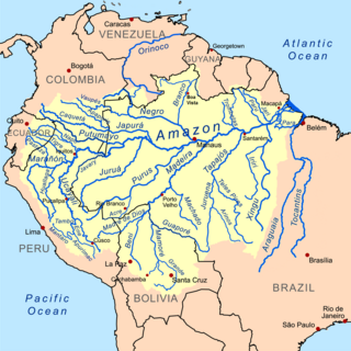
The Tigre River is a Peruvian tributary of the Marañón River west of the Nanay River. It is navigable for 125 mi (201 km) from its confluence with the Marañón. It forms from the confluence of the Ecuadorian rivers Cunambo and Pintoyacu at the Peruvian border. Like the Nanay, it flows entirely on the plains. Its mouth is 42 mi (68 km) west of the junction of the Ucayali River with the Marañón. Continuing west from the Tigre along the Marañón River we have the Parinari, Chambira, and Nucuray, all short lowland streams, resembling the Nanay in character. Tigre is Spanish for "tiger" the vernacular name in the region for the Jaguar.

Ucayali River river in Peru

The Ucayali River arises about 110 km (68 mi) north of Lake Titicaca, in the Arequipa region of Peru. The Amazon River takes its name close to Nauta city, at the confluence of the Marañón and Ucayali rivers. The Ucayali becomes a major tributary of the Amazon River. Navigation was blocked by lengthy sections of rapids. The city of Pucallpa is located on the banks of the Ucayali.

Department of Huánuco Region in 11 provinces and 76 districts, Peru

Huánuco is a department in central Peru. It is bordered by the La Libertad, San Martín, Loreto and Ucayali regions in the north, the Ucayali Region in the east, the Pasco Region in the south and the Lima and Ancash regions in the west. Its capital is the city Huánuco.

Department of San Martín Region in 10 provinces and 77 districts, Peru

San Martín is a department in northern Peru. Most of the department is located in the upper part of the Peruvian Amazon rainforest. Its capital is Moyobamba and the largest city in the department is Tarapoto.

Punchana Town in Loreto, Peru

Punchana is the capital of the Punchana District in the Maynas Province of the Loreto Region in northeastern Peru, in the Peruvian Amazon Jungle. It is a neighborhood on the outskirts of the city of Iquitos, located on the Amazon and the Nanay Rivers.

Maynas Province, Peru Province in Loreto, Peru

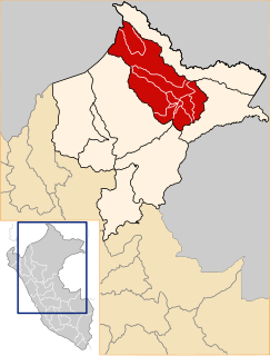
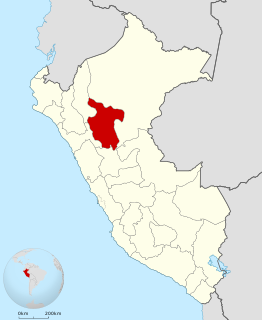
Maynas is a province in the Loreto Region in northeastern Peru. Its capital, Iquitos, is also Loreto's regional capital and the largest city in the Peruvian Amazon Rainforest.

History of the Ecuadorian–Peruvian territorial dispute

The territorial dispute between Ecuador and Peru was the source of the longest-running international armed conflict in the Western Hemisphere. This dispute was a consequence of each country's interpretation of what Real Cedulas Spain used to precisely define its colonial territories in the Americas. After independence all of Spain's colonial territories signed and agreed to proclaim their limits in the basis of the principle uti possidetis juris which accepts the Spanish colonial borders of 1810 as the borders of the new republics. Thus the borders of Gran Colombia which included Ecuador, Colombia and Venezuela would follow the borders of the Viceroyalty of New Granada, and Peru the Viceroyalty of Peru in 1810. However, Peru was not satisfied with this and tried to set the date of her Uti Possitedis to 1824- a time when Peru was officially independent with territories Peru militarily occupied since 1820. Tumbes and Jaen de Bracamoros, to which Peru had no colonial titles, were territories that declared their independence in 1820 and were militarily occupied by Peruvian patriot forces that convinced the people in these territories to join Peru. Because of this, Peru claims that part of its western territorial borders where it lacks title is derived from free determination of its people in the border areas after independence. In the eastern section known as Maynas or Mainas, which was the sparsely inhabited and entirely Amazon Basin, Peru bases its legal claims on the disputed Real Cedula of 1802. Gran Colombia which declared independence 2 years earlier in 1819 and helped to liberate Peru in the Battle of Junin and Ayacucho bases its rights on the clear and undisputed Real Cedulas of 1717, 1739 and 1740 and declares that the Real Cedula of 1802 is not political in nature, but was meant only for ecclesiastical and military jurisdiction.

Yurimaguas Town in Loreto, Peru

Yurimaguas is a port town in the Loreto Region of the northeastern Peruvian Amazon. Historically associated with Maynas, the culturally diverse town is affectionately known as the "Pearl of the Huallaga". Yurimaguas is located at the confluence of the majestic Huallaga and Paranapura Rivers in the steamy rainforests of northeastern Peru. It is the capital of both Alto Amazonas Province and Yurimaguas District, and had a population estimated at about 62,903 inhabitants (2017).

Cocama (Kokáma) is an indigenous language spoken by thousands of native people in western South America. It is spoken along the banks of the Northeastern lower Ucayali, lower Marañón, and Huallaga rivers and in neighboring areas of Brazil and an isolated area in Colombia. There are three dialects. The robust dialect is known as Cocama, Kokama, Kukama-Kukamiria, Ucayali, Xibitaoan, Huallaga, Pampadeque, and Pandequebo. By 1999, Cocamilla (Kokamíya) was moribund, being only spoken by people over 40.

Ubigeo is the coding system for geographical locations in Peru used by the National Statistics and Computing Institute to code the first-level administrative subdivision: regions, the second-level administrative subdivision: provinces and the third-level administrative subdivision: districts.

Belén District, Maynas District in Loreto, Peru

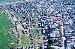
Belén District is one of thirteen districts of the Maynas Province in Peru. Belén lies at the edge of the city of Iquitos, in the floodplain of the Itaya River. It is home to some 65,000 people, most of them poor, and many of whom live in extreme poverty. The housing does not have clean water, proper sanitation, or electric power distribution.

Carlos Fitzcarrald Peruvian businessman

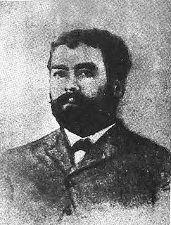
Carlos Fermín Fitzcarrald was a Peruvian rubber baron. He was born in San Luis, Ancash.

Tapiche Reserve nature reserve in Peru

The Tapiche Reserve is a private conservation property located in Tapiche District, Requena Province, Loreto Region in Peru. The 1,540 hectare reserve, accessible only by waterway, is located 340 km up river from Iquitos on the Tapiche River. The reserve comprises several types of lowland Amazonian forests, including igapo, varzea, and terra firme. The reserve represents one of the few areas in the Amazon basin where these forest types can be found in close proximity. The reserve spans both sides of the Tapiche River east of the Ucayali River; and is home to endangered species such as jaguar, bald uakari, giant armadillo, the Brazilian tapir, the Amazonian manatee, harpy eagle, cedar, mahogany and others. Inside the reserve, there are bodies of water and swamps including lakes, canals, oxbows, aguajales, and restingas. It has annual temperatures ranging from 25 °C (77 °F) to 33 °C (91 °F) and an annual rain fall of about 3 meters, permitting an immense variety of species to thrive in the area. A land survey and rapid species inventory of Tapiche Ohara’s Reserve was performed in 2011. The species inventory is reproduced below in table format. The reserve is designated by the Peruvian government as a Private Conservation Area (PCA).

2012 Loreto floods

The 2012 Loreto floods is an orange-alert weather event that affected Loreto Region, Peru that took place in the first months of 2012. February and March were the wettest months along the Peruvian Amazon. The area most affected in Loreto are villages, towns and coasts of the provincial capital, Iquitos. It is the first and strongest historical flood series in the history of Loreto, preceding the floods in 1986.

Lake Zungarococha (possibly from Quechua sunkaru a South American cat fish, qucha lake, is a lake in Peru. It lies near the Nanay River, southwest of Iquitos, in the Loreto Region, Maynas Province, San Juan Bautista District.

Tamshiyacu Tahuayo Regional Conservation Area Protected area of regional management level

Tamshiyacu Tahuayo Regional Conservation Area is a protected area located south east of Iquitos, extending over the Peruvian department of Loreto, provinces of Maynas, Ramón Castilla and Requena. It was established by the Peruvian Ministry of Environment on May 15, 2009. The reserve is managed and funded by the Regional Government of Loreto.

Itaya River river passing through the city of Iquitos and flows into the Amazon River

The Itaya River is a tributary of the Amazon River via the Nanay River in northern Peru. The Itaya flows alongside the city of Iquitos and the district of Belén.

References

  1. Dean, Bartholomew 2009 Urarina Society, Cosmology, and History in Peruvian Amazonia, Gainesville: University Press of Florida ISBN   978-0-8130-3378-5
  2. inei.gob.pe INEI, Peru, Censos Nacionales 2007