Moquegua Region

Last updated

Moquegua Region
Vallemoquegua1.jpg
Moquegua valley
Bandera Moquegua Peru.png
Flag
Escudo Moquegua Peru.png
Seal
Peru - Moquegua Department (locator map).svg
Location of the Department of Moquegua in Peru
Coordinates: 16°48′S70°48′W / 16.8°S 70.8°W / -16.8; -70.8 Coordinates: 16°48′S70°48′W / 16.8°S 70.8°W / -16.8; -70.8
Country Peru
Subdivisions3 provinces and 20 districts
Largest city Moquegua
Capital Moquegua
Government
  GovernorJaime Rodríguez Villanueva
(2015–2018)
Area
  Total15,733.97 km2 (6,074.92 sq mi)
Highest elevation
3,756 m (12,323 ft)
Lowest elevation
0 m (0 ft)
Population
(2004 estimate)
  Total163,757
  Density10/km2 (27/sq mi)
UBIGEO
18
Dialing code 053
ISO 3166 code PE-MOQ
Principal resources Copper, olives and avocado.
Poverty rate29.6%
Percentage of Peru's GDP 1.43%
Website www.regionmoquegua.gob.pe

Moquegua (Spanish pronunciation:  [moˈkeɣa] ) is a region in southern Peru that extends from the coast to the highlands. Its capital is the city of Moquegua, its beautiful historical center is grandiose monument of the creativity of its people, the highest expression of architecture is reflected in the traditional slanted roofs, whose traditional architecture form trapesoidal give a unique and singular aspect to this beautiful city. The city of Moquegua is the political, administrative, cultural, economic and commercial center of all the department of Moquegua, and is among the main Peruvian cities for its high rates of GDP and national education.

Peru republic in South America

Peru, officially the Republic of Peru, is a country in western South America. It is bordered in the north by Ecuador and Colombia, in the east by Brazil, in the southeast by Bolivia, in the south by Chile, and in the west by the Pacific Ocean. Peru is a megadiverse country with habitats ranging from the arid plains of the Pacific coastal region in the west to the peaks of the Andes mountains vertically extending from the north to the southeast of the country to the tropical Amazon Basin rainforest in the east with the Amazon river.

Moquegua City in Peru

Moquegua is a city in southern Peru, located in the Moquegua Region, of which it is the capital. It is also capital of Mariscal Nieto Province and Moquegua District. It is located 1144 kilometers south of the capital city of Lima.

Contents

Geography

The region's volcanoes and its geomorphology make its geography remarkable. It is formed by upstream portion of the Tambo River, one of the most torrential coastal rivers, which forms deep valleys that can be divided into three sectors, the first one being in the northwest, forming the Puquina-La Capilla sector. These are veritable oasis enclaved in the rocks; arid hillsides and some terraces where horticulture is possible. High quality alfalfa as well as fruits, especially grapes, are produced here, due to a good climate and a rich soil. The second sector is the valley of Omate, one of the most populated and fertile soils of the department. The Ubinas Volcano, Peru's most active volcano, is located nearby. In the hillsides, the land is fertile in contrast with the desolation and sterility of its highlands. In the southern part of the Tambo River is located the town of Carumas, which along with Puquina and Omate, are the vital centers of this geography. The Moquegua River is a short run one and is formed by its tributaries: the Torata, Huaracane and Tumilaca rivers. After passing through the regional capital, it digs deep into a canyon called the Osmare.

Volcano A rupture in the crust of a planetary-mass object that allows hot lava, volcanic ash, and gases to escape from a magma chamber below the surface

A volcano is a rupture in the crust of a planetary-mass object, such as Earth, that allows hot lava, volcanic ash, and gases to escape from a magma chamber below the surface.

Tambo River (Peru) river of Peru

The Tambo River is a Peruvian river on the eastern slopes of the Andes. The name only refers to a relatively short section; about 159 km (99 mi) long. It starts at the confluence of the Ene and Perené Rivers at the town of Puerto Prado. From here the Tambo River flows 70 km (43 mi) in an easterly direction and then turns north. When merging with the Urubamba River at the town of Atalaya, it becomes the Ucayali River.

Alfalfa species of plant, alfalfa

Alfalfa, also called lucerne and called Medicago sativa in binomial nomenclature, is a perennial flowering plant in the legume family Fabaceae. It is cultivated as an important forage crop in many countries around the world. It is used for grazing, hay, and silage, as well as a green manure and cover crop. The name alfalfa is used in North America. The name lucerne is the more commonly used name in the United Kingdom, South Africa, Australia, and New Zealand. The plant superficially resembles clover, especially while young, when trifoliate leaves comprising round leaflets predominate. Later in maturity, leaflets are elongated. It has clusters of small purple flowers followed by fruits spiralled in 2 to 3 turns containing 10–20 seeds. Alfalfa is native to warmer temperate climates. It has been cultivated as livestock fodder since at least the era of the ancient Greeks and Romans. Alfalfa sprouts are a common ingredient in dishes made in South Indian cuisine.

Boundaries

The Region of Moquegua is bordered by the Arequipa Region in the north, the Puno Region in the east, the Tacna Region in the south and the Pacific Ocean in the west.

Political division

Map of the Moquegua region showing its provinces Provinces of the Moquegua region in Peru.png
Map of the Moquegua region showing its provinces

The region is divided into 3 provinces (Spanish : provincias, singular: provincia), which are composed of 20 districts (distritos, singular: distrito). The provinces, with their capitals in parenthesis, are:

Spanish language Romance language

Spanish or Castilian is a Romance language that originated in the Castile region of Spain and today has hundreds of millions of native speakers in the Americas and Spain. It is a global language and the world's second-most spoken native language, after Mandarin Chinese.

General Sánchez Cerro Province Province in Moquegua, Peru

The General Sánchez Cerro Province is the smallest of three provinces in the Moquegua Region of Peru. The capital of the province is Omate. The province was named after the former Peruvian army officer and president Luis Miguel Sánchez Cerro.

Omate Village in Moquegua, Peru

Omate is a town in Southern Peru, capital of the province General Sánchez Cerro in the region Moquegua.

Ilo Province Province in Moquegua, Peru

The Ilo Province is one of three provinces that make up the Moquegua Region in Peru. The province is the largest mining center in all of the southern Peru area.

Demographics

Population

According to the 1993 Census, the Moquegua Region has a population of 128,747 inhabitants, 51.9% of which (66,843) are male and 48.1% (61,904) are female.

As of 2002, the Instituto Nacional de Estadística e Informática estimates the region's population to be 156,750.

Languages

According to the last census in Peru in 2007, the languages learnt first by the residents were Spanish (79.37%), Aymara (10.71%), Quechua (9.57%) and Asháninka (0.04%). Other indigenous languages were learnt first by 0.19% and foreign languages by 0.04%. [1] The Quechua variety spoken in Moquegua is Cusco–Collao Quechua. The following table shows the results concerning the language learnt first in the Moquegua Region by province: [1]

ProvinceQuechuaAymaraAsháninkaAnother native languageSpanishForeign languageDeaf or muteTotal
G. Sánchez Cerro8,90547052214,35432223,781
Ilo2,7355,1381911752,519362760,591
Mariscal Nieto3,09310,8753115455,268236569,509
Total14,73316,48355293122,14162114153,881
%9.5710.710.040.1979.370.040.07100.00

Immigration

Persons originating from other regions of the country make up 37.8% of the population and 0.2% of residents were born abroad.

The largest immigrant groups come from the Puno Region (14.7% of the total population) and the Arequipa Region (9.9%).

Age

The population is spread out with 43.3% under the age of 20, 9.9% from 20 to 24, 28.6% from 25 to 44, 13.4% from 45 to 64, and 4.8% who are 65 years of age or older.

Education

Secondary education has been attended by 33.3% of the population and 5.5% also have graduated from non-university higher education, while 4.3% have complete university studies. 37.9% only have attended primary education and 7.1% have not had any education.

The illiteracy rate in the region is 10%.

History

Inca oral tradition as documented by the Spanish chroniclers has long held that the present-day Moquegua Region was inhabited by small groups of natives known as pukinas and qullas long before the arrival of the Incas. According to chronicler Garcilaso de la Vega, it was Inca Mayta Cápac who organized the military expedition to expand the domains of the Cusco monarchs along this part of the coast. Since these were fertile lands, capable of supporting a larger population, the Inca army officers in charge decided to establish the towns of Cuchuna and Moquegua. In doing so, they were also protecting the Inca domain over the conquered lands.

Archaeological research conducted over the past several decades has shed considerable light on the ancient history of Moquegua, giving this remote section of Peru a unique place in the history of Peru. Archaeological surveys and excavations, documented in myriad professional publications, as well as books for the public available at Moquegua's Museo Contisuyo, demonstrate a sequence of occupation stretching from more than 10,000 B.C. through the present day.

There is no accurate data on the Spanish conquest or the founding of the city of Moquegua by its army. Presumably, it was founded on 25 November 1541 by Pedro Cansino and his wife, Josefa de Bilbao.

The named after him.

During the War of the Pacific, Moquegua suffered the invasion of Chilean troops. This army looted all buildings —including churches—, tortured women, and took people's jewelry.

Tourism

In the city

Plaza de Armas in the city of Moquegua, the background shows the city's cathedral. Plazamoquegua.JPG
Plaza de Armas in the city of Moquegua, the background shows the city's cathedral.

The attractions in the city of Moquegua are Main Square which features a fountain made and built in France by the Engineer Gustave Eifel, Santo Domingo Church contains the image of Santa Fortuna, a martyr, from the first centuries of Christianity who is worshipped by the faithful. The Jose Carlos Mariategui Museum is located in the main square and it presentes the life and works of who is widely considered as one of the most influential intellectuals of the 20th Century in Latin America. Contisuyo Museum is also located in the city of Moquegua. The museum exhibits a variety of archaeological remains of the Uros and Puquina cultures as well as an explanation of the time period in which different cultures settle in this region. [2]

Other attractions in the city are casa del regidor perpetuo de la ciudad and casa de Alayza, which are houses built with architecture of the eighteenth century. [3]

Outside the city

Attractions outside the city are Samegua which has the best typical food restaurants for tourists. Samegua also produces good quality avocados which are the reason why it's called the avocado territory. Another attraction located 24 km from Moquegua is Torata that is a district that offers the visitor a picturesque environment in which the visitor can admire the traditional ridged roof houses, the Torata Church, the stone windmills from the viceroyal period, and Sabaya and Camata an Inca administrative center known as the Machu Picchu of Moquegua. In addition at about 18 km northeast of Moquegua is found Mount Baul a geological formation which appear to have been cut perpendicular in the top area and it also bears a resemblance to the type of chest of trunk that was utilized all over Peru in the old days. [2]

Another attraction outside of the city is Ilo located 90 km from Moquegua. Ilo is one of the most tourist visited places in Moquegua. The main places to visit in this town are: Punta Coles, Los Olivares, and El Puerto, La Glorieta Jose Galvez, San Geronino church and beautiful beaches like Roca del Rio. [2] [4]

Also at about 140 km northwest of Moquegua is Omate, town known as Villa de Omate that produces pisco and wine. The town is also considered to be one of the most important producing centers in Peru. The attractions in Omate are The Viceroyal Church, the Quinistacas Sanctuary, the Utucam Thermal baths, and the Tambo river. Other places of interest in the Outskirts of Moquegua are Puente Bello, Putina, Ichuna and Tolapalca thermal baths. [2]

Festivities

In Moquegua there are two main Festivities that attract tourist; one of them is Santo Domingo Fortunata Festival. This festival is held on 14 October; it is an important religious festival in which the faithful from not only Moquegua but different places in Peru traveled to this town to join the Procession of the Image of the virgin and martyr St. Fortunata. Activities such as fairs, cultural and recreational events occur in this festival too.

The other main festival for the region of Moquegua is Moquegua Tourism Week. This festival starts in November and it holds competitions of typical dishes and beverages, a show with typical dances, and fairs. [2]

Gastronomy

The Region of Moquegua offers a variety of typical food to his visitors. Some of the typical dishes offered are patasca moqueguana or Caldo de Mondogo, which is a soup made with cow innards, corn, and mint and Picante de Cuy that is Guinea pig stew cooked in a peanut and hot pepper sauce. Other typical dishes are Chupe de Camarones that is a shrimp soup made with eggs, milk, and oregano. In addition, there is also the well known, Cebiche de Jurel or Mixto, Parihuela, Chupin de Pejesapo, Sudado de machas, Aguadito de Mariscos, Chicharron de Pulpo, Picante de Mariscos, and Cuy Frito.

The most typical desserts in the Moquegua region are majarblanco which is a sweetened, condensed milk cooked down and used as a spread, alfar de penco which is a soft cookie, corn cake, guargueros, and oquendos. The most traditional drinks are macerado de damasco which is a peach liqueur made with Pisco, leche de monja, a liqueur that is made with a cordial, eggs, and lemon. Other traditional drinks are Chimbango de tres higos a liqueur combined of red, black, and green figs. In addition wine, pisco, licorice, cognac, and other pisco based fruit liqueurs are traditional drinks of this region. [5]

Transportation and Tourist Information

Modes of transportation to Moquegua Region are by air or overland transport. The Moquegua Region has two airports: Hernan Turque Podesta Airport in Moquegua city and Ilo Airport located in Ilo. Overland transportation in Moquegua city is by bus, and in Ilo there is a bus station called Pampa Inalambrica. [5]

See also

Related Research Articles

Pisco, Peru Place in Ica, Peru

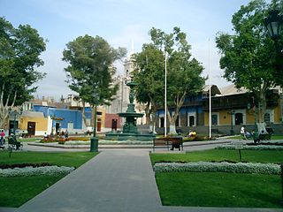
Pisco is a small city located in the Department of Ica of Peru, the capital of the Pisco Province. The city is around 9 metres above sea level. Pisco was founded in 1640, close to the indigenous emplacement of the same name. Pisco originally prospered because of its nearby vineyards and became noted for its grape brandy or pisco which was exported from its port. Pisco has an estimated population of 104,656.

Department of Junín Region in 9 provinces and 123 districts, Peru

Junín is a region in the central highlands and westernmost Peruvian Amazon. Its capital is Huancayo.

Mollendo Town in Arequipa Region, Peru

Mollendo is a town bordering the Pacific Ocean in southern Peru. It is located in the Arequipa Region and is the capital of both the Islay Province and the Mollendo District. Mollendo was the main port in the Peruvian southern coast until Matarani was developed about 50 years ago; the port of Mollendo only serves fishermen for the local economy currently and all the commercial shipping is done through Matarani 12 kilometers north; the old port is in ruins. From about 1830 to 1880 it was important in the Guano trade.

Qullasuyu

Qullasuyu was the southeastern provincial region of the Inca Empire. Qullasuyu is the region of the Qulla and related specifically to the native Qulla Quechuas who primarily resided in areas such as Cochabamba and Potosí. Most Aymara territories which are now largely incorporated into the modern South American states of northern Chile, Argentina, Peru and Bolivia were annexed during the reign of Sapa Inca Huayna Cápac in the sixteenth century.

Lunahuaná Town in Lima, Peru

Lunahuaná is a small town in the Cañete Province in Peru. The town lies about 187 km south of Lima in the Lunahuaná valley at the bank of Cañete River. Due to the unique landscape, Lunahuaná is a very popular destination for both Peruvians and foreign tourists. According to the 2017 census, there were 4,393 inhabitants.

Ilo, Peru City in Moquegua, Peru

Ilo is a port city in southern Peru, with 66,118 inhabitants. It is the second largest city in the Moquegua Region and capital of the Ilo Province.

Puquina language language

Puquina is an extinct language once spoken by a native ethnic group in the region surrounding Lake Titicaca and in the north of Chile. It is often associated with the culture that built Tiwanaku.

Mariscal Luzuriaga Province Province in Ancash, Peru

The Mariscal Luzuriaga Province is one of 20 provinces of the Ancash Region in Peru. It was created by law 12541 on January 12, 1956 and named after the Peruvian marshal and Argentine general Toribio de Luzuriaga

Mariscal Nieto Province Province in Moquegua, Peru

The Mariscal Nieto Province is the largest of three provinces that make up the Moquegua Region of Peru. The capital of the province is the city of Moquegua.

Pomabamba Province Province in Ancash, Peru

The Pomabamba Province is one of twenty provinces of the Ancash Region in Peru. It was formerly called Pumapampa and today it is also known as "The City of Cedars". It is located at the left bank of the Pomabamba river, at 3,063 meters (10,049 ft) above sea level. It was created by law on February 21, 1861.

Osmore River river in Peru

Osmore River system flows northeast to southwest in the Moquegua Region of southern coastal Peru. The river has its origin in the snow peaks of the Chuqi Ananta and Arundane mountains, at an elevation of 5,100 metres (16,700 ft). It changes names as it descends from the Andes: From its origin it is called the Moquegua, then Osmore in the middle valley as Rio Coscori and Rio Tumilaca including where the river disappears into subterranean channels, and further down in the lower reaches as Rio Ilo.

Peruvian Pisco grape brandy produced in Peru

In Peru and other countries, pisco is a "designation of origin" that is reserved for the alcoholic beverage belonging to a variety of grape aguardiente produced in Peru since the late 16th century. It is the typical destillate of this country, elaborated from fermented wine of certain grapes, whose value has crossed its borders, as evidenced by the records of shipments made through the port of Pisco to Europe and other parts of the Americas since the 17th century, places such as England, Spain, Portugal, Guatemala, Panama and United States, from the mid-19th century.

Inka Tampu or Inkatampu is an archaeological site in Peru. It is located in the Cusco Region, La Convención Province, Vilcabamba District. The archaeological group is situated on top of a mountain named Inka Tampu (Inka Tambo).

Chuquiananta mountain in Peru

Chuquiananta is a mountain in the Andes of southern Peru, about 5,300 metres (17,388 ft) high. It is situated in the Moquegua Region, Mariscal Nieto Province, Torata District, and in the Tacna Region, Candarave Province, Camilaca District. Chuquiananta lies south-west of Tutupaca volcano, south-east of Pomani.

Apacheta Limani mountain in Peru

Apacheta Limani is a mountain in the Andes of southern Peru, about 5,300 metres (17,388 ft) high. It is located in the Moquegua Region, Mariscal Nieto Province, Torata District, and in the Tacna Region, Candarave Province, Camilaca District. Apacheta Limani is situated south of the mountain Limani, northwest of the Tutupaca volcano, Chuquiananta and Huañuma, and northeast of Pomani. The Asana River originates near Apacheta Limani. It flows to the southwest.

Surehuayco mountain in Peru

Surehuayco and from Quechua Suri Wayq'u) is a mountain in the Andes of southern Peru, about 4,800 metres (15,748 ft) high. It is situated in the Moquegua Region, Mariscal Nieto Province, Torata District. It lies southwest of the mountain Iruma and east of Achucallani. Surehuayco is also the name of an intermittent stream north of the mountain.

Cerro Baúl mountain in Peru

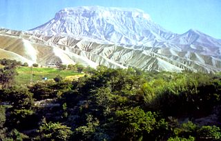
Cerro Baúl is an ancient political outpost and ceremonial center settlement in Peru established by the pre-Incan empire called the Wari. It was evacuated after a siege by the Inca Empire in about 1475. Cerro Baúl is a terraced mountain, 2000 feet above its surroundings, with a settlement on the cliff tops themselves and in the immediate surroundings. Among other finds are the remnants of a brewery and large buildings that may have been used for ceremonial feasting. There is evidence of damage that has been interpreted as a careful and deliberate destruction, by the city's own people, of several buildings prior to the mesa's being vacated.

References

  1. 1 2 inei.gob.pe Archived 27 January 2013 at the Wayback Machine INEI, Peru, Censos Nacionales 2007
  2. 1 2 3 4 5 "Tourist Information Moquegua" (PDF). Retrieved 5 October 2010.
  3. "Peruvian Cities" . Retrieved 16 October 2010.
  4. "La glorieta Jose Galvez" . Retrieved 18 October 2010.
  5. 1 2 "Useful Information of Moquegua" . Retrieved 5 October 2010.