Sayacmarca

Last updated
Sayacmarca
Sayacmarka.jpg
Partial view of Sayacmarca.
Peru physical map.svg
Archaeological site icon (red).svg
Shown within Peru
LocationFlag of Peru.svg  Peru
Cusco Region
TypeSettlement
History
Cultures Inca

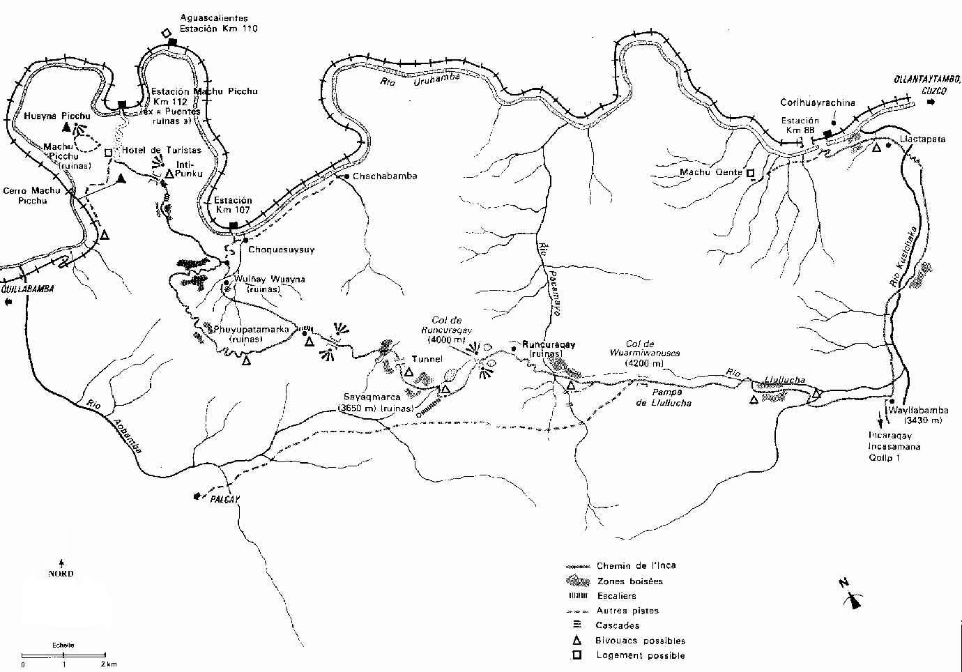
Sayacmarca [1] [2] [3] is an archaeological site in Peru located in the Cusco Region, Urubamba Province, Machupicchu District. It is situated southwest of the archaeological site Runkuraqay and the Runkuraqay pass and southeast of the sites Phuyupatamarka and Qunchamarka. [4] [5]

Hiram Bingham III visited the site in April 1915, referring to it as Cedrobamba, or cedar plain. [6]

See also

Related Research Articles

Machu Picchu 16th-century Inca citadel in the Peruvian Andes and UNESCO World Heritage Site

Machu Picchu is a 15th-century Inca citadel, located in the Eastern Cordillera of southern Peru, on a 2,430-metre (7,970 ft) mountain ridge. It is located in the Machupicchu District within Urubamba Province above the Sacred Valley, which is 80 kilometres (50 mi) northwest of Cuzco. The Urubamba River flows past it, cutting through the Cordillera and creating a canyon with a tropical mountain climate.

Hiram Bingham III American academic, explorer, treasure hunter and politician

Hiram Bingham III was an American academic, explorer and politician. He made public the existence of the Inca citadel of Machu Picchu in 1911 with the guidance of local indigenous farmers. Later, Bingham served as Governor of Connecticut for a single day, and then as a member of the United States Senate.

Vilcabamba, Peru the capital of the Neo-Inca State

Vilcabamba, Willkapampa is often called the Lost City of the Incas. Vilcabamba means "sacred plain" in Quechua. The modern name for the Inca ruins of Vilcabamba is Espiritu Pampa. Vilcabamba is located in Echarate District of La Convención Province in the Cuzco Region of Peru.

Ollantaytambo Town in Cusco, Peru

Ollantaytambo is a town and an Inca archaeological site in southern Peru some 72 km (45 mi) by road northwest of the city of Cusco. It is located at an altitude of 2,792 m (9,160 ft) above sea level in the district of Ollantaytambo, province of Urubamba, Cusco region. During the Inca Empire, Ollantaytambo was the royal estate of Emperor Pachacuti, who conquered the region, and built the town and a ceremonial center. At the time of the Spanish conquest of Peru, it served as a stronghold for Manco Inca Yupanqui, leader of the Inca resistance. Nowadays, located in what is called the Sacred Valley of the Incas, it is an important tourist attraction on account of its Inca ruins and its location en route to one of the most common starting points for the four-day, three-night hike known as the Inca Trail.

Llaqtapata

Llaqtapata (Quechua) llaqta place, pata elevated place / above, at the top / edge, bank, shore, pronounced 'yakta-pahta', hispanicized Llactapata) is an archaeological site about 5 km (3.1 mi) west of Machu Picchu. The complex is located in the Cusco Region, La Convención Province, Santa Teresa District, high on a ridge between the Ahobamba and Santa Teresa drainages.

Coricancha sun temple

Coricancha, Koricancha, Qoricancha or Qorikancha was the most important temple in the Inca Empire. It is located in Cusco, Peru, which was the capital of the empire.

Urubamba Province Province in Cusco, Peru

Urubamba Province is one of thirteen provinces in the Cusco Region in the southern highlands of Peru.

Yucay Village in Cusco, Peru

Yucay is a town in southern Peru. It is the capital of the Yucay District, which is near the center of Urubamba Province. Urubamba Province is in the Cusco Region of southern Peru.

Inca Trail to Machu Picchu Ancient trail in Peru

The Inca Trail to Machu Picchu is a hiking trail in Peru that terminates at Machu Picchu. It consists of three overlapping trails: Mollepata, Classic, and One Day. Mollepata is the longest of the three routes with the highest mountain pass and intersects with the Classic route before crossing Warmiwañusqa. Located in the Andes mountain range, the trail passes through several types of Andean environments including cloud forest and alpine tundra. Settlements, tunnels, and many Incan ruins are located along the trail before ending the terminus at the Sun Gate on Machu Picchu mountain. The two longer routes require an ascent to beyond 4,200 metres (13,800 ft) above sea level, which can result in altitude sickness.

Cusichaca River

Cusichaca River, is a river in Peru located in the Cusco Region, Urubamba Province, on the border of the districts Machupicchu and Ollantaytambo. Its waters flow to the Vilcanota River.

Patallacta mountain

Patallacta, Llactapata or Q'ente Marka is an archaeological site in Peru located in the Cusco Region, Urubamba Province, Machupicchu District. It is situated southeast of the site Machu Picchu, at the confluence of the rivers Cusichaca and Vilcanota on a mountain named Patallacta.

Warmi Wañusqa

Warmi Wañusqa is a mountain pass in the Cusco Region in Peru. It is located in the Urubamba Province, Machupicchu District. Warmi Wañusqa lies on the Inca Trail to Machu Pikchu, southwest of the archaeological site of Patallaqta. It is situated at a height of 4,200 metres (13,780 ft).

Ñusta Hispana

Ñusta HispanaÑusta Ispanan, previously known as Chuquipalta is an archaeological site in Peru. It is located at Vilcabamba, La Convención Province, Cusco Region.

Runkuraqay mountain in Peru

Runkuraqay or Runku Raqay is an archaeological site on a mountain of the same name in Peru located in the Cusco Region, Urubamba Province, Machupicchu District. It is situated southeast of the archaeological site Machu Picchu and south of the Vilcanota river. The ruins lie on the southern slope of the mountain Runkuraqay near the Runkuraqay pass, northeast of the archaeological site Sayacmarca and southeast of the site Qunchamarka.

Huillca Raccay

Huillca Raccay or Huillca Racay is an archaeological site in Peru located in the Cusco Region, Urubamba Province, Ollantaytambo District. It is situated southeast of the archaeological site Patallacta above the right bank of the little river Pampa Qhawa, an affluent of the Vilcanota River, near the village Chamana.

Qunchamarka

Qunchamarka is an archaeological site in Peru located in the Cusco Region, Urubamba Province, Machupicchu District, southwest of the mountain Runkuraqay. It lies between the archaeological sites Sayaqmarka and Phuyupatamarka on the Inca Trail to Machu Picchu.

Machu Colca

Machu Colca, Machuqolqa or Machu Qollqa is an archaeological site in Peru. It lies in the Cusco Region, Urubamba Province, Huayllabamba District, a few minutes outside of Chinchero. Machu Colca is situated at about 3,850 metres (12,631 ft) of elevation, above the left bank of the Urubamba River, near the village of Raqch'i (Raqchi).

Wilca

Wilca is an archaeological site in Peru. It is situated in the Amazonas Region, Utcubamba Province, in the east of the Cajaruro District, near the border with the Bongara Province.

Quriwayrachina or Quri Wayrachina is an archaeological site with agricultural terraces in Peru. It is situated in the Cusco Region, Anta Province. The terraces lie about 4 kilometres (2.5 mi) north of the terraces of Zurite.

Jatunjasa (Cusco) mountain in Peru

Jatunjasa, also known as Incachiriasca, is a 5,338-metre-high (17,513 ft) mountain in the Vilcabamba mountain range in the Andes of Peru. It is located in the Cusco Region, Anta Province, Limatambo District, and in the Urubamba Province, Ollantaytambo District. Jatunjasa lies south of Salcantay.

References

  1. Nair, Stella (2015). At Home with the Sapa Inca: Architecture, Space, and Legacy at Chinchero. University of Texas Press. p. 207. ISBN   9781477302507.
  2. Bradt, Hilary; Jarvis, Kathy (2014). Trekking in Peru: 50 Best Walks and Hikes. Bradt Travel Guides. pp. 290, 296. ISBN   9781841624921.
  3. Kaufmann, H. W.; Kaufmann, J. E. (2012). Fortifications of the Incas: 1200–1531. Bloomsbury Publishing. p. 37. ISBN   9781849080460.
  4. nroirand.free.fr Sketch map of the Inca trail
  5. escale.minedu.gob.pe - UGEL map of the Urubamba Province (Cusco Region)
  6. Bingham, Hiram (1952). Lost City of the Incas . Weidenfeld & Nicolson. pp.  22, 253-254. ISBN   9781842125854.
Location of Sayacmarca as shown on a sign near Willkaraqay Wayllabamba Puesto de Vigilancia sign.jpg
Location of Sayacmarca as shown on a sign near Willkaraqay

Coordinates: 13°13′41.4″S72°31′00.9″W / 13.228167°S 72.516917°W / -13.228167; -72.516917