Ancash is a region of northern Peru. It is bordered by La Libertad Region on the north, Huánuco and Pasco regions on the east, the Lima Region on the south, and the Pacific Ocean on the west. Its capital is the city of Huaraz, and its largest city and port is Chimbote. The name of the region originates from the Quechua word anqash, from anqas (blue) or from anka (eagle).

Huánuco is a department in central Peru. It is bordered by the La Libertad, San Martín, Loreto and Ucayali regions in the north, the Ucayali Region in the east, the Pasco Region in the south and the Lima and Ancash regions in the west. Its capital is the city Huánuco.

Lake Conococha is a South American lake located in the Andes mountains of northwestern Peru. It is located in the region of Ancash near the junction of the roads going from Callejón de Huaylas to Chiquián.
The Yungay Province is one of twenty provinces of the Ancash Region in Peru.
The Sihuas Province is one of twenty provinces of the Ancash Region in Peru.This province was created by Law nº 13485, dated at January 9 of 1961, when was president of Perou: Manuel Prado. It is bordered by provinces of Huaylas and Corongo on the west, Pallasca Province on the north, La Libertad Region on the east, and Pomabamba Province on the south.

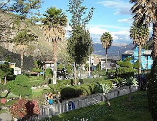
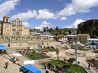
The Pomabamba Province is one of twenty provinces of the Ancash Region in Peru. It was formerly called Pumapampa and today it is also known as "The City of Cedars". It is located at the left bank of the Pomabamba river, at 3,063 meters (10,049 ft) above sea level. It was created by law on February 21, 1861.

The Pamparomas District is one of 10 districts of the Huaylas Province in the Ancash Region of Peru. The capital of the district is the village of Pamparomas. The district was founded on January 2, 1857.

Yuracmarca or Yuraq Marka is one of 10 districts of the Huaylas Province in the Ancash Region of Peru. The capital of the district is the village of Yuracmarca.

The Dos de Mayo Province is one of eleven provinces of the Huánuco Region in Peru. The capital of this province is the city of La Unión.
Haquira District is one of the six districts of the Cotabambas Province in Peru.
Caraybamba District is one of the seventeen districts of the Aymaraes Province in Peru.
Colquemarca is one of eight districts of the Chumbivilcas Province in Peru.
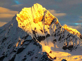
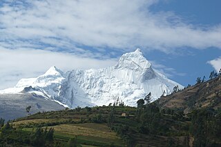
Chopicalqui or Chopicallqui is a mountain in the Cordillera Blanca area in the Andes of Peru. With a summit elevation of 6,354 metres (20,846 ft) above sea level it is one of the highest peaks of the Cordillera Blanca. It lies in Yungay Province, Ancash, between the mountains Huascarán and Contrahierbas.

Huamanmarca is an archaeological site in the region of Cusco, Peru. It is located in Huayopata District, La Convención Province, on the right bank of the Luq'umayu.

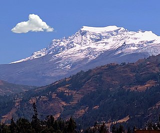
Contrahierbas, also called Yanarraju or Ruricocha, is a mountain in the Cordillera Blanca in the Andes of Peru, about 5,954 metres (19,534 ft) high. It is situated in the Ancash Region in the provinces Asunción, Carhuaz and Yungay. Contrahierbas is located inside Huascarán National Park, northeast of Hualcán.
Willkawayin is an archaeological site in Peru. It is located in the Ancash Region, Huaraz Province, Independencia District, in the village of Paria. It is situated at a height of about 3,400 m (11,200 ft).
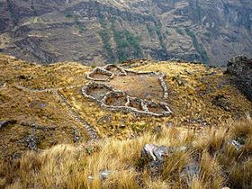
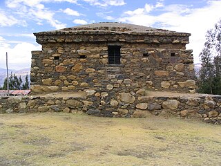
Markahirka or Marka Hirka is an archaeological site with cave paintings and stone tombs (chullpa) on a mountain of the same name in Peru. It is located in the Ancash Region, Huari Province, in the districts of Cajay and Masin. It is situated at a height of 3,580 metres (11,745 ft). Markahirka is also a good viewpoint with views into the Puchka valley (Puchca) and to the towns of Huari (Wari) and Huachis (Wachis).
Yanaque - Quilcamarca is an archaeological site in Peru. It is situated in the Ancash Region, Ocros Province, Acas District, at a height of about 3,820 metres (12,533 ft).
Waqlamarka is an archaeological site with walls and round burial towers (chullpa) in Peru. It is situated in the Junín Region, Jauja Province, Parco District.

Ancasmarca, also known as Pitusiray or Sallcasa, is a 5,198-metre-high (17,054 ft) mountain in the Urubamba mountain range in the Andes of Peru. It is located in the Cusco Region, Calca Province, Calca District, north of the Vilcanota River. Ancasmarca is situated northeast of Huamanchoque, southeast of Canchacanchajasa, south of Sahuasiray, and southwest of Ccerayoc and Condorhuachana.