
Peru is a country on the central western coast of South America facing the Pacific Ocean. It lies wholly in the Southern Hemisphere, its northernmost extreme reaching to 1.8 minutes of latitude or about 3.3 kilometres (2.1 mi) south of the equator. Peru shares land borders with Ecuador, Colombia, Brazil, Bolivia, and Chile, with its longest land border shared with Brazil.

Machu Picchu is a 15th-century Inca citadel located in the Eastern Cordillera of southern Peru on a 2,430-meter (7,970 ft) mountain ridge. It is located in the Machupicchu District within Urubamba Province above the Sacred Valley, which is 80 kilometers (50 mi) northwest of Cuzco. The Urubamba River flows past it, cutting through the Cordillera and creating a canyon with a tropical mountain climate.
Pachacamac is an archaeological site 40 kilometres (25 mi) southeast of Lima, Peru in the Valley of the Lurín River. The site was first settled around A.D. 200 and was named after the "Earth Maker" creator god Pacha Kamaq. The site flourished for about 1,300 years until the Spanish invaded. Pachacamac covers about 600 hectares of land.
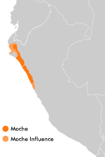
The Moche civilization flourished in northern Peru with its capital near present-day Moche, Trujillo, Peru from about 100 to 700 AD during the Regional Development Epoch. While this issue is the subject of some debate, many scholars contend that the Moche were not politically organized as a monolithic empire or state. Rather, they were likely a group of autonomous polities that shared a common culture, as seen in the rich iconography and monumental architecture that survives today.

Chiclayo is the principal city of the Lambayeque region in northern Peru. It is located 13 kilometers inland from the Pacific coast and 770 kilometers from the nation's capital, Lima.

La Libertad is a region in northwestern Peru. Formerly it was known as the Department of La Libertad. It is bordered by the Lambayeque, Cajamarca and Amazonas regions on the north, the San Martín Region on the east, the Ancash and Huánuco regions on the south and the Pacific Ocean on the west. Its capital is Trujillo, which is the nation's third biggest city. The region's main port is Salaverry, one of Peru's largest ports. The name of the region is Spanish for "freedom" or "liberty"; it was named in honor of the Intendencia of Trujillo's proclaiming independence from Spain in 1820 and fighting for that. It is the ninth smallest department in Peru, but it is also its second most populous department after Piura and its second most densely populated department after Lambayeque.

Lambayeque is a department and region in northwestern Peru known for its rich Moche and Chimú historical past. The region's name originates from the ancient pre-Inca civilization of the Lambayeque. It is the second-smallest department in Peru after Tumbes, but it is also its most densely populated department and its eighth most populous department.
Tumbes is a coastal department and region in northwestern Peru bordering Ecuador. Due to the region's location near the Equator it has a warm climate, with beaches that are considered among the finest in Peru. Despite its small area, the region contains a wide variety of ecosystems. It is the smallest department in Peru and its third least populous department after Moquegua and Madre de Dios, but it is also its third most densely populated department, after La Libertad and Lambayeque.

Chimor was the political grouping of the Chimú culture. The culture arose about 900 AD, succeeding the Moche culture, and was later conquered by the Inca emperor Topa Inca Yupanqui around 1470, fifty years before the arrival of the Spanish in the region. Chimor was the largest kingdom in the Late Intermediate Period, encompassing 1,000 kilometres of coastline.

Lambayeque is a city on the coast of northern Peru and capital of the homonymous district and province in the department of Lambayeque. It is located 4.7 km from the city of Chiclayo and 13 km from the Pacific Ocean. It is an important cultural and educational center of the department as it houses some of the most important museums in the country, such as the Royal Tombs Museum and the Brüning Museum. It was founded in 1553 under the name of San Pedro de Lambayeque by order of the Viceroy Conde de Nieva.

The Colca Canyon is a canyon of the Colca River in southern Peru, located about 160 kilometres (99 mi) northwest of Arequipa. With a depth of about 1000 - 2000 m, it is one of the deepest canyons in the world. Its length is about 70 kilometres (43 mi). The Colca Valley is a colorful Andean valley with pre-Inca rooted inhabitants, and towns founded in Spanish colonial times, still inhabited by people of the Collagua and the Cabana cultures. The local people maintain their ancestral traditions and continue to cultivate the pre-Inca stepped terraces, called andenes.
The Sican culture is the name that archaeologist Izumi Shimada gave to the culture that inhabited what is now the north coast of Peru between about 750 and 1375. According to Shimada, Sican means "temple of the Moon". The Sican culture is also referred to as Lambayeque culture, after the name of the region in Peru. It succeeded the Moche culture. There is still controversy among archeologists and anthropologists over whether the two are separate cultures. The Sican culture is divided into three major periods based on cultural changes as evidenced in archeological artifacts.

Located in the Chicama Valley, the El Brujo Archaeological Complex, just north of Trujillo, La Libertad Province, Peru, is an ancient archaeological site that was occupied from preceramic times. Considering the broad cultural sequencing, the Chicama Valley can be considered as an archaeological microcosm. The research benefits from the favourable environmental and topological conditions for material conservation.

Tumi, is a generic term encompassing the many kinds of sharp tools utilized in pre- and post-colonial eras of the Central Andes region, Tumis were employed for a diverse set of purposes such as kitchen knives, agricultural tools, warrior or hunting secondary weapons, sacrificial knives, barber implements, pendants, or medical tools. In addition, the tumi form, in metal, was used as a type of coin. Pre-columbian Tumis were usually made of metal or stone.

Illimo District is one of twelve districts of the province Lambayeque in Peru.

Bosque de Pómac Historic Sanctuary is a protected area in Peru located in the region of Lambayeque. This area preserves part of the Tumbes-Piura dry forests and several pyramids built by Pre-Columbian cultures.

The Andean civilizations were complex societies of many cultures and peoples mainly developed in the river valleys of the coastal deserts of Peru. They stretched from the Andes of southern Colombia southward down the Andes to Chile and northwest Argentina. Archaeologists believe that Andean civilizations first developed on the narrow coastal plain of the Pacific Ocean. The Caral or Norte Chico civilization of Peru is the oldest known civilization in the Americas, dating back to 3200 BCE.
The Chotuna Chornancap Archaeological Complex is an archaeological site in San Jose district, Lambayeque Region, 12 kilometres (7.5 mi) north-west of Chiclayo, Peru of a set of truncated pyramids and compounds, highlighting two pyramids: Chotuna and Chornancap, the first of them believed to be related to the legend of Naylamp. Chotuna was a ceremonial center of the Sican culture, one of the cultures of Pre-Columbian Peru, which developed between the years 700 to 1300 AD. Later the Chimu and then the Inca occupation followed. In 2011 the tomb of the so-called priestess of Chornancap was discovered.

The Aymara kingdoms, Aymara lordships or lake kingdoms were a group of native polities that flourished towards the Late Intermediate Period, after the fall of the Tiwanaku Empire, whose societies were geographically located in the Qullaw. They were developed between 1150 and 1477, before the kingdoms disappeared due to the military conquest of the Inca Empire. But the current Aymara population is estimated at two million located in the countries of Bolivia, Peru, Chile and Argentina. They used the Aymara and Puquina languages.

Huayuri, also called the Lost City of Huayuri, is a large pre-Columbian archaeological site which flourished from 1150 to 1450 CE in the Late Intermediate Period of Peru. Huayuri is located in the Peruvian coastal desert in Ica Region. Its prominence was probably dependent upon an climatic phase in which the area received greater precipitation than at earlier and later periods. The site may have been abandoned in the 16th century because of water shortages, conflict with the expanding Inca empire, or epidemics of European diseases. The town of stone houses was located in a ravine between two mountain ridges, a location possibly dictated by a need for defense. Archaeological evidence indicates Huayari relied upon rainfall harvesting for its drinking water and some of the irrigated agriculture the town needed for the subsistence of the inhabitants.


