
Cusco or Cuzco is a city in southeastern Peru near the Sacred Valley of the Andes mountain range and the Huatanay river. It is the capital of the Department of Cusco and of the Cusco Province. The city is the seventh most populous in Peru; in 2017, it had a population of 428,450. Its elevation is around 3,400 m (11,200 ft).

Machu Picchu is a 15th-century Inca citadel located in the Eastern Cordillera of southern Peru on a 2,430-meter (7,970 ft) mountain ridge. Often referred to as the "Lost City of the Incas", it is the most familiar icon of the Inca Empire. It is located in the Machupicchu District within Urubamba Province above the Sacred Valley, which is 80 kilometers (50 mi) northwest of Cusco. The Urubamba River flows past it, cutting through the Cordillera and creating a canyon with a tropical mountain climate. In reference to the site's name, for most English or Spanish speakers, the first 'c' in Picchu is silent. In English, the name is pronounced MAH-choo PEE-choo or MATCH-oo PEAK-choo, in Spanish as or, and in Quechua as.
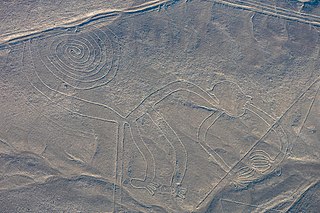
The Nazca lines are a group of geoglyphs made in the soil of the Nazca Desert in southern Peru. They were created between 500 BC and 500 AD by people making depressions or shallow incisions in the desert floor, removing pebbles and leaving different-colored dirt exposed. There are two major phases of the Nazca lines, Paracas phase, from 400 to 200 BC, and Nazca phase, from 200 BC to 500 AD. In the years leading up to 2020, between 80 and 100 new figures had been found with the use of drones, and archaeologists believe that there are more to be found.

Jujuy is a province of Argentina, located in the extreme northwest of the country, at the borders with Chile and Bolivia. The only neighboring Argentine province is Salta to the east and south.

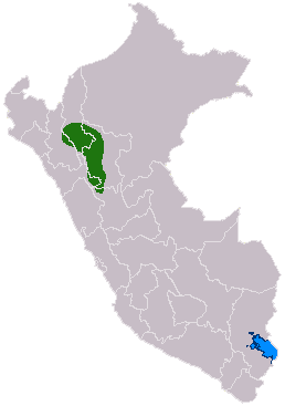
Amazonas is a department and region in northern Peru bordered by Ecuador on the north and west, Cajamarca on the west, La Libertad on the south, and Loreto and San Martín on the east. Its capital is the city of Chachapoyas.

The province of L'Aquila is the largest, most mountainous and least densely populated province of the Abruzzo region of Italy. It comprises about half the landmass of Abruzzo and occupies the western part of the region. It has borders with the provinces of Teramo to the north, Pescara and Chieti to the east, Isernia to the south and Frosinone, Rome and Rieti to the west. Its capital is the city of L'Aquila.
The Chachapoyas, also called the "Warriors of the Clouds", was a culture of the Andes living in the cloud forests of the southern part of the Department of Amazonas of present-day Peru. The Inca Empire conquered their civilization shortly before the Spanish conquest in the 16th century. At the time of the arrival of the conquistadors, the Chachapoyas were one of the many nations ruled by the Incas, although their incorporation had been difficult due to their constant resistance to Inca troops.

Chachapoyas is a city in northern Peru at an elevation of 2,335 meters (7,661 ft). The city has a population of 32,026 people (2017). Situated in the mountains far from the Peruvian coast, Chachapoyas remains fairly isolated from other regions of Peru. It is served by buses to Chiclayo and Cajamarca, and flights to domestic locations from Chachapoyas Airport.
Paititi is a legendary Inca lost city or utopian rich land. It allegedly lies east of the Andes, hidden somewhere within the remote rainforests of southeast Peru, northern Bolivia or northwest Brazil. The Paititi legend in Peru revolves around the story of the culture-hero Inkarri, who, after he had founded Q'ero and Cusco, retreated toward the jungles of Pantiacolla to live out the rest of his days in his refuge city of Paititi. Other versions of the legend see Paititi as an Inca refuge in the border area between Bolivia and Brazil.
Gran Saposoa is the name given to a series of ruins in the Andean cloud forests of the Amazonas region of Peru by American explorer Gene Savoy. Savoy hypothesized that this site is the Pre-Columbian city of Cajamarquilla, built by the Chachapoyas culture, but Chachapoyas archaeologists observed that "Cajamarquilla" is clearly identifiable in historical documents as the renamed modern highland town of Bolívar, Peru. Savoy claims that the ruins, consisting of hundreds of round stone structures, cover approximately 120 square miles, and consist of 23,950 structures. However, Gran Saposoa is not a single site, but rather a cluster of separate archaeological sites already located and published by avocational archaeologists Keith Muscutt, 2 and anthropologist Dr. Inge Schjellerup 3 in the mid 1990s. After Savoy announced his 1999 "discovery," and the sizes and populations claimed for Gran Saposoa were exposed as grossly exaggerated by professional archaeologists specializing in Chachapoyas archaeology 4. Archaeologists observed that ruins like Gran Saposoa, and Gran Vilaya "discovered" ten years prior, were long-known to Peruvian area residents and not genuine "discoveries."

Kuélap or Cuélap is a walled settlement located in the mountains near the towns of María and Tingo, in the southern part of the region of Amazonas, Peru. It was built by the Chachapoyas culture in the 6th century AD on a ridge overlooking the Utcubamba Valley.
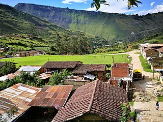
Leimebamba is a district of the province of Chachapoyas, located in the northern Peruvian department of Amazonas, in the valley of the Utcubamba River, about 60 kilometers south of Chachapoyas.
The present-day Department of Amazonas in Peru, occupying part of the western Amazon basin, carries evidence of human cultures predating the Inca Empire. The presence of the Chachapoya culture and the Wari culture in architectural excavations allow for evidence of multiple civilized presences previous to the conquest of the area by the Incan Empire.

Choquequirao is an Incan site in southern Peru, similar in structure and architecture to Machu Picchu. The ruins are buildings and terraces at levels above and below Sunch'u Pata, the truncated hill top. The hilltop was anciently leveled and ringed with stones to create a 30 by 50 m platform.

Huamachuco is a town in northern Peru and capital of the province Sánchez Carrión in La Libertad Region. The city is the seat of the Territorial Prelature of Huamachuco. Lake Sausacocha lies to the northeast.

Inti Punku or Intipunku is an archaeological site in the Cusco Region of Peru that was once a fortress of the sacred city, Machu Picchu. It is now also the name of the final section of the Incan Trail between the Sun Gate complex and the city of Machu Picchu. It was believed that the steps were a control gate for those who enter and exited the Sanctuary.

The Inca Trail to Machu Picchu is a hiking trail in Peru that terminates at Machu Picchu. It consists of three overlapping trails: Mollepata, Classic, and One Day. Mollepata is the longest of the three routes with the highest mountain pass and intersects with the Classic route before crossing Warmiwañusqa. Located in the Andes mountain range, the trail passes through several types of Andean environments including cloud forest and alpine tundra. Settlements, tunnels, and many Incan ruins are located along the trail before ending the terminus at the Sun Gate on Machu Picchu mountain. The two longer routes require an ascent to beyond 4,200 metres (13,800 ft) above sea level, which can result in altitude sickness.

Puka Pukara is a site of military ruins in Peru situated in the Cusco Region, Cusco Province, Cusco District, near Cusco. This fort is made of large walls, terraces, and staircases and was part of defense of Cusco in particular and the Inca Empire in general.

The Andean civilizations were South American complex societies of many indigenous people. They stretched down the spine of the Andes for 4,000 km (2,500 mi) from southern Colombia, to Ecuador and Peru, including the deserts of coastal Peru, to north Chile and northwest Argentina. Archaeologists believe that Andean civilizations first developed on the narrow coastal plain of the Pacific Ocean. The Caral or Norte Chico civilization of coastal Peru is the oldest known civilization in the Americas, dating back to 3500 BCE. Andean civilization is one of the six "pristine" civilizations of the world, created independently and without influence by other civilizations.

Marcahuamachuco is an archeological site of Pre-Incan ruins in the La Libertad Region of Peru. Although less well-known than other sites, it is considered significant and has been referred to by archaeologists as "Machu Picchu of the North" and "The Jewel of La Libertad."
