Huayllabamba District, Urubamba

Last updated
Huayllabamba
Wayllapampa
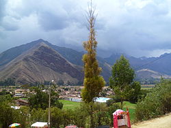
Huayllabamba.JPG
Huayllabamba
Country Flag of Peru.svg  Peru
Region Cusco
Province Urubamba
FoundedJanuary 2, 1857
Capital Huayllabamba
Government
   Mayor Segundo Fortunato Lopez Quispe
Area
  Total102.47 km2 (39.56 sq mi)
Elevation
2,866 m (9,403 ft)
Population
  Total5,185
  Density51/km2 (130/sq mi)
Time zone UTC-5 (PET)
UBIGEO 081303

Huayllabamba District is one of seven districts of the province Urubamba in Peru. The town of Huayllabamba is the capital of the district. [1]

See also

Related Research Articles

<span class="mw-page-title-main">Sihuas Province</span> Province in Ancash, Peru

The Sihuas Province is one of twenty provinces of the Ancash Region in Peru.This province was created by Law nº 13485, dated at January 9 of 1961, when was president of Perou: Manuel Prado. It is bordered by provinces of Huaylas and Corongo on the west, Pallasca Province on the north, La Libertad Region on the east, and Pomabamba Province on the south.

<span class="mw-page-title-main">Urubamba Province</span> Province in Cusco, Peru

Urubamba Province is one of thirteen provinces in the Cusco Region in the southern highlands of Peru.

<span class="mw-page-title-main">Abancay District</span> District in Apurímac, Peru

Abancay District is one of the nine districts of the Abancay Province in Peru.

San Pedro de Cachora District is one of the nine districts of the province Abancay in Peru.

Juan Espinoza Medrano District is one of the seven districts of the province Antabamba in Peru.

Anta District is one of nine districts of the Anta Province in Peru.

<span class="mw-page-title-main">Cachimayo District</span> District in Cusco, Peru

Cachimayo District is one of nine districts of the province Anta in Peru.

<span class="mw-page-title-main">Huarocondo District</span> District in Cusco, Peru

Huarocondo District is one of nine districts of the province Anta in Peru.

Pucyura District is one of nine districts of the province Anta in Peru.

Zurite District is one of nine districts of the province Anta in Peru.

<span class="mw-page-title-main">Lares District</span> District in Cusco, Peru

Lares District is one of eight districts of the province Calca in Peru.

Ccorca District is one of eight districts of the Cusco Province in Peru.

<span class="mw-page-title-main">Poroy District</span> District in Cusco, Peru

Poroy District is one of eight districts of the province Cusco in Peru.

Huanoquite District is one of nine districts of the province Paruro in Peru.

<span class="mw-page-title-main">Yucay District</span> District in Cusco, Peru

Yucay District is one of seven districts of the Urubamba province in Peru. The town of Yucay is the capital of the district.

<span class="mw-page-title-main">Urubamba District</span> District in Cusco, Peru

Urubamba District is one of seven districts of the Urubamba province in Peru.

Huayllabamba District is one of ten districts of the Sihuas Province in the Ancash Region of northern Peru.

<span class="mw-page-title-main">Huayllabamba, Urubamba</span> Village in Cusco, Peru

Huayllabamba is a town in Southern Peru, in the province Urubamba in the Cusco region. The town is capital of Huayllabamba District. It is located in what is known as the Sacred valley of the Incas.

<span class="mw-page-title-main">Patallacta</span> Archaeological site in Peru

Patallacta, Llactapata or Q'ente Marka is an archaeological site in Peru located in the Cusco Region, Urubamba Province, Machupicchu District. It is situated southeast of the site Machu Picchu, at the confluence of the rivers Cusichaca and Vilcanota on a mountain named Patallacta.

<span class="mw-page-title-main">Chaquicocha (mountain)</span> Mountain in Peru

Chaquicocha is a 4,895-metre-high (16,060 ft) mountain at a little lake of that name in the Urubamba mountain range in the Andes of Peru. It is located in the Cusco Region, Calca Province, Calca District, and in the Urubamba Province, in the districts of Huayllabamba and Yucay. It lies southwest of Huamanchoque and southeast of Chicon.

References

13°20′14″S72°03′52″W / 13.3372°S 72.0644°W / -13.3372; -72.0644