Maranura District

Last updated
Maranura
District
Country Flag of Peru.svg  Peru
Region Cusco
Province La Convención
Founded March 17, 1961
Capital Maranura
Government
   Mayor Manuel Jesús Gamarra Boza
Area
  Total 150.3 km2 (58.0 sq mi)
Elevation 1,120 m (3,670 ft)
Population (2005 census)
  Total 6,725
  Density 45/km2 (120/sq mi)
Time zone PET (UTC-5)
UBIGEO 080904

Maranura District in Peru is one of ten districts of the province La Convención and is located in the department of Cusco and remains under the administration of the Regional Government of Cusco . [1]

Peru republic in South America

Peru, officially the Republic of Peru, is a country in western South America. It is bordered in the north by Ecuador and Colombia, in the east by Brazil, in the southeast by Bolivia, in the south by Chile, and in the west by the Pacific Ocean. Peru is a megadiverse country with habitats ranging from the arid plains of the Pacific coastal region in the west to the peaks of the Andes mountains vertically extending from the north to the southeast of the country to the tropical Amazon Basin rainforest in the east with the Amazon river.

Districts of Peru third level administrative subdivision of Peru

The districts of Peru are the third-level country subdivisions of Peru. They are subdivisions of the provinces, which in turn are subdivisions of the larger regions or departments. There are 1,838 districts in total.

La Convención Province Province in Cusco, Peru

La Convención Province is the largest of thirteen provinces in the Cusco Region in the southern highlands of Peru.

Contents

History

The Maranura District was created by the government of President Manuel Prado Ugarteche on March 15, 1961 by Law 13620. [2]

Authorities

The current Mayor of the Maranura District is Francisco Marcavillaca Alvarez of the Democratic Party We Are Peru. The district has five Aldermen: Sergio Tapia Caballero (SP), Clara Huamán Castilla (SP), Fredy Alagón Ricalde (SP), Obdulia Palma Ttito (SP), Efrain Yabar Becerra (Acuerdo Popular Unificado). [2]

We Are Peru

The Democratic Party "We Are Peru" is a political party in Peru.

An alderman is a member of a municipal assembly or council in many jurisdictions founded upon English law. The term may be titular, denoting a high-ranking member of a borough or county council, a council member chosen by the elected members themselves rather than by popular vote, or a council member elected by voters.

Related Research Articles

Urubamba Province Province in Cusco, Peru

Urubamba Province is one of thirteen provinces in the Cusco Region in the southern highlands of Peru.

Quriwayrachina, La Convención human settlement

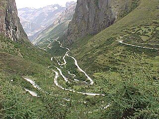
A previously unknown Inca settlement, Quriwayrachina or Quri Wayrachina, was found in the Willkapampa mountain range in the Cusco Region of Peru in 2001. The site lies in the Santa Teresa District of the La Convención Province, north of the archaeological site of Choquequirao and west of the mountains Kiswar and Quriwayrachina (Corihuayrachina), on a mountain named Victoria. Close to nearby ancient Inca mines, the surrounding hills are covered with the littered stones from more than 200 structures in this Inca outpost.

Kimbiri Town in Cusco, Peru

Kimbiri is a town in Southern Peru, capital of the district Kimbiri in the province La Convención in the region Cusco.

Echarate District is one of ten districts of the province La Convención in Peru.

Huayopata District District in Cusco, Peru

Huayopata District is one of ten districts of the province La Convención in Peru.

Ocobamba District is one of ten districts of the province La Convención in Peru.

Quelloúno is one of ten districts of the La Convención Province in the Cusco Region in Peru.

Santa Ana District is one of ten districts of the province La Convención in Peru.

Santa Teresa District District in Cusco, Peru

Santa Teresa District is one of ten districts of the La Convención Province in the Cusco Region of Peru.

Vilcabamba District, La Convención District in Cusco, Peru

Vilcabamba District is one of eleven districts of the La Convención Province in the Cusco Region in Peru.

Megantoni National Sanctuary

Megantoni National Sanctuary is a protected area in Peru situated in the Cusco Region, La Convención Province, Echarate District. It protects a part of the Peruvian Yungas ecoregion.

Veronica (mountain) mountain in Peru

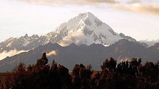
Veronica, also called Huacrahuilki, Huacay Huilcay, Wayna Willka,Waqaywillka, Urubamba, or Padre Eterno, is a 5,893 m (19,334 ft) mountain in the Urubamba mountain range in the Andes of Peru. It is located in the Cusco Region, La Convención Province, Huayopata District, and in the Urubamba Province, Ollantaytambo District northwest of the town of Ollantaytambo.

Huamanmarca, La Convención

Huamanmarca is an archaeological site in the region of Cusco, Peru. It is located in Huayopata District, La Convención Province, on the right bank of the Luq'umayu.

Quriwayrachina may refer to:

Corihuayrachina (Vilcabamba) mountain in Peru

Corihuayrachina erroneously also Corihuaynachina, is a mountain in the Vilcabamba mountain range in the Andes of Peru, about 5,404 metres (17,730 ft) high. It is situated in the Cusco Region, La Convención Province, Vilcabamba District, at a little lake named Corihuayrachina. Corihuayrachina lies south of the Pumasillo massif and west of Padreyoc. The archaeological sites of Corihuayrachina and Choquequirao are west and southwest of the mountain Corihuayrachina.

Inkawasi is one of eleven districts of the La Convención Province in the Cusco Region of Peru. Its seat is Amaybamba. The district was created on November 19, 2014, by Law No. 30265. It is bordered to the north and to the east by the Vilcabamba District of the La Convención Province, to the south by the Huanipaca District of the Abancay Province, and the Pacobamba District of the Andahuaylas Province in the Apurímac Region, and to the west and northwest by the Chungui District of the La Mar Province in the Ayacucho Region. The territory of the Inkawasi District formerly belonged to the Vilcabamba District.

Qayqu may refer to:

Kaiko (mountain) mountain in Peru

Kaiko is a 5,265-metre-high (17,274 ft) mountain in the Vilcabamba mountain range in the Andes of Peru. It is situated in the Cusco Region, La Convención Province, on the border of the districts of Santa Teresa and Vilcabamba. Kaiko lies northeast of Choquetacarpo and northwest of Pumasillo.

Soirococha (Cusco) mountain in Cusco Region, Peru

Soirococha is a 5,297-metre-high (17,379 ft) mountain at a lake of that name in the Vilcabamba mountain range in the Andes of Peru. It is located in the Cusco Region, La Convención Province, Vilcabamba District. Soirococha lies northeast of P'anta and Kima.

References

  1. (in Spanish) Instituto Nacional de Estadística e Informática. Banco de Información Distrital Archived 2008-04-23 at the Wayback Machine .. Retrieved April 11, 2008.
  2. 1 2 "Maranura District - La Convención - Cusco". Promo region cusco. Retrieved 2 July 2014.

Coordinates: 12°57′49″S72°39′50″W / 12.9637°S 72.6639°W / -12.9637; -72.6639

Geographic coordinate system Coordinate system

A geographic coordinate system is a coordinate system that enables every location on Earth to be specified by a set of numbers, letters or symbols. The coordinates are often chosen such that one of the numbers represents a vertical position and two or three of the numbers represent a horizontal position; alternatively, a geographic position may be expressed in a combined three-dimensional Cartesian vector. A common choice of coordinates is latitude, longitude and elevation. To specify a location on a plane requires a map projection.