Layo District

Last updated
Layo
Layu
Vista Panoramica del distrito de Layo.jpg
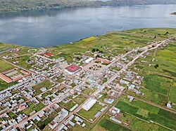
The train the Belmond Andean Explorer [2] at La Raya Station with market stalls and the mountain Chimpulla in the background, Layo District-Santa Rosa District
Location of the district Layo in Canas.svg
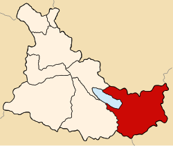
Location of Layo in the Canas province
Country Flag of Peru.svg  Peru
Region Cusco
Province Canas
FoundedJanuary 2, 1857
Capital Layo
Government
   Mayor Alfredo Bustamante Aragón
Gestión (2023-2026)
Area
  Total
452.56 km2 (174.73 sq mi)
Elevation
3,978 m (13,051 ft)
Population
  Total
6,822
  Density15/km2 (39/sq mi)
Time zone UTC-5 (PET)
UBIGEO 080505

Layo District is one of eight districts in the Canas Province in Peru. The seat of the Layo District is the village Layo.

Contents

Geography

The La Raya mountain range traverses the district. Some of the highest mountains of the district are listed below: [3]

Ethnic groups

The people in the district are mainly indigenous citizens of Quechua descent. Quechua is the language which the majority of the population (90.47%) learnt to speak in childhood, 9.39% of the residents started speaking using the Spanish language (2007 Peru Census). [4]

Sources

  1. Belmont
  2. Belmont
  3. escale.minedu.gob.pe - UGEL map of the Melgar Province (Puno Region)
  4. inei.gob.pe Archived 2013-01-27 at the Wayback Machine INEI, Peru, Censos Nacionales 2007, Frequencias: Preguntas de Población

14°30′19″S71°13′31″W / 14.5054°S 71.2253°W / -14.5054; -71.2253