Urubamba District

Last updated
Urubamba
Urupampa
Peru - Trekking from Urubamba 018 (8149152325).jpg
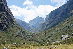
Looking towards Pumawank'a Q'asa
Country Flag of Peru.svg  Peru
Region Cusco
Province Urubamba
Capital Urubamba
Government
   Mayor Luis Valcarcel Villegas
Area
  Total128.28 km2 (49.53 sq mi)
Elevation
2,871 m (9,419 ft)
Population
 (2017)
  Total20,082
  Density160/km2 (410/sq mi)
Time zone UTC-5 (PET)
UBIGEO 081301

Urubamba District is one of seven districts of the Urubamba province in Peru. [1]

Contents

Geography

The Urupampa mountain range traverses the district. One of highest peaks of the district is Ch'iqun at 5,530 m (18,143 ft). Other mountains are listed below: [2]

Climate

Climate data for Urubamba (elevation 2,850 m (9,350 ft), 1991–2020 normals)
MonthJanFebMarAprMayJunJulAugSepOctNovDecYear
Mean daily maximum °C (°F)22.2
(72.0)
22.0
(71.6)
22.3
(72.1)
23.0
(73.4)
23.4
(74.1)
22.8
(73.0)
22.4
(72.3)
23.2
(73.8)
23.6
(74.5)
23.6
(74.5)
23.8
(74.8)
22.7
(72.9)
22.9
(73.3)
Mean daily minimum °C (°F)9.5
(49.1)
9.6
(49.3)
9.2
(48.6)
7.7
(45.9)
5.0
(41.0)
3.1
(37.6)
2.1
(35.8)
3.6
(38.5)
6.0
(42.8)
8.1
(46.6)
8.9
(48.0)
9.3
(48.7)
6.8
(44.3)
Average precipitation mm (inches)105.4
(4.15)
101.3
(3.99)
72.0
(2.83)
22.5
(0.89)
4.1
(0.16)
5.4
(0.21)
5.4
(0.21)
6.7
(0.26)
7.8
(0.31)
38.1
(1.50)
56.4
(2.22)
92.6
(3.65)
517.7
(20.38)
Source: National Meteorology and Hydrology Service of Peru [3]

See also

Related Research Articles

<span class="mw-page-title-main">Calca Province</span> Province in Cusco, Peru

Calca Province is one of thirteen provinces in the Cusco Region in the southern highlands of Peru. Its seat is Calca.

<span class="mw-page-title-main">La Convención Province</span> Province in Cusco, Peru

La Convención Province is the largest of thirteen provinces in the Cusco Region in the southern highlands of Peru.

<span class="mw-page-title-main">Urubamba Province</span> Province in Cusco, Peru

Urubamba Province is one of thirteen provinces in the Cusco Region in the southern highlands of Peru.

<span class="mw-page-title-main">Curahuasi District</span> District in Apurímac, Peru

Curahuasi District is one of the nine districts of the Abancay Province in Peru.

<span class="mw-page-title-main">Abancay District</span> District in Apurímac, Peru

Abancay District is one of the nine districts of the Abancay Province in Peru.

Lambrama District is one of the nine districts of the Abancay Province in Peru. It is located at 13° 52' 32" latitude (south) and 72° 46' 19" latitude (west)

Progreso District is one of the fourteen districts of the Grau Province in Peru.

Mariscal Gamarra District is one of the fourteen districts of the Grau Province in Peru.

Tambobamba is one of the six districts of the Cotabambas Province in Peru.

Coyllurqui District is one of the six districts of the Cotabambas Province in Peru.

Anta District is one of nine districts of the Anta Province in Peru.

<span class="mw-page-title-main">Limatambo District</span> District in Cusco, Peru

Limatambo District is one of nine districts of the province Anta in Peru.

Ccorca District is one of eight districts of the Cusco Province in Peru.

Challabamba District is one of six districts of the Paucartambo Province in Peru.

<span class="mw-page-title-main">Maras District</span> District in Cusco, Peru

Maras District is one of seven districts of the Urubamba Province in Peru. The town of Maras is the capital of the district.

<span class="mw-page-title-main">Ollantaytambo District</span> District in Cusco, Peru

Ollantaytambo District is one of seven districts of the Urubamba province in Peru. The town of Ollantaytambo is the capital of the district.

<span class="mw-page-title-main">Choco District</span> District in Arequipa, Peru

Choco District is one of fourteen districts of the province Castilla in Peru.

Cayarani District is one of eight districts of the province Condesuyos in Peru.

Santiago de Chocorvos District is one of the sixteen districts of the Huaytará province in Peru.

<span class="mw-page-title-main">Jatunjasa (Cusco)</span> Mountain in Peru

Jatunjasa, also known as Incachiriasca, is a 5,338-metre-high (17,513 ft) mountain in the Vilcabamba mountain range in the Andes of Peru. It is located in the Cusco Region, Anta Province, Limatambo District, and in the Urubamba Province, Ollantaytambo District. Jatunjasa lies south of Salcantay.

References

  1. (in Spanish) Instituto Nacional de Estadística e Informática. Banco de Información Distrital Archived 2008-04-23 at the Wayback Machine . Retrieved April 11, 2008.
  2. escale.minedu.gob.pe - UGEL map of the Urubamba Province (Cusco Region)
  3. "Normales Climaticás Estándares y Medias 1991-2020". National Meteorology and Hydrology Service of Peru. Archived from the original on 21 August 2023. Retrieved 25 October 2023.

13°18′20″S72°07′04″W / 13.3056°S 72.1179°W / -13.3056; -72.1179