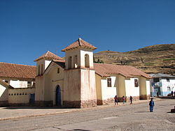
Tinta District

Last updated
Tinta
Tinta 2.jpg
Church in Tinta
Country Flag of Peru.svg  Peru
Region Cusco
Province Canchis
Capital Tinta
Government
   Mayor Angel Gabino Manya Zavaleta
Area
  Total79.39 km2 (30.65 sq mi)
Elevation
3,466 m (11,371 ft)
Population
  Total6,152
  Density77/km2 (200/sq mi)
Time zone UTC-5 (PET)
UBIGEO 080608

Tinta District is one of eight districts of the Canchis Province in Peru. [1]

Contents

Geography

The most important river of the district is the Willkanuta which crosses the district from south-east to north-west. [2]

Ethnic groups

The people in the district are mainly indigenous citizens of Quechua descent. Quechua is the language which the majority of the population (75.37%) learnt to speak in childhood, 24.33% of the residents started speaking using the Spanish language (2007 Peru Census). [3]

See also

Related Research Articles

<span class="mw-page-title-main">Checca District</span> District in Cusco, Peru

Checca District is the largest of eight districts in the Canas Province in Peru. Its seat is Checca.

<span class="mw-page-title-main">Kunturkanki District</span> District in Cusco, Peru

Kunturkanki District is one of eight districts in the Canas Province in Peru. Its seat is the village of El Descanso.

<span class="mw-page-title-main">Langui District</span> District in Cusco, Peru

Langui District is one of eight districts in the Canas Province in Peru. Its seat is the village of Langui.

Acopia District is one of seven districts of the province Acomayo in Peru.

Acos District is one of seven districts of the Acomayo Province in Peru.

Mosoc Llacta is one of seven districts of the province Acomayo in Peru.

Pomacanchi District is one of seven districts of the Acomayo Province in Peru.

<span class="mw-page-title-main">Lamay District</span> District in Cusco, Peru

Lamay District is one of eight districts of the province Calca in Peru.

<span class="mw-page-title-main">Taray District</span> District in Cusco, Peru

Taray District is one of eight districts of the Calca Province in the Cusco Region in Peru. Its seat is Taray. The town lies near Pisac, southwest of it, at a stream called Pawayuq (Pahuayoc), an affluent of Willkanuta River.

Checacupe or Ch'iqa Kupi is one of eight districts of the Canchis Province in the Cusco Region in Peru.

Combapata District is one of eight districts of the province Canchis in Peru.

<span class="mw-page-title-main">Marangani District</span> District in Cusco, Peru

Marangani District is one of eight districts of the province Canchis in Peru.

<span class="mw-page-title-main">Pitumarca District</span> District in Cusco, Peru

Pitumarca District is one of eight districts of the province Canchis in Peru.

San Pablo District is one of eight districts of the province Canchis in Peru.

San Pedro District is one of eight districts of the province Canchis in Peru.

<span class="mw-page-title-main">Chamaca District</span> District in Cusco, Peru

Chamaca is one of eight districts of the Chumbivilcas Province in Peru.

<span class="mw-page-title-main">Alto Pichigua District</span> District in Cusco, Peru

Alto Pichigua District is one of eight districts of the Espinar Province in Peru.

Condoroma District is one of eight districts of the province Espinar in Peru.

Pichigua District is one of eight districts of the Espinar Province in Peru.

Caicay District is one of six districts of the province Paucartambo in Peru.

References

  1. (in Spanish) Instituto Nacional de Estadística e Informática. Banco de Información Distrital Archived 2008-04-23 at the Wayback Machine . Retrieved April 11, 2008.
  2. escale.minedu.gob.pe - UGEL maps of the Canchis Province (Cusco Region)
  3. inei.gob.pe Archived 2013-01-27 at the Wayback Machine INEI, Peru, Censos Nacionales 2007, Frequencias: Preguntas de Población: Idioma o lengua con el que aprendió hablar (in Spanish)

14°08′38″S71°24′20″W / 14.1440°S 71.4055°W / -14.1440; -71.4055