Tinta, Cuzco

Last updated

Tinta
Locality
Tinta 2.jpg
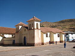
St. Bartholomew's Church within the town
Peru location map.svg
Red pog.svg
Tinta
Coordinates: 14°08′40″S71°24′20″W / 14.14444°S 71.40556°W / -14.14444; -71.40556
Country Flag of Peru.svg  Peru
Department Cuzco
Province Canchis
District Tinta
Elevation
3,836 m (12,585 ft)
Population
 (2017)
  Total2,910
Time zone UTC-5 (PET)

Tinta is the capital town of Tinta District, Canchis Province, Department of Cuzco, Peru. It is located at an altitude of 3,836 meters above the sea level. [1] As of the year 2017, it had a total population of 2,910. [2]

Contents

Climate

Tinta has a Tundra Climate (ET) under the Köppen Climate Classification. It sees the most precipitation in January, with an average rainfall of 239 mm; and the least precipitation in July, with an average rainfall of 15 mm.

Climate data for Tinta
MonthJanFebMarAprMayJunJulAugSepOctNovDecYear
Average high °C (°F)12.8
(55.0)
12.7
(54.9)
12.9
(55.2)
12.7
(54.9)
12.4
(54.3)
12.3
(54.1)
12.2
(54.0)
13.4
(56.1)
14.0
(57.2)
14.1
(57.4)
14.1
(57.4)
13.3
(55.9)
13.1
(55.5)
Daily mean °C (°F)8.0
(46.4)
8.0
(46.4)
8.0
(46.4)
7.5
(45.5)
6.8
(44.2)
6.0
(42.8)
5.6
(42.1)
6.4
(43.5)
7.5
(45.5)
8.2
(46.8)
8.6
(47.5)
8.3
(46.9)
7.4
(45.3)
Average low °C (°F)4.3
(39.7)
4.3
(39.7)
4.0
(39.2)
2.8
(37.0)
1.2
(34.2)
0.1
(32.2)
−0.6
(30.9)
−0.1
(31.8)
1.5
(34.7)
3.1
(37.6)
3.8
(38.8)
4.3
(39.7)
2.4
(36.3)
Average rainfall mm (inches)239
(9.4)
221
(8.7)
195
(7.7)
95
(3.7)
34
(1.3)
16
(0.6)
15
(0.6)
26
(1.0)
55
(2.2)
112
(4.4)
140
(5.5)
196
(7.7)
1,344
(52.8)
Source: Climate-Data.org [3]

See also

Related Research Articles

<span class="mw-page-title-main">Ayer Tawar</span> Town in Perak, Malaysia

Ayer Tawar is a town in Manjung District, Perak, Malaysia. Its name came from Air Tawar, which literally means "fresh water" in the Malay language. As of the year 2020, it has a total population of 3,050.

Tando Jam is a town and a municipal committee of Hyderabad District in the Sindh province of Pakistan. It lies on the east of Hyderabad Taluka, about 12 kilometres northeast of the city center. As of 2017, Its population is 71,760.

Adavad, also spelled Adawad or Adwad, is a village in the Chopda Tehsil of Jalgaon District, Maharashtra, India. It is situated at the southern base of the Satpura Hills, about 30 kilometres northwest of the district seat Jalgaon, and 13 kilometres east of the subdistrict seat Chopda. As of the year 2011, it has a total population of 24,357.

Nitte is a village in Karkala Taluk, Udupi District, Karnataka, India. It is located on the way from Padubidri to Karkala, about 26 kilometres southeast of the district capital Udupi, and 7 kilometres southwest of the taluka capital Karkala. In the year 2011, the village is home to 12,354 inhabitants.

<span class="mw-page-title-main">Wandoor, Kerala</span> Town in Kerala, India

Wandoor is a town in Nilambur Taluk, Malappuram District, Kerala, India. It is located on the southeast of Chaliyar River, about 24 kilometres northeast of the district seat Malappuram, and 8 km south of the taluk seat Nilambur. In the year 2011, the town has a population of 50,973.

<span class="mw-page-title-main">Lorcha, Spain</span> Municipality in Alicante, Spain

Lorcha, or L'Orxa, is a municipality in the comarca of Comtat in the Valencian Community, Spain. As of the year 2021, it has a total population of 581.

<span class="mw-page-title-main">Ihuatzio</span> Locality in Michoacán, Mexico

Ihuatzio, which translates to "Land of Coyotes" in the Purépecha language, is a town located near Lake Pátzcuaro in the Mexican state of Michoacán. It was once the capital of the Purépecha kingdom. It was the capital until the change to Tzintzuntzan. As of the year 2020, it has a total population of 3,950.

<span class="mw-page-title-main">Güicán</span> Municipality in the department of Boyacá, Colombia

Güicán de la Sierra, also known as Nuestra Señora de la Candelaria de Güicán, is a town and municipality in the Colombian Department of Boyacá. It is close to the national natural park El Cocuy National Park. As of the year 2020, it has a total population of 6,426.

Chinchali is a village in Raybag Taluk, Belagavi District, Karnataka, India. It is located near the state boundary with Maharashtra, approximately 84 kilometres north of the district seat Belgaum, and 10 kilometres northeast of the taluk seat Raibag. In the year 2011, the village has a population of 18,986.

Nazarezinho is a municipality in the state of Paraíba in the Northeast Region of Brazil. As of the year 2021, its total population is 7,271.

Cedral is a town and municipality in the Mexican state of San Luis Potosí in central Mexico. As of the year 2020, it has a total population of 19,840.

Mohare is a village in Bailhongal Taluk, Belagavi District of Karnataka, India. It is located near the state border with Maharashtra, about 26 kilometres east of the district seat Belgaum, and 16 kilometres northwest of the taluk seat Bailhongal. As of 2011, it has a total population of 2,365.

Parham is a village in Jasrana Tehsil, Firozabad District, Uttar Pradesh, India. As of the year 2011, it has a population of 19,642.

Narmada is a kecamatan in West Lombok Regency, West Nusa Tenggara, Indonesia. It is located on the west side of the island Lombok, approximately 10 kilometers east of Mataram. In 2022, its population was 104,100.

<span class="mw-page-title-main">Joachín, Veracruz</span> Town in Veracruz, Mexico

Joachín is a locality in Tierra Blanca, Veracruz, Mexico. It is located in the Papaloapan region, about 31 kilometers northeast of Tierra Blanca. The town is located at an average elevation of 36 meters above the sea level. As of the year 2020, it had a population of 2,623.

Gutin is a town in Gida Kiremu, East Welega Zone, Oromia Region, Ethiopia. The town is located to the north of Didesa River and west of Hanger Wenz River, with an elevation of 1,358 meters above the sea level. As of 2022, it had a total population of 28,300.

Coipasa is a rural municipality in Sabaya Province, Oruro Department, Bolivia. It is surrounded by Coipasa Lake on three directions, and has an average elevation of 3,709 meters above the sea level.

Mogna is a town in the Jáchal Department, San Juan Province, Argentina. It is located on the right bank of the Jáchal River, at an altitude of 734 meters above the sea level. In the year 2010, the town had a total population of 114.

<span class="mw-page-title-main">Mali Chornokintsi</span> Village in Ternopil Oblast, Ukraine

Mali Chornokintsi is a village in Kolydinay rural hromada, Chortkiv Raion, Ternopil Oblast, Ukraine. As of 2018, the village has a population of 411.

<span class="mw-page-title-main">Pietreni, Constanța</span> Village in Constanța, Romania

Pietreni, formerly known as Cocargea, is a village in Deleni Commune, Constanța County, Romania. In the 2021 census, it had a population of 799.

References

  1. "Tinta topographic map, elevation, terrain". Topographic maps. Retrieved 9 August 2023.
  2. "Tinta (Canchis, Cusco Region, Peru) - Population Statistics, Charts, Map, Location, Weather and Web Information". www.citypopulation.de. Retrieved 9 August 2023.
  3. "Tinta climate: Temperature Tinta & Weather By Month - Climate-Data.org". en.climate-data.org. Retrieved 9 August 2023.