Coya District

Last updated
Coya
Urubambadalen-IMG 6901.JPG
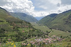
The Willkanuta valley in the Coya District (background) as seen from Taray
Coya District
Country Flag of Peru.svg  Peru
Region Cusco
Province Calca
FoundedSeptember 11, 1951
Capital Coya
Government
   Mayor Lizardo Emilio Palomino Ricalde
Area
  Total
71.43 km2 (27.58 sq mi)
Elevation
2,951 m (9,682 ft)
Population
  Total
3,698
  Density52/km2 (130/sq mi)
Time zone UTC-5 (PET)
UBIGEO 080402

Coya District is one of eight districts of the Calca Province in the Cusco Region of Peru. [1]

Contents

Geography

Some of the highest mountains of the district are listed below: [2]

Ethnic groups

The people in the district are mainly indigenous citizens of Quechua descent. Quechua is the language which the majority of the population (79.19%) learnt to speak in childhood, 20.66% of the residents started speaking using the Spanish language (2007 Peru Census). [3]

See also

References

  1. (in Spanish) Instituto Nacional de Estadística e Informática. Banco de Información Distrital Archived April 23, 2008, at the Wayback Machine . Retrieved April 11, 2008.
  2. escale.minedu.gob.pe - UGEL map of the Calca Province and the Cusco Province (Cusco Region)
  3. inei.gob.pe Archived January 27, 2013, at the Wayback Machine INEI, Peru, Censos Nacionales 2007, Frequencias: Preguntas de Población

13°23′15″S71°54′00″W / 13.3875°S 71.8999°W / -13.3875; -71.8999