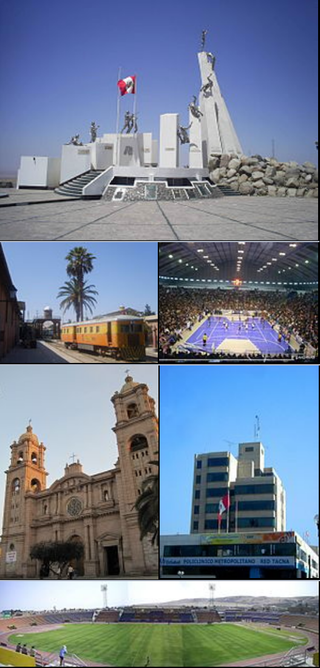
Tacna, officially known as San Pedro de Tacna, is a city in southern Peru and the regional capital of the Tacna Region. A very commercially active city, it is located only 35 km (22 mi) north of the border with Arica y Parinacota Region from Chile, inland from the Pacific Ocean and in the valley of the Caplina River. It is Peru's tenth most populous city.
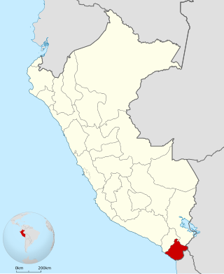
Tacna is the southernmost department and region in Peru. The Chilean Army occupied the present-day Tacna Department during the War of the Pacific from 1885 until 1929 when it was reincorporated into Peru.

The Alto de la Alianza Monumental Complex is a historical monument and landmark complex in the south of Peru, near the city of Tacna.

Rail transport in Peru has a varied history. Peruvian rail transport has never formed a true network, primarily comprising separate lines running inland from the coast and built according to freight need rather than passenger need.

Incahuasi is a volcanic mountain in the Andes of South America. It lies on the border of the Catamarca Province of Argentina and the Atacama Region of Chile. Incahuasi has a summit elevation of 6,621 metres (21,722 ft) above sea level.

The Battle of Tacna, also known as the Battle of the Peak of the Alliance, effectively destroyed the Peru-Bolivian alliance against Chile, forged by a secret treaty signed in 1873. On May 26, 1880, the Chilean Northern Operations Army led by General Manuel Baquedano González, conclusively defeated the combined armies of Peru and Bolivia commanded by Bolivian President, General Narciso Campero. The battle took place at the Inti Urqu (Intiorko) hill plateau, a few miles north of the Peruvian city of Tacna. As a result, Bolivia was knocked out of the war, leaving Peru to fight the rest of the war alone. Also, this victory consolidated the Chilean domain over the Tarapacá Department. The territory was definitively annexed to Chile after the signing of the Tratado de Ancón, in 1884, which ended the war. Tacna itself remained under Chilean control until 1929.
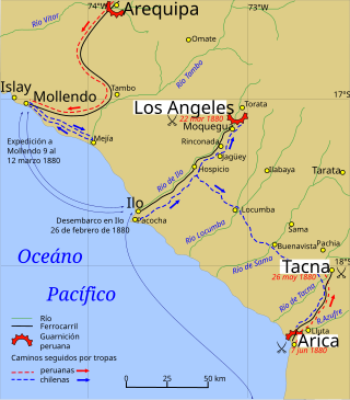
The Tacna and Arica campaign is known as the stage of the War of the Pacific after the Chilean conquest of the Peruvian department of Tarapacá, ending with Chilean domination of the Moquegua department in southern Peru. During this campaign Bolivia retired from the war after the Battle of Tacna, and Peru lost the port of Arica. Also, Manuel Baquedano assumed command as the new Commander in Chief of the Chilean Army, and the Allied Presidents were thrown out of office and replaced by Nicolas de Pierola in Peru and General Narciso Campero in Bolivia.

The Treaty of Peace and Friendship of 1904 between Chile and Bolivia was signed in Santiago de Chile on October 20, 1904, to delineate the boundary through 96 specified points between Cerro Zapaleri and Cerro Chipe and to regulate the relations between the two countries 20 years after the end of the War of the Pacific.

Yucamane, Yucamani or Yucumane is an andesitic stratovolcano in the Tacna Region of southern Peru. It is part of the Peruvian segment of the Central Volcanic Zone, one of the three volcanic belts of the Andes generated by the subduction of the Nazca plate beneath the South America plate. Peru's active volcanoes Ubinas, Sabancaya and El Misti are also part of the Central Volcanic Zone.
The Tacna Parabolic Arch is a monument located in the Paseo Civico, in the center of the city of Tacna, Peru. It was raised in honor of the heroes of the War of the Pacific, like Admiral Miguel Grau and Colonel Francisco Bolognesi. Its construction is made of quarried pink stone. Ex-president Manuel Prado inaugurated it.
Canal Mauri is a canal in Peru and Chile. It transfers water from the Mauri River watershed and transfers it into the Caplina River for irrigation purposes. An earlier canal Canal Uchusuma was constructed in the early 19th century and was replaced by the Canal Mauri. This canal collects water from several tributaries of the Mauri River and diverts it through Chilean territory into the Quebrada Vilavilani, a tributary of the Caplina River; from there it is later diverted for irrigation purposes in the Tacna region.

Tutupaca is a volcano in the region of Tacna in Peru. It is part of the Peruvian segment of the Central Volcanic Zone, one of several volcanic belts in the Andes. Tutupaca consists of three overlapping volcanoes formed by lava flows and lava domes made out of andesite and dacite, which grew on top of older volcanic rocks. The highest of these is usually reported to be 5,815 metres (19,078 ft) tall and was glaciated in the past.

Sara Sara is a 5,505-metre-high (18,061 ft) volcano lying between Lake Parinacochas and the Ocoña River in Peru. It is situated in the Parinacochas Province and the Paucar del Sara Sara Province. The volcano formed during the Pleistocene during four different stages of volcanic activity, which constructed a volcanic edifice with an oval outline consisting of lava flows and lava domes. The volcano was glaciated during the last glacial maximum; it may still feature glaciers. The last eruption was about 14,000 years ago and future eruptions are possible. The volcano was worshipped by the local population, and an Inca mummy of a 15-year old girl was found on the summit by archaeologists.

Chachani is a volcanic group in southern Peru, 22 kilometres (14 mi) northwest of the city of Arequipa. Part of the Central Volcanic Zone of the Andes, it is 6,057 metres (19,872 ft) above sea level. It consists of several lava domes and individual volcanoes such as Nocarane, along with lava shields such as the Airport Domes. Underneath Chachani lies a caldera.
Purupuruni is a group of lava domes in southern Peru and a correlative geological formation. They are among the many volcanoes that exist in Peru and whose activity has been associated with the subduction of the Nazca Plate beneath the South America Plate. Purupuruni is associated with a geothermal field and a caldera. Volcanic activity occurred during the Pleistocene 53,000 ± 8,000 years ago but also during the Holocene about 5,300 ± 1,100 years ago; today the volcano is considered to be a low hazard volcano but is being monitored nevertheless.

Casiri, also known as Paucarani, is an about 5,650 metres (18,537 ft) high complex volcano in the Barroso mountain range of the Andes, in the Tacna Region of Peru. It consists of four individual volcanic edifices with lava domes; the southeasternmost edifice has been active during the Holocene, producing thick lava flows that have overrun moraines of Pleistocene age. The youngest lava flow has been dated to 2,600 ± 400 years ago. Although no historical eruptions are known, the volcano is considered to be potentially active and is monitored.

The Tacna Prefecture, also known as the Tacna Intendancy, is a building located in the homonymous city in Peru. It was built and used by Chile under its administration of its former Tacna Province until its return to Peru in 1929.

The Chilean–Peruvian territorial dispute is a territorial dispute between Chile and Peru that started in the aftermath of the War of the Pacific and ended significantly in 1929 with the signing of the Treaty of Lima and in 2014 with a ruling by the International Court of Justice. The dispute applies since 2014 to a 37,610 km2 territory in the Chile–Peru border, as a result of the maritime dispute between both states.

The Alto de la Alianza Museum is a war museum located at the Alto de la Alianza, near Tacna, in southern Peru. It was inaugurated on May 26, 1982.

The Crypt of Heroes is a war monument located at Intiorko Hill, Tacna, Peru. Originally inaugurated by the Chilean administration in 1901 and rededicated in 1930 by the Peruvian government, the monument is currently partially destroyed.
