Official name: Remnants of Ipswich Town Wharves, Australasian Steam Navigation Wharf and William Collins and Son Wharf, J & G Harris Wharf, Walter Gray and Co Wharf
Type
state heritage (archaeological)
Designated
31 July 2006
Referenceno.
602567
Significant period
1840s-1920s (fabric, historical)
Significant components
wall/s - retaining, pile/s, artefact field
Ipswich Town Wharves are heritage-listed remants of wharves beside the Bremer River at Bremer Street, North Ipswich, City of Ipswich, Queensland, Australia. They were built from 1847 to c.1927. They were also known as Australasian Steam Navigation Wharf and William Collins and Son Wharf, J & G Harris Wharf, and Walter Gray and Co Wharf. They were added to the Queensland Heritage Register on 31 July 2006.[1]
The Bremer River is a river that is a tributary of the Brisbane River, located in the Scenic Rim and Brisbane regions of South East Queensland, Australia. The 100-kilometre (62 mi)-long Bremer River drains several Scenic Rim valleys in south-east Queensland, including the Fassifern Valley, with its catchment area covering approximately 2,032 square kilometres (785 sq mi). Most valleys within the catchment have extensive river terraces. The Bremer River system is extremely degraded.
North Ipswich is a suburb of Ipswich, Queensland, Australia. At the 2011 census the suburb recorded a population of 4,587.
The City of Ipswich is a local government area in Queensland, Australia, located in the southwest of the Brisbane metropolitan area, including the urban area surrounding the city of Ipswich and surrounding rural areas.
The remnants of Ipswich Town Wharves are an archaeological site that contains visible remains of two wharves. Horizontal timbers extending from the riverbank, together with an associated stone wall are probably the remnants of the Australasian Steam Navigation Wharf (c.1867). Vertical piles projecting out of the river a short distance downstream are probably the remains of the J and G Harris landing (ca1862). The site was also the location of a wharf owned by Walter Gray & Co (1847 - c.1862) and was used by William Collins and Son in the first part of the twentieth century. Archaeological deposits originating from the wharves also exist on the riverbed.[1]
Ipswich commenced as a convict outstation known as "Limestone" in 1827. After free settlement began in 1842, the township developed as an important regional centre because of its location at the head of navigation of the Brisbane and Bremer Rivers and at the junction of routes to the Brisbane Valley and the Darling Downs. Goods from these regions were channelled through Ipswich en route to the coast and this trade contributed significantly to Ipswich's rapid growth and prosperity.[1]
Ipswich is an urban region in south-east Queensland, Australia, which is located in the south-west of the Brisbane metropolitan area. Situated on the Bremer River, it is approximately 40 kilometres (25 mi) west of the Brisbane CBD. A local government area, the City of Ipswich has a population of 200,000. The city is renowned for its architectural, natural and cultural heritage. Ipswich preserves and operates from many of its historical buildings, with more than 6000 heritage-listed sites and over 500 parks. Ipswich began in 1827 as a mining settlement.
The Brisbane River is the longest river in South East Queensland, Australia, and flows through the city of Brisbane, before emptying into Moreton Bay. John Oxley, the first European to explore the river, named it after the Governor of New South Wales, Sir Thomas Brisbane in 1823. The penal colony of Moreton Bay later adopted the same name, eventually becoming the present city of Brisbane.
The Darling Downs is a farming region on the western slopes of the Great Dividing Range in southern Queensland, Australia. The Downs are to the west of South East Queensland and are one of the major regions of Queensland. The name was generally applied to an area approximating to that of the Condamine River catchment upstream of Condamine township but is now applied to a wider region comprising the Southern Downs, Western Downs, Toowoomba and Goondiwindi local authority areas. The name Darling Downs was given in 1827 by Allan Cunningham, the first European explorer to reach the area and recognises the then Governor of New South Wales, Ralph Darling.
The people of Ipswich, together with the Darling Downs pastoralists wielded considerable political influence and agitated for Ipswich, rather than Brisbane, to be made the colony's capital. One of the key factors in favour of Ipswich was its role as an inland port. It was argued that goods could be shipped from Ipswich directly to Moreton Bay, by-passing Brisbane.[1]
The Moreton Bay is a bay located on the eastern coast of Australia 14 kilometres (8.7 mi) from central Brisbane, Queensland. It is one of Queensland's most important coastal resources. The waters of Moreton Bay are a popular destination for recreational anglers and are used by commercial operators who provide seafood to market.
There were sound practical reasons why this was a viable proposition. Poor road conditions meant that it was more convenient for the pastoralists to transport bulk goods from Ipswich to the coast along the Bremer and Brisbane Rivers using riverboats. This meant that goods had to be transferred from the riverboats to ocean-going vessels in Moreton Bay but this was necessary even for goods shipped from Brisbane because the Brisbane Bar prevented large vessels entering the river.[1]
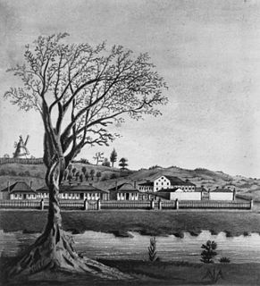
A pastoralist, James Pearce, started the first steamer service from Ipswich in 1846 using the vessel, Experiment. In 1848, a committee of townspeople was formed to upgrade the Ipswich "landing place" to a proper wharf with improved road access. By the 1860s a wharf precinct had developed between the present location of the railway bridge and The Basin, a section of the Bremer River downstream from the town centre that was wide enough to permit steamers to turn.[1]
River trade peaked in the 1860s and 1870s, especially after Ipswich became the eastern rail terminus. In 1860, the Port of Moreton Bay was extended to Ipswich. At least six wharves lined the south bank of the Bremer between The Basin and the bridge. The wharves were linked to large stores built along the north side of Bremer Street. Bales of wool and cotton were slid down chutes to smaller wharf-side sheds. The wharf remnants presently located on the site were once among the largest and most important in the precinct.[1]
Walter Gray's wharf, which was located at Site One, was one of the first wharves to be established in the precinct. In 1847, Gray, a Scottish immigrant, occupied a block of land that extended from Bremer Street to the riverbank at Site One. He commenced business as a general storekeeper and agent trading in wool and other produce which he conveyed to Brisbane using Reid and Boyland's punts. His business reputedly became the largest mercantile house in the district operating extensive stores capable of holding several hundred bales of wool.[1]
Gray became a prominent member of the Ipswich community. He was treasurer of the committee of Ipswich businessmen that built the Ipswich town wharf in 1848. He supported establishing Cleveland as the colony's main port and, in the 1850s, together with other Ipswich businessmen, bought land and signified his intention to build jetties there where punts could load and unload cargoes. Gray promoted cotton cultivation and was a shareholder and director of the Ipswich Cotton Company. In 1860 when the Port of Moreton Bay was extended to Ipswich, his facilities were licensed as the bonded store where dutiable goods could be stored.[1]
In 1856, a surveyor described the wharf as "not a properly built wharf, but more of an earth bank". Associated facilities included a shed enclosed on one side with bark near the river, a slab and shingle wool store higher up the bank, a wooden slide down to the wharf from the store, and a road "cut into the bank and made with stone". By 1861, wool presses, at least one of which was steam powered, were located on either side of the stores fronting Bremer Street. A steam-powered cotton gin was added, probably in early 1862. Gray also had a store on the corner of Bell and Bremer Streets.[1]
Walter Gray died in 1862 and, by 1865, John and George Harris, merchants and agents from Brisbane, had taken over the wharf site. Harris's and Gray had jointly acted as agents for at least one ocean- going ship just prior to his death. J and G Harris built a large brick store on the southern side of Bremer Street on the Bell Street corner opposite the wharf. They probably also upgraded the wharf to a more substantial timber landing with a new wharf-side shed in the early 1860s. The upstream side of the new shed was shaped in a "v" configuration to withstand water pressure on the regular occasions that the Bremer flooded the site. In 1867 J & G Harris was paying rent for a water frontage of 130 feet (39.6m). This was the third largest frontage in the precinct. Harris's appears to have ceased operation at the site by 1878 when they applied to the Ipswich Town Clerk to remove their buildings.[1]
The Australasian Steam Navigation Company (ASN) wharf was established next to Gray's wharf between 1856 and 1861. ASN had an interest in the Ipswich shipping trade as early as 1856 when Gray acted as their agent. In 1860 they launched a steamer, Ipswich, specifically for trade between Brisbane and Ipswich. By July 1861, the company had acquired the site next to Gray's and had completed improvements on it.[1]
Originally formed in Sydney in 1839/40 as The Hunter's River Steam Navigation Company, ASN had become the principal shipping firm in the Australian coastal trade by the 1850s. The company commenced a regular service to Moreton Bay when it opened to free settlement in 1842 and in 1844 they established their first wharf facility in Brisbane. The company's activities contributed significantly to the expansion of settlement in Queensland.[1]
Initially, the ASN wharf was a small timber wharf or an "earth bank" similar to Gray's wharf. A shed was located immediately adjacent to the wharf and a store fronted Bremer Street. A slide linked the wharf-side shed and the store.[1]
ASN rebuilt most of their wharf facilities in 1867 after a flood had destroyed their earlier buildings. A new 90 feet (27.4m) long shed was built next to the wharf. 50 feet (15.2m) of this was partitioned off for customs use. The walls were 10 feet (3m) high and the centre beam, 17 feet (5.1m) high. The structure was fastened with iron ties and braces and roofed with galvanised iron. Like Harris's shed, the upstream wall was shaped in a "v" configuration to deflect floodwaters. A new wharf was also built at this time. In 1867, ASN were paying rent for a river frontage of 163 feet (49.7m), the largest in the precinct. ASN had probably ceased operations from the Ipswich wharf by 1874 and in 1879 their wharf lease terminated.[1]
After 1875 when the rail link to Brisbane was opened, the period of intense riverboat activity ended. A partial revival of river trade occurred in the 1890s probably due in part to the lack of a rail link to Brisbane after the loss of the Albert Bridge at Indooroopilly in the 1893 flood. However, the economic and political motives that had stimulated the trade in the 1860s and 1870s no longer existed and it became difficult to justify expending money on keeping the river route viable.[1]
Nevertheless, two commercial river services operated in the early 20th Century from the site. In 1903 William Collins & Son used a wharf next to the remains of Harris's wharf. Collins operated a number of vessels between Brisbane and Ipswich including the Mary, Eucalypta, Essex, Myora and Advance. A "stiff legged" timber crane was used to unload goods at the wharf. Increasingly unable to compete with road transport, Collins ceased the river service cira 1927.[1]
In 1932 Percy Manders commenced trading using the 40 feet (12m) cargo vessel MV Eclipse. Manders made three trips weekly carrying 18 - 20 tonnes of all kinds of merchandise. He initially used the former Collins wharf and crane.[1]
Virtually no further development took place at the site from the time of Manders' operation until 2006 when the area was landscaped as part of the River Terraces development.[1]
Prior to this development, in January 2006, archaeological surveys were completed at the sites. These surveys mapped the remains of the wharves and recovered artefacts.[1]
Description
The wharf remains are located in the River Terraces development at Ipswich, between the railway bridge and the David Trumpy road bridge.[1]
An associated artefact field on the riverbed extends up to 18 m downstream from the downstream pile and upstream merges into the artefact field associated with Site 2. It extends up to 12m into the river channel.[1]
Site 2
The central position of this site is approximately 27°36′39″S152°45′37″E / 27.61083°S 152.76028°E / -27.61083; 152.76028 (Ipswich Town Wharves, Site 2). Three timber bearers measuring about 30cm in diameter project up to 2.9m horizontally from the riverbank. The outer ends are modified (scarfed) on the underside to enable them to sit onto piles or a wharf head. The timber may be turpentine. A stone wall underneath these bearers is built into the riverbank. This wall is covered at high tide.[1]
An associated artefact field extends upstream from the site and downstream merges with artefacts associated with site 1. The field extends up to 17m into the river channel.[1]
Heritage listing
Remnants of Ipswich Town Wharves was listed on the Queensland Heritage Register on 31 July 2006 having satisfied the following criteria.[1]
The place is important in demonstrating the evolution or pattern of Queensland's history.
The Remnants of Ipswich Town Wharves on the town reach of the Bremer River, are important in demonstrating the evolution of Queensland's history insofar that they are surviving evidence of the important early river commerce between Ipswich and the coast. Ipswich was one of the first river ports to be established in the colony. As the westernmost point of access to Moreton Bay via the Bremer and Brisbane Rivers, the town was a major port for the Darling Downs and West Moreton until the railway opened to Brisbane in 1875. During this period, the Bremer and Brisbane Rivers below Ipswich constituted one of the most important mercantile routes in the colony. The wharf remnants are evidence of this commerce and Ipswich's key role in it. The wharf remnants are also physical evidence of an important aspect of the historical rivalry between Ipswich and Brisbane. The river trade, in which the wharves played a vital role, underpinned Ipswich's rapid growth and prosperity and was the key to its viability as an alternative export port to Brisbane. The river commerce was an important factor in the town's bid to become the colony's capital.[1]
The place demonstrates rare, uncommon or endangered aspects of Queensland's cultural heritage.
The Remnants are rare as surviving physical evidence of the early commerce between Ipswich and the coast along the Bremer River and Brisbane Rivers. There are no other known remains of this important early trade route. The remnants of the wharves are uncommon insofar that they constitute a largely undisturbed archaeological site in an urban setting. The site functioned as a wharf precinct from the 1840s until at least the 1930s. From that period until 2006, no significant built development took place on the riverbank or in the river.[1]
The place has potential to yield information that will contribute to an understanding of Queensland's history.
As an archaeological site, the remnants of the wharves have the potential to yield information that will contribute to an understanding of the historical river trade along the Bremer and Brisbane Rivers and Ipswich's role in this. They also have the potential to contribute to our knowledge of trade to and from the Darling Downs and West Moreton, regions that made an important contribution to the development of Queensland. Most of the goods being conveyed to or from these areas prior to 1875 were channelled through the Ipswich wharves.The site has the potential to contribute to our knowledge of the Australasian Steam Navigation Company (ASN). An ASN wharf occupied the site from ca 1861 to ca 1874. ASN was the principal shipping firm in the Australian coastal trade by the 1850s. Its activities contributed significantly to the expansion of settlement in Queensland.[1]
Related Research Articles
Bulimba ferry wharf is a heritage-listed ferry wharf at Oxford Street, Bulimba, City of Brisbane, Queensland, Australia. It is located on the southern side of the Brisbane River serving the Brisbane suburb of Bulimba. It is served by Transdev Brisbane Ferries' CityCat service and the cross-river service to Teneriffe. It was designed by GHM Addison and Son and built in 1922 by E Taylor. It is also known as Bulimba ferry house and Bulimba waiting shed & landing. It was added to the Queensland Heritage Register on 12 January 2003.
The Brisbane Valley railway line was a railway connection in Queensland, Australia connecting Ipswich, west of Brisbane, to the upper Brisbane River valley. Progressively opened between 1884 and 1913 the railway provided a vital transport link between Ipswich and Yarraman and forged development and prosperity along its path. The line acquired its serpentine reputation because it did not take a straight course when faced with a hill or gully.
Howard Smith Wharves is a heritage-listed wharf on the Brisbane River at Boundary Street, Brisbane City and Fortitude Valley, City of Brisbane, Queensland, Australia. It was built from c. 1934 to 1940s circa. It is also known as Brisbane Central Wharves. The 3.5-hectare (8.6-acre) site is one of the most culturally and historically significant riverfront locations in Brisbane. It was added to the Queensland Heritage Register on 4 February 1997.
Naldham House is a heritage-listed office building located at 193 Mary Street, Brisbane CBD, City of Brisbane, Queensland, Australia. It was built from 1864 to 1889. It is also known as AUSN House. It was added to the Queensland Heritage Register on 21 October 1992.
Queensland Woollen Manufacturing Company mill is a heritage-listed mill at 42 & 42B The Terrace, North Ipswich, City of Ipswich, Queensland, Australia. It is also known as Australian Fabric Manufacturers Ltd and Boral Hancock Plywood. It was added to the Queensland Heritage Register on 19 September 2008.
The South Brisbane Railway Easement is the heritage-listed remnants of a former railway branch line and siding at 412 Stanley Street, South Brisbane, Queensland, Australia. It was built from 1882 to 1897. It is also known as Dry Dock Siding, South Brisbane Wharves Extension, and Stanley Street Terminus. It was added to the Queensland Heritage Register on 21 October 1992.
Langshaw Marble Lime Works is a heritage-listed remains of a former lime kiln at 12 Julius Street, New Farm, City of Brisbane, Queensland, Australia. It was built from c. 1878 to c. 1881. It was added to the Queensland Heritage Register on 13 October 1997.
The Early Streets of Brisbane is a heritage-listed archaeological site at sections of Albert Street, George Street, William Street, North Quay, Queen's Wharf Road, Brisbane City, City of Brisbane, Queensland, Australia. It was built from 1825 onwards. It was added to the Queensland Heritage Register on 16 July 2010.
Heiner Road Railway Overpass is a heritage-listed road bridge within the Riverlink Shopping Centre at 2 Downs Street, North Ipswich, City of Ipswich, Queensland, Australia. It was built in 1865. It was added to the Queensland Heritage Register on 28 May 2004.
The Mihi Creek heritage site is a heritage-listed archaeological site at Mihi Junction, Brassall, City of Ipswich, Queensland, Australia. It is also known as Mihi Junction and Mi Hi Creek. It was added to the Queensland Heritage Register on 16 July 2010.
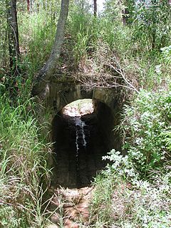
Sandstone Railway Culvert is a heritage-listed culvert at about 130 metres (430 ft) west of the corner of WM Hughes Street and Musgrave Street, North Ipswich, City of Ipswich, Queensland, Australia. It was built between 1864 and 1865. It was added to the Queensland Heritage Register on 13 November 2008.
Morayfield Plantation is a heritage-listed ruins of a sugarcane plantation at 34 Nolan Drive, Morayfield, Moreton Bay Region, Queensland, Australia. It was built in circa 1860s. It was added to the Queensland Heritage Register on 13 May 2011.
Government Bond Store is a heritage-listed bond store at Wharf Street, Maryborough, Fraser Coast Region, Queensland, Australia. It was designed by Charles Tiffin and built from 1864 to 1883 by William Hope. It was added to the Queensland Heritage Register on 7 February 2005.
Whart Street Shop is a heritage-listed shop at 134 Wharf Street, Maryborough, Fraser Coast Region, Queensland, Australia. It was built in 1869. It was added to the Queensland Heritage Register on 21 October 1992.
WH Paxton & Co. Buildings is a heritage-listed group of offices and warehousing at 10 River Street, Mackay, Mackay Region, Queensland, Australia. The 1899 sections were designed by Mackay architect Arthur Rigby and constructed by Charles Porter and Joseph Vidulich (warehouse). The 1912 warehouse extension was designed by Brisbane architect Montague Talbot Stanley. It was added to the Queensland Heritage Register on 14 August 2008.
Cairns Wharf Complex is a heritage-listed wharf at Wharf Street, Cairns, Cairns Region, Queensland, Australia. It was built from 1910 to 1948. It was added to the Queensland Heritage Register on 17 December 1999.
The Walsh Bay Wharves Precinct is a heritage-listed former wharf precinct, now converted to hospitality and entertainment purposes, at Hickson Road, in the inner city Sydney suburb of Millers Point in the City of Sydney local government area of New South Wales, Australia. It was designed by H. D. Walsh, who also supervised its construction from 1912 to 1921. It includes the MSB Bond Store No. 3 and the Parbury Ruins. It was added to the New South Wales State Heritage Register on 2 April 1999.
This page is based on this Wikipedia article Text is available under the CC BY-SA 4.0 license; additional terms may apply. Images, videos and audio are available under their respective licenses.