
Niterói is a municipality of the state of Rio de Janeiro in the southeast region of Brazil. It lies across Guanabara Bay facing the city of Rio de Janeiro and forms part of the Rio de Janeiro Metropolitan Area. It was the state capital, as marked by its golden mural crown, from 1834 to 1894 and again from 1903 to 1975. It has an estimated population of 487,327 inhabitants (2010) and an area of 129.375 km (80.39 mi), making it the fifth most populous city in the state. It has the highest Human Development Index of the state and the seventh largest among Brazil's municipalities in 2010. Individually, it is the second municipality with the highest average monthly household income per capita in Brazil and appears in 13th place among the municipalities of the country according to social indicators related to education. The city has the nicknames of Nikity, Nicki City and the Smile City (Cidade Sorriso).
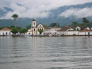
Paraty is a preserved Portuguese colonial (1500–1822) and Brazilian Imperial (1822–1889) municipality with a population of about 36,000. It is located on the Costa Verde, a lush, green corridor that runs along the coastline of the state of Rio de Janeiro, in Brazil. Paraty has become a tourist destination, known for the historic town and the coast and mountains in the region.

Botafogo is a beachfront neighborhood (bairro) in Rio de Janeiro, Brazil. It is a mostly upper middle class and small commerce community, and is located between the hills of Mundo Novo, Dona Marta and São João. The word Botafogo also refers to a Latin American ballroom dance move, named so because the area of Botafogo is where it originated.

Duque de Caxias is a city on Guanabara Bay and part of Rio de Janeiro metropolitan area, being the third most populous in Rio de Janeiro state, southeastern Brazil.

Nova Iguaçu is a municipality in Rio de Janeiro state in Brazil.

São Cristóvão is a Brazilian municipality in the Northeastern state of Sergipe. Founded at the mouth of the Vaza-Barris River on January 1, 1590, the municipality is the fourth oldest settlement in Brazil. São Cristóvão is noted for its historic city square, São Francisco Square, and numerous early colonial-period buildings. The 3 hectares site was designated a UNESCO World Heritage Site in 2010.

Rodrigo de Freitas Lagoon is a lagoon in the district of Lagoa in the Zona Sul area of Rio de Janeiro. The lagoon is connected to the Atlantic Ocean, allowing sea water to enter by a canal along the edge of a park locally known as Jardim de Alah.
São Cristóvão is a traditional neighborhood in north of Rio de Janeiro, Brazil.

The Rodovia Presidente Dutra,, colloquially known as Via Dutra is a federal highway which runs through the eastern part of the state of São Paulo and southwestern region of the state of Rio de Janeiro. It is the part of BR-116 connecting the city of São Paulo to the city of Rio de Janeiro.

The Old Cathedral of Rio de Janeiro dedicated to Our Lady of Mount Carmel, is an old Carmelite church which served as cathedral (Sé) of Rio de Janeiro from around 1808 until 1976. During the 19th century, it was also used successively as Royal and Imperial Chapel by the Portuguese Royal Family and the Brazilian Imperial Family, respectively. It is located in the Praça XV square, in downtown Rio. It is one of the most important historical buildings in the city.

Lapa is a neighborhood in the city of Rio de Janeiro, in Brazil. It is located in the centre of Rio and is famous for its historical monuments and nightlife.
Oswaldo Cruz is a neighborhood of the North Zone of Rio de Janeiro, of middle-class and lower middle-class situated near the neighborhoods of Madureira (east), Bento Ribeiro (west), Vila Valqueire (south), and Turiaçu (north). It is known nationally for being the birthplace of Portela, the great champion of the Carioca Carnival.

Santa Cruz is an extensive and populous neighborhood of the high class, lower middle and low in the West Zone of the municipality of Rio de Janeiro, Brazil, the farthest from the center of Rio de Janeiro. Cut by the Santa Cruz extension of the urban passenger rail network of the metropolitan region of Rio de Janeiro, it has a very diverse landscape, with commercial areas, residential and industrial.

Viseu is a Brazilian municipality in the state of Pará. It is located at a latitude 01º11'48 "south and a longitude 46º08'24" west, being at an altitude of 15 meters. Its estimated population in 2017 was 59,735 inhabitants according to IBGE. It has an area of 4,915,073 km² and, thus, the population density of 12.09 hab./km². Most people are Catholic, according to the Brazilian Institute of Geography and Statistics (IBGE). The municipal HDI is 0.515. The lands visuenses were discovered around June 24, 1531 by the navigator Diogo Leite.
Vista Alegre is a neighborhood in the North Zone of Rio de Janeiro, Brazil.
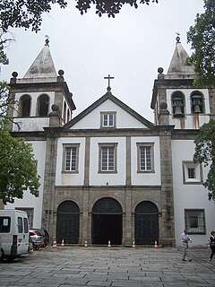
The Abbey of Our Lady of Montserrat, more commonly known as the Mosteiro de São Bento (Monastery of St. Benedict), is a Benedictine abbey located on the Morro de São Bento in downtown Rio de Janeiro, Brazil. The Mannerist style church is a primary example of Portuguese colonial architecture in Rio and the country.

The Metropolitan Cathedral of Our Lady Mother of God also called Catedral Metropolitana de Porto Alegre is a cathedral of the Catholic Church which is located in the city center, in the Praça da Matriz in Porto Alegre a town in the State of Rio Grande do Sul in Brazil.


