A biodiversity hotspot is a biogeographic region with significant levels of biodiversity that is threatened by human habitation. Norman Myers wrote about the concept in two articles in The Environmentalist in 1988 and 1990, after which the concept was revised following thorough analysis by Myers and others into “Hotspots: Earth’s Biologically Richest and Most Endangered Terrestrial Ecoregions” and a paper published in the journal Nature, both in 2000.

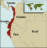
Tumbes-Chocó-Magdalena is a biodiversity hotspot, which includes the tropical moist forests and tropical dry forests of the Pacific coast of South America and the Galapagos Islands. The region extends from easternmost Panama to the lower Magdalena Valley of Colombia, and along the Pacific coast of Colombia and Ecuador to the northwestern corner of Peru. Formerly called the Chocó-Darién-Western Ecuador Hotspot, it has been expanded to include several new areas, notably the Magdalena Valley in northern Colombia. It is bounded on the east by the Andes Mountains. The Tumbes-Choco-Magdalena Hotspot is 1,500 km long and encircles 274,597 km². Tumbes-Choco-Magdalena is near the Pacific Ocean. The factors that threaten Tumbes-Choco-Magdalena are farming encroachment, deforestation, illegal crops, and population growth. Whereas the Panamanian and Colombian portion of the hotspot are relatively intact, approximately 98% of native forest in coastal Ecuador has been cleared, rendering it the most threatened tropical forest in the world. The hotspot includes a wide variety of habitats, ranging from mangroves, beaches, rocky shorelines, and coastal wilderness to some of the world's wettest rain forests in the Colombian Chocó. The hotspot includes a number of ecoregions:

In biogeography, the Mediterranean Basin, also known as the Mediterranean Region or sometimes Mediterranea, is the region of lands around the Mediterranean Sea that have mostly a Mediterranean climate, with mild to cool, rainy winters and warm to hot, dry summers, which supports characteristic Mediterranean forests, woodlands, and scrub vegetation. It was very important part of Mesopotamian civilizations.

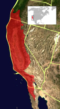
The California Floristic Province (CFP) is a floristic province with a Mediterranean-type climate located on the Pacific Coast of North America with a distinctive flora similar to other regions with a winter rainfall and summer drought climate like the Mediterranean Basin. This biodiversity hotspot is known for being the home of the Sierran giant sequoia tree and its close relative the coast redwood. In 1996, the Province was designated as a biodiversity hotspot allowing it to join ranks among 33 other areas in the world with many endemic species. To be named a biodiversity hotspot, an area has to contain species and plant life that cannot be found anywhere else in the world. The California Floristic Province is home to over 3,000 species of vascular plants, 60% of which are endemic to the province.

The Caucasus-Anatolian-Hyrcanian temperate forests is a composite ecoregion of southern Europe and West Asia, designated by the World Wildlife Fund as one of their Global 200 ecoregions, a list of priority ecoregions for conservation.

The Mountains of Central Asia are a biodiversity hot spot designated by Conservation International which covers several montane and alpine ecoregions of Central Asia, including those of the Pamir and Tian Shan ranges, and extending across portions of Afghanistan, China, Kazakhstan, Kyrgyzstan, Tajikistan, Uzbekistan and the Karakoram range in China, Pakistan and India. The Karakoram range is also famously known for Karakoram Anomaly that relates to the anomalous growth of glaciers in the central Karakoram that is in contrast with melting glaciers in other mountainous ranges of Himalayas and other parts of the world due to the effects of climate change.

Indo-Burma is a biodiversity hotspot designated by Conservation International.

The Southeastern Anatolia Region is a geographical region of Turkey. The most populous city in the region is Gaziantep. Other big cities are Şanlıurfa, Diyarbakır, Mardin and Adıyaman.

A forest steppe is a temperate-climate ecotone and habitat type composed of grassland interspersed with areas of woodland or forest.

Critical Ecosystem Partnership Fund (CEPF) is a joint biodiversity conservation initiative of l'Agence Française de Développement, Conservation International, European Union, Global Environment Facility, Government of Japan, and World Bank. CEPF also receives funding from several regional donors, including the MAVA Foundation, Margaret A. Cargill Philanthropies, and The Leona M. and Harry B. Helmsley Charitable Trust. The fund's headquarters are hosted at Conservation International in Arlington, Virginia, United States.

The Maputaland-Pondoland-Albany Hotspot (MPA) is a biodiversity hotspot, a biogeographic region with significant levels of biodiversity, in Southern Africa. It is situated near the south-eastern coast of Africa, occupying an area between the Great Escarpment and the Indian Ocean. The area is named after Maputaland, Pondoland and Albany. It stretches from the Albany Centre of Plant Endemism in the Eastern Cape Province of South Africa, through the Pondoland Centre of Plant Endemism and KwaZulu-Natal Province, the eastern side of Eswatini and into southern Mozambique and Mpumalanga. The Maputaland Centre of Plant Endemism is contained in northern KwaZulu-Natal and southern Mozambique.
The wildlife of Turkey is abundant and diverse. Turkey is a large country with many geographic and climatic regions and a great diversity of plants and animals, each suited to its own particular habitat. About 1,500 species of vertebrates and 19,000 species of invertebrates have been recorded in the country. Some of the world's staple crops were first cultivated in this area and many of their wild relatives are still found here. The country acts as a crossroads for many birds during migration, connecting Europe, Asia, and the Near East.

The Central Anatolian deciduous forests, also known as the Central Anatolian woodlands and steppe, is a Palearctic ecoregion of the Temperate broadleaf and mixed forest biome. It is located in Central Anatolia, Asian Turkey.

The Eastern Anatolian deciduous forests ecoregion is located in the mountains of eastern Turkey. It is a Palearctic ecoregion in the temperate broadleaf and mixed forests biome.

The Central Anatolian steppe is a Palearctic ecoregion in the temperate grasslands, savannas, and shrublands biome. It covers an area of 24,934 km2.

The Anatolian conifer and deciduous mixed forests is an ecoregion located in southwestern Anatolia, Turkey. It has a Mediterranean climate, and is part of the Mediterranean forests, woodlands, and scrub biome.

The Kopet Dag semi-desert ecoregion is a small ecoregion that crosses the border of southwestern Turkmenistan into northeastern Iran. It covers a transition zone between the deserts to the north and west, and the foothill steppes and woodlands in the higher Kopet Dag mountains to the east and the Alborz Mountains to the south. The terrain is mostly barren semi-desert and widespread 'takir', a type of seasonal salt flat or dried clay deposit in an interdune depression.

The Kopet Dag woodlands and forest steppe ecoregion coincides with the Kopet Dag mountains, straddling the southern border of Turkmenistan and the northeastern border of Iran. The region is one of high biodiversity, as it includes a full range of altitude zones, and variety of habitats included juniper-wooded slopes, montane grasslands, and tugay.


