This article talks about transportation in the Bahamas, a North American archipelagic state in the Atlantic Ocean.
The Berry Islands are a chain of islands and a district of the Bahamas, covering about thirty square miles (78 km2) of the northwestern part of the Out Islands.

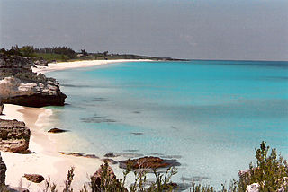
A cay, also spelled caye or key, is a small, low-elevation, sandy island on the surface of a coral reef. Cays occur in tropical environments throughout the Pacific, Atlantic, and Indian oceans, including in the Caribbean and on the Great Barrier Reef and Belize Barrier Reef.

Local government in The Bahamas exists at two levels: 32 districts and 41 towns. The boundaries of districts are defined by the First Schedule of The Bahamas Local Government Act 1996, defined with reference to parliamentary constituency boundaries. The Second Schedule lists 13 districts which are divided into town areas. Towns are governed by directly elected town committees. Second Schedule districts are governed by nine-person district councils composed of the chairs of the town committees, and if numerically required, additional people elected by the town committees. The 19 Third Schedule districts are unitary authorities which cannot be divided into towns. They are governed by nine-person district councils which are directly elected by voters. The powers of Second Schedule and Third Schedule councils are slightly different, and the Third Schedule district known as the City of Freeport has a slightly different list of enumerated powers.

The Abaco Islands lie in the northern Bahamas, about 193 miles east of Miami, Florida. The main islands are Great Abaco and Little Abaco, which is just west of Great Abaco's northern tip. There are several smaller barrier cays, of which the northernmost are Walker's Cay and its sister island Grand Cay. To the south, the next inhabited islands are Spanish Cay and Green Turtle Cay, with its settlement of New Plymouth, Great Guana Cay, private Scotland Cay, Man-O-War Cay, and Elbow Cay, with its settlement of Hope Town. Southernmost are Tilloo Cay and Lubbers Quarters. Also of note off Abaco's western shore is Gorda Cay, now a Disney-owned island and cruise ship stop renamed Castaway Cay. Also in the vicinity is Moore's Island. On the Big Island of Abaco is Marsh Harbour, the Abacos' commercial hub and the Bahamas' third-largest city, plus the resort area of Treasure Cay. Both have airports. A few mainland settlements of significance are Coopers Town and Fox Town in the north and Cherokee and Sandy Point in the south. Administratively, the Abaco Islands constitute seven of the 31 Local Government Districts of the Bahamas: Grand Cay, North Abaco, Green Turtle Cay, Central Abaco, South Abaco, Moore's Island, and Hope Town.

Exuma is a district of The Bahamas, consisting of over 365 islands and cays.

Disney's Castaway Cay, or simply Castaway Cay, is a private island in the Bahamas which serves as an exclusive port for the Disney Cruise Line ships. It is located near Great Abaco Island and was formerly known as Gorda Cay. In 1997, The Walt Disney Company purchased a 99-year land lease for the cay from the Bahamian government, giving the company substantial control over the island.

Rum Cay is an island and district of the Bahamas. It measures 30 square miles (78 km2) in area, it is located at Lat.: N23 42' 30" - Long.: W 74 50' 00". It has many rolling hills that rise to about 120 feet.

Grand Cay is one of the districts of the Bahamas. It is geographically located in the Abaco Islands.

Green Turtle Cay is one of the barrier islands off mainland Great Abaco, The Bahamas. It can only be reached via ferry from the mainland or boat. There is not an airport on the island. It is considered part of the "Abaco Out Islands" and is 3 miles (4.8 km) long and ½ mile wide. It was named after the once abundant green turtles that inhabited the area. In 1977, Key West, Florida became a sister city to New Plymouth, Green Turtle Cay's village.
The Hope Town District Council is a local government council in the Bahamas. It is a third schedule district council located within the Abaco Islands of the northwest Bahamas.
The Cat Cays are two islands in the Bahamas, North Cat Cay and South Cat Cay, approximately 10 miles (16 km) south of Bimini. North Cat Cay is a privately owned island and is run as a private members club by the Cat Cay Yacht Club. South Cat Cay is currently under development.

The following outline is provided as an overview of and topical guide to The Bahamas:
The Bahamas National Trust is a non-profit organisation in the Bahamas that manages the country's 32 national parks. Its headquarters is located in New Providence in the Bay Street Business Centre, East Bay Street. Its office was formally located at The Retreat Gardens on Village Road. The Bahamas National Trust was created by an Act of Parliament in 1959, through the efforts of two groups of conservationists.

The following is an alphabetical list of topics related to the Commonwealth of The Bahamas.

Pig Beach located on Big Major Cay is a beach on an uninhabited island located in Exuma, the Bahamas. The island takes its unofficial name from the fact that it is populated by a colony of feral pigs which live on the island. It has become a tourist attraction in modern times.

Long Island is an island in The Bahamas that is split by the Tropic of Cancer. It is one of the Districts of the Bahamas and is known as the most scenic island in the Bahamas. Its capital is Clarence Town. The population of Long Island is 3,094 inhabitants.

Renegades Football Club is a Bahamian football club based in Lyford Cay while playing its home game in the capital Nassau. The team plays in the BFA Senior League. The team is also known by its nickname of the Ospreys, to distinguish it from a second Lyford Cay FC that has simultaneously played in the BFA Senior League nicknamed the "Warriors". The Warriors serve as the reserve team for the Ospreys.
Lookout Cay at Lighthouse Point, or simply Lookout Cay, is a private peninsula in The Bahamas which serves as an exclusive port for the Disney Cruise Line ships. It is located in the south-eastern region of Bannerman Town, South Eleuthera. In March 2019, The Walt Disney Company purchased the peninsula from the Bahamian government, giving the company control over the area.
