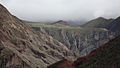
Iruya

Last updated
Iruya
Classical view of Iruya, Argentina.jpg
View of Iruya
Argentina Salta location map.svg
Red pog.svg
Location of Iruya in Argentina.
Argentina location map.svg
Red pog.svg
Iruya (Argentina)
Coordinates: 22°47′30″S65°12′59″W / 22.791585°S 65.216361°W / -22.791585; -65.216361
Founded1753
Elevation
2,780 m (9,120 ft)
Population
 (2010)
  Total1,523
  Density1.66/km2 (4.3/sq mi)

Iruya is a small town of population 1,070 in northwestern Argentina. It is located in the Salta Province of northwestern Argentina, and is the capital of the Iruya Department.

Contents

Overview

Located in the altiplano region along the Iruya River, Iruya sits nestled against the mountainside at an elevation of 2,780 meters (9,120 feet). It is located over 300 kilometers (190 mi) from the province capital of Salta. There is no direct road connection to the rest of the Salta province and access is through a road to the adjacent Jujuy province, a 50 km (31 mi) portion of which is unpaved. [1] Nonetheless, the town is popular with tourists for its scenic location and townscape and friendly locals. [2] 8 km north of Iruya there is the village of San Isidro, 7 km north there is the village of San Juan, 6 km south there is the village of Pueblo Viejo.

Iruya's name is derived from the Quechua language, meaning "abundance of straw". [3]

History

Iruya was officially founded in 1753, but the first inhabitants settled here around 100 years earlier. They were mainly aboriginals of which the oldest roots go back to the Ocloyas, a people belonging to the ethnic group of the Kolla who stem from the Kollasuyo, which used to be one of the four regions of the Inca empire. [4]

Iruya's church was built in 1690. [5]

Climate

Climate data for Colanzulí, Iruya (1993–2013)
MonthJanFebMarAprMayJunJulAugSepOctNovDecYear
Record high °C (°F)26.0
(78.8)
27.0
(80.6)
26.0
(78.8)
25.7
(78.3)
23.0
(73.4)
22.0
(71.6)
22.3
(72.1)
25.0
(77.0)
25.0
(77.0)
26.0
(78.8)
26.0
(78.8)
25.6
(78.1)
27.0
(80.6)
Average high °C (°F)15.6
(60.1)
15.5
(59.9)
16.0
(60.8)
17.3
(63.1)
16.4
(61.5)
15.7
(60.3)
15.3
(59.5)
16.6
(61.9)
17.3
(63.1)
17.5
(63.5)
17.0
(62.6)
16.8
(62.2)
16.4
(61.5)
Daily mean °C (°F)10.2
(50.4)
9.7
(49.5)
9.8
(49.6)
9.7
(49.5)
8.2
(46.8)
7.6
(45.7)
7.2
(45.0)
8.1
(46.6)
8.8
(47.8)
9.5
(49.1)
10.0
(50.0)
10.6
(51.1)
9.1
(48.4)
Average low °C (°F)5.2
(41.4)
4.8
(40.6)
4.5
(40.1)
3.2
(37.8)
1.3
(34.3)
0.6
(33.1)
0.1
(32.2)
0.8
(33.4)
1.6
(34.9)
2.9
(37.2)
3.9
(39.0)
4.8
(40.6)
2.8
(37.0)
Record low °C (°F)1.0
(33.8)
−1.0
(30.2)
−1.0
(30.2)
−3.6
(25.5)
−6.0
(21.2)
−11.0
(12.2)
−11.0
(12.2)
−9.8
(14.4)
−10.0
(14.0)
−6.0
(21.2)
−4.0
(24.8)
−1.0
(30.2)
−11.0
(12.2)
Average precipitation mm (inches)70.2
(2.76)
60.1
(2.37)
39.5
(1.56)
9.5
(0.37)
0.1
(0.00)
0.0
(0.0)
0.0
(0.0)
1.2
(0.05)
1.7
(0.07)
7.5
(0.30)
12.8
(0.50)
35.3
(1.39)
237.9
(9.37)
Source: Red Hidrológica Nacional [6]

See also

Related Research Articles

San Juan[saŋ ˈxwan], Spanish for Saint John, may refer to:

Salta Province Province of Argentina

Salta is a province of Argentina, located in the northwest of the country. Neighboring provinces are from the east clockwise Formosa, Chaco, Santiago del Estero, Tucumán and Catamarca. It also surrounds Jujuy. To the north it borders Bolivia and Paraguay and to the west lies Chile.

San Salvador de Jujuy City in Jujuy, Argentina

San Salvador de Jujuy, Jujuy, Argentina, commonly known as Jujuy and locally often referred to as San Salvador, is the capital and largest city of Jujuy Province in northwest Argentina. Also, it is the seat of the Doctor Manuel Belgrano Department. It lies near the southern end of the Humahuaca Canyon where wooded hills meet the lowlands.

La Quiaca City in Jujuy, Argentina

La Quiaca is a small city in the north of the province of Jujuy, Argentina, on the southern bank of the La Quiaca River, opposite the town of Villazón, Bolivia. It lies at the end of National Route 9, 289 km (180 mi) from San Salvador de Jujuy, and at an altitude of 3,442 m (11,293 ft) above mean sea level.

National Route 40 (Argentina) Highway in Argentina

National Route 40, also known as RN40 or "Ruta 40", is a route in western Argentina, stretching from Punta Loyola near Rio Gallegos in Santa Cruz Province in the south to La Quiaca in Jujuy Province in the north. The route parallels the Andes mountains. The southern part of the route, by now largely paved, has become a well-known adventure tourism journey, and there are plans to pave the whole road.

National Route 9 (Argentina) Highway in Argentina

National Route 9 is a major road in Argentina, which runs from the center-east to the northwest of the country, crossing the provinces of Buenos Aires, Santa Fe, Córdoba, Santiago del Estero, Tucumán, Salta and Jujuy. It starts on Avenida General Paz, which marks the border between the Autonomous City of Buenos Aires and the surrounding province of the same name, and ends at the Horacio Guzmán International Bridge, on the La Quiaca River, traversing 1,967 km (1,222 mi). The road is a limited access motorway from Buenos Aires to Rosario.

San Antonio de los Cobres Place in Salta, Argentina

San Antonio de los Cobres is a small town of population 5,482 in northwestern Argentina. It is the capital of the Los Andes Department of the Salta Province.

Pueblo Viejo Canton Canton in Los Ríos Province, Ecuador

Pueblo Viejo Canton is a canton of Ecuador, located in the Los Ríos Province. Its capital is the town of Pueblo Viejo. Its population at the 2001 census was 29,420.

Amaicha del Valle Place in Tucumán Province, Argentina

Amaicha del Valle is a settlement in Tucumán Province in northern Argentina. It is located in the Tafi del Valle department, in the northwestern province of Tucuman, Argentina, 164 km from the provincial capital, San Miguel de Tucumán and 57 km from the departmental capital, Tafi del Valle.

Purmamarca Locality in Jujuy Province, Argentina

Purmamarca is a town in the Tumbaya Department of the Jujuy Province in Argentina.

Isla de Cañas is a village and rural municipality in Salta Province in northwestern Argentina. It is located at 610 meters above sea level, on the eastern slopes of the Sierra de Santa Victoria, 307 km from the capital of Salta. The municipality of Isla de Cañas is only accessible from Oran, there are no bus services, only private shuttles that travel from Oran to Isla de Cañas three times a week; these shuttles are only available before 5pm on Mondays, Wednesdays and Fridays.

Pueblo Viejo, Salta Village in Salta Province, Argentina

Pueblo Viejo is a small village in the Iruya Department in Salta Province in northwestern Argentina. It is located near the village Iruya and is connected through dirt road Ruta Provincial 165-S with Campo Carreras, which is a locality of the village Rodeo Colanzulí.

San Carlos is a head village of the department of San Carlos, Province of Salta, Argentina. San Carlos is a historic village in Calchaquíes Valleys located at the National Route 40, 27 km from Cafayate.

San Isidro de Iruya Municipality and village in Salta Province, Argentina

San Isidro de Iruya is a village and rural municipality in Salta Province in northwestern Argentina.

La Mesada is a village in northwestern Argentina. It is part of the Iruya Department in Salta Province, located northeast of the village of Iruya at 3,000 m altitude on the Cordillera Oriental on the Nazareno River. La Mesada consists of the two districts of La Mesada Grande and La Mesada Chica.

San Juan is a small village in northwestern Argentina. It is part of the Iruya Department in the Salta Province, located 7 km north of the Iruya village, 4 km northeast of the village of San Isidro and 4 km west of the village of Chiyayoc.

Chiyayoc is a small village in northwestern Argentina. It is part of the Iruya Department in the Salta Province. The village is located at an elevation of 3100 meters, 4 km east of the village of Salta and 9 km north of the village of Iruya.

Iruya Department Department in Salta, Argentina

Iruya is a department is located in the north of Salta Province in northwest Argentina in the high altitude basin of the Bermejo River. It is one of 23 administrative units in the province.

Chicoana Department Department in Salta, Argentina

Chicoana is a department located in Salta Province, in northwestern Argentina.

Metán Department Department in Salta, Argentina

Metán is a department located in Salta Province, in Argentina.

References

  1. "Salta: Iruya". Enjoy Travel Argentina. Enjoy Corporation SA. 2009. Retrieved February 10, 2009.
  2. Ingledew, Roberto. "Off the Beaten Track to Iruya". Gosouthamerica.about.com. About.com . Retrieved February 10, 2009.
  3. http://www.iruyaonline.com/
  4. http://www.iruyaonline.com/iruya-historia.html
  5. https://www.facebook.com/Flicts/ [ user-generated source ]
  6. "Base de Datos Hidrológica Integrada" (in Spanish). Secretaría de Infraestructura y Política Hídrica. 7 November 2017. Retrieved March 13, 2018.

Coordinates: 22°47′30″S65°12′59″W / 22.791585°S 65.216361°W / -22.791585; -65.216361