Mercer County is a county located in the northwestern portion of the U.S. state of Missouri. As of the 2020 census, the population was 3,538, making it the second-least populous county in Missouri. Its county seat is Princeton. The county was organized February 14, 1845, and named for General John F. Mercer of the Revolutionary War.

Cap-Vert, or the Cape Verde Peninsula, and Kap Weert or Bopp bu Nëtëx, is a peninsula in Senegal and the westernmost point of the continent of Africa and of the Afro-Eurasia mainland. Portuguese explorers called it Cabo Verde or "Green Cape". The Cape Verde islands, 570 kilometres (350 mi) further west, are named after the cape. Dakar, the capital of Senegal, occupies parts including its southern tip. The peninsula marks the border between Grande Côte to the north and Petite Côte to the south. It is delimited by two capes, Pointe des Almadies to the northwest and cap Manuel to the southeast.

Orrville is a town in Dallas County, Alabama, United States. At the 2020 census, the population was 150. According to the 1910 U.S. census, Orrville incorporated in 1908, though it was listed as an incorporated community prior to that.

Chuichu is a census-designated place (CDP) in Pinal County, Arizona, United States. The population was 308 at the 2020 census. It is the northernmost traditional village on the Tohono O'odham Nation reservation.

Carlisle is a city in Lonoke County, Arkansas, United States. It is the easternmost municipality within the Little Rock–North Little Rock–Conway Metropolitan Statistical Area. Carlisle was incorporated in 1878. As of the 2010 census it had a population of 2,214.

Spring Valley is a census-designated place (CDP) in the East County region of San Diego County, California. The population was 28,205 at the time of the 2010 census.

Oakwood Hills is a village in McHenry County, Illinois, United States. It was founded in 1959. The population was 2,076 at the 2020 census.

McCausland is a city in Butler Township, Scott County, Iowa, United States. The population was 313 at the time of the 2020 census.
Charlotte is a town in Washington County, Maine, United States. The town was named for the wife of legislator William Vance. The population was 337 at the 2020 census.

Early is a city located in Brown County in west-central Texas, United States. It is a suburb of Brownwood, and the population was 3,087 at the 2020 census. It is named for Walter U. Early, who donated land for the local schools. It is home to the Early Independent School District and the Heartland Mall.

Marmet is a town in Kanawha County, West Virginia, United States, along the Kanawha River. The population was 1,501 at the 2020 census.
East Jakarta, abbreviated as Jaktim, is the largest of the five administrative cities which form the Special Capital Region of Jakarta, Indonesia, with a land area of 188.03 km2. It had a population of 2,693,896 at the 2010 Census and 3,037,139 at the 2020 Census; the official estimate as at mid 2023 was 3,315,114, making it the most populous of the five administrative cities within Jakarta. East Jakarta is not self-governed and does not have a city council, hence it is not classified as a proper municipality.

Chorfa is a town and commune in Mascara Province, Algeria. The population in 2002 was 14,850.

Roberto Payán is a town and municipality in the Nariño Department, Colombia. The municipal seat is known as San José de las Lagunas.
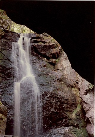
Royalston Falls is a 50 foot (15 m) waterfall and granite gorge located in Royalston, Massachusetts along Falls Brook, a tributary of the Tully River which in turn is a tributary of the Millers River. The falls are part of a 217-acre (88 ha) open space preserve acquired in 1951 by the land conservation non-profit organization The Trustees of Reservations. The 22-mile (35 km) Tully Trail and the 235-mile (378 km) New England National Scenic Trail pass through the property.

Bluie was the United States military code name for Greenland during World War II. It is remembered by the numbered sequence of base locations identified by the 1941 United States Coast Guard South Greenland Survey Expedition, and subsequently used in radio communications by airmen unfamiliar with pronunciation of the Greenlandic Inuit and Danish names of those locations. These were typically spoken BLUIE (direction) (number), with direction being east or west along the Greenland coast from Cape Farewell.

The Tataskweyak Cree Nation is a First Nations band government whose primary community is located at Split Lake, Manitoba, on the Nelson River system. Despite its remote location, it is serviced by Provincial Road 280, which connects the community to Thompson.
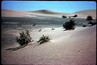
The Rice Valley Wilderness is a wilderness area near Blythe and Rice in the Mojave Desert region of California, managed by the Bureau of Land Management.
Belfort is an unincorporated community in Stark County, in the U.S. state of Ohio.
Grace is an unincorporated community in northern Laclede County, in the Ozarks of south central Missouri. The community is located on Missouri Route D, two miles north of Eldridge and two miles west of Missouri Route 5.