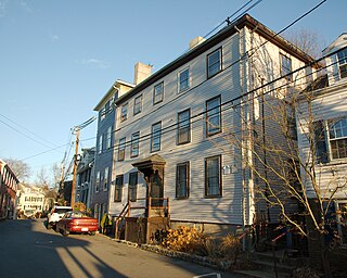
Early New England home built around 1680 by Isaac Morrill.
Isaac was the son of the first settler Abraham Morrill. Abraham arrived in Massachusetts Bay Colony September 16, 1632 on the ship the Lyon. Captain William Pierce was the Captain of the Lyon ship. Isaac followed in his father's footsteps as a blacksmith making weapons for the army and doing great metal work for different properties and buildings. Isaac was born July 10, 1646. In the year 1670 on November 14, Issac married Phoebe Gill.
The Isaac Morrill House is located across the street from the training field. In 1789, the first President of the United States, George Washington, reviewed the troops in the training field directly across the street from the Isaac Morrill House. The training field is where the militia trained for the French and Indian Wars, also for the revolution War of 1812. Portsmouth Road was the main road between all of the towns North along the sea and of Massachusetts. Isaac and his father Abraham were members of the Ancient and Honorable Artillery Company of Massachusetts.
Acton is a town in Middlesex County, Massachusetts, United States, approximately 21 miles (34 km) west-northwest of Boston along Massachusetts Route 2 west of Concord and about ten miles (16 km) southwest of Lowell. The population was 24,021 in April 2020, according to the United States Census Bureau. It is bordered by Westford and Littleton to the north, Concord and Carlisle to the east, Stow, Maynard, and Sudbury to the south and Boxborough to the west. Acton became an incorporated town in 1735. The town employs the Open Town Meeting form of government with a town manager and an elected, five-member select board. Acton was named the 11th Best Place To Live among small towns in the country by Money Magazine in 2015, and the 16th best in 2009 and in 2011. The local high school, Acton-Boxborough Regional High School, was named a Blue Ribbon School by the U.S. Department of Education in 2009.
Medford is a city 6.7 miles (10.8 km) northwest of downtown Boston on the Mystic River in Middlesex County, Massachusetts, United States. At the time of the 2020 U.S. Census, Medford's population was 59,659. It is home to Tufts University, which has its campus both sides of the Medford and Somerville border.
Cape Ann is a rocky peninsula in northeastern Massachusetts on the Atlantic Ocean. It is about 30 miles (48 km) northeast of Boston and marks the northern limit of Massachusetts Bay. Cape Ann includes the city of Gloucester and the towns of Essex, Manchester-by-the-Sea and Rockport.
Northern Essex Community College (NECC) is a public community college in Essex County, Massachusetts. The college serves residents of the Merrimack Valley and Southern New Hampshire. It has campuses in Haverhill and Lawrence. The college is part of the Massachusetts Higher Education system. More than 6,600 students are enrolled in 70 credit associate degree and certificate programs and another 3,400 take noncredit workforce development and community education classes on campus, and at businesses and community sites across the Merrimack Valley. The school's athletic teams are known as the Knights. Northern Essex Community College is accredited by the New England Commission of Higher Education.
South Medford is the southern neighborhood of Medford, Massachusetts.
The North River is a river, approximately 12 miles (19 km) long, in eastern Massachusetts, the United States. It is primarily a tidal river, formed by the confluence of the Indian Head River and Herring Brook. The North River forms the boundary between the towns of Norwell, Pembroke, Massachusetts, Hanover, Massachusetts and downstream, the boundary between Scituate and Marshfield. The river flows into Massachusetts Bay at New Inlet, where it also converges with the mouth of the South River. The North River area is also known as the "Irish Riviera" due to the large Irish American population that migrated during the 19th century.
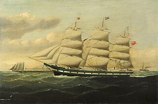
HMSEurydice was a 26-gun Royal Navy corvette which was the victim of one of Britain's worst peacetime naval disasters when she sank in 1878.
First Presbyterian Church, also known as Old South, is a Presbyterian congregation in Newburyport, Massachusetts that is part of the Presbyterian Church (USA). The church building is located at 29 Federal Street in Newburyport. The current pastor is the Reverend Laurel Cockrill.
USS Grouse (AMS-15/YMS-321) was a YMS-1-class minesweeper of the YMS-135 subclass built for the United States Navy during World War II.
Monohansett was a sidewheel steamer operating as a ferry serving the island of Martha's Vineyard during the late nineteenth century. She was named after Monohansett Island, a tiny 12-acre (4.9-hectare) island off Naushon Island.
Ten Hills is a neighborhood in the northeastern part of the city of Somerville, Massachusetts. The area is roughly wedge-shaped, about 50 acres (200,000 m2) in size, and is bounded by the Mystic River to the north, McGrath Highway to the east, and is largely separated from the rest of Somerville by Interstate 93 to the southwest. Ten Hills is next to Assembly Square in the east, and Winter Hill in the southwest. The neighborhood landscape is predominated by a single hill, the peak of which is roughly at the intersection of Temple and Putnam Roads. The Ten Hills neighborhood is located in Ward 4, Precinct 1 of the City of Somerville, which is in the 34th district of Middlesex County.
Badger's Island is located in the Piscataqua River at Kittery, Maine, United States, directly opposite Portsmouth, New Hampshire. It carries U.S. Route 1 between the states, connecting to the Kittery mainland by the Badger's Island Bridge, and to New Hampshire by the Memorial Bridge. Now largely a suburb of Portsmouth, the island features houses, condominiums, restaurants and marinas.
The Boston Marine Society is a charitable organization in Boston, Massachusetts, formed "to 'make navigation more safe' and to relieve members and their families in poverty or other 'adverse accidents in life.'" Membership generally consists of current and former ship captains. The society provides financial support to members and their families in times of need; and also actively advises on maritime navigational safety such as the placement of lighthouses and buoys, and selection of Boston Harbor pilots.
Harmony Grove Cemetery is a rural cemetery in Salem, Massachusetts. It was established in 1840 and is located at 30 Grove Street. The cemetery is approximately 35 acres in size and was designed by Francis Peabody and Alexander Wadsworth.
The Marblehead Summer House is a house in Marblehead, Massachusetts, in the United States. There is evidence of it having been constructed as a one-storey building in 1717, and it was later converted to become an early three-storey building.
Thomas Wellman was born in about 1615 in England and died at Lynn, Massachusetts on 10 October 1672. He was among the early settlers of the Massachusetts Bay Colony and progenitor of the Wellman family of New England. At age 21 he traveled from London to Barbados in 1634 or 1635 aboard Hopewell as part of a mass exodus of Puritans called the Great Migration.
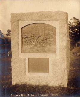
The Raid on Wells occurred during King William's War when French and Wabanaki Confederacy forces from New France attacked the English settlement at Wells, Maine, a frontier town on the coast below Acadia. The principal attack (1692) was led by La Brognerie, who was killed. Commander of the garrison, Captain James Converse, successfully repelled the raid despite being greatly outnumbered.
Camp Edwin M. Stanton was an American Civil War training camp that existed from 1861 to 1862 in Lynnfield, Massachusetts. When the camp first opened in 1861 it was known as Camp Schouler, named for Massachusetts Adjutant General William Schouler. In some references it is misspelled as Camp Schuyler. After President Abraham Lincoln's call for 300,000 troops in July 1862, the camp was revived and renamed in honor of United States Secretary of War Edwin M. Stanton. It served as the training camp and rendezvous for recruits from eastern Massachusetts. The camp trained ten infantry regiments and four artillery batteries of the Massachusetts militia, including the 17th, 19th, 22nd, 23rd, 33rd, 35th, 38th, 39th, 40th, and 41st regiments of infantry and the 3rd, 5th, 9th, and 10th batteries of light artillery. Soldiers stationed at Camp Schouler/Stanton during training included Edward A. Wild, Henry Wilson, Nelson A. Miles, Edward Winslow Hinks, and Arthur F. Devereux. During World War I it was renamed Camp Houston and served as a Massachusetts National Guard mobilization camp in 1917. It was located on the Newburyport Turnpike near the Peabody, Massachusetts line. The camp was divided into streets, with tents and cook houses located on both sides of the Turnpike to Suntaug Lake.
This page is based on this Wikipedia article Text is available under the CC BY-SA 4.0 license; additional terms may apply. Images, videos and audio are available under their respective licenses.