Anguilla is a British overseas territory in the Caribbean. It is one of the most northerly of the Leeward Islands in the Lesser Antilles, lying east of Puerto Rico and the Virgin Islands and directly north of Saint Martin. The territory consists of the main island of Anguilla, approximately 16 miles long by 3 miles (5 km) wide at its widest point, together with a number of much smaller islands and cays with no permanent population. The territory's capital is The Valley. The total land area of the territory is 35 square miles (91 km2), with a population of approximately 14,731 (2018).

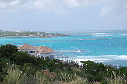
Anguilla is an island in the Leeward Islands, which lies between the Caribbean Sea in the west and the open Atlantic Ocean in the east. It is a long, flat, dry/wet, scrub-covered coral island, south and east of Puerto Rico and north of the Windward chain. It is separated from the British Virgin Islands by the Anegada Passage. The island has no significant elevations with its terrain consisting entirely of beaches, dunes, and low limestone bluffs.
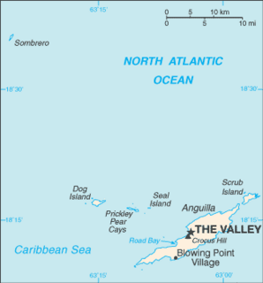
The Valley is the capital of Anguilla, one of its fourteen districts, and the main town on the island. As of 2011, it had a population of 1,067.
Area code 264 is the telephone area code of Anguilla in the North American Numbering Plan (NANP). The area code was created in a split of the original numbering plan area with area code 809. Permissive dialing started 31 March 1997 and ended on 30 September 1997. The area code is also represented on the telephone dial by the letter sequence ANG.
Education in Anguilla is compulsory between the ages of 5 and 17. In 1998, the gross primary enrollment rate was 100.7 percent, and the net primary enrollment rate was 98.9 percent. The government has collaborated with UNESCO to develop an Education for All plan that aims to raise educational achievement levels, improve access to quality special education services and provide human resource training for teachers and education managers.

Blowing Point is a village and one of the fourteen Districts of Anguilla, located on the southern coast. It is home to Anguilla's ferry terminal.

East End is one of the fourteen Districts of Anguilla. Its population at the 2011 census was 671.
George Hill is one of the fourteen Districts of Anguilla. Its population at the 2011 census was 879.
North Hill is one of the fourteen Districts of Anguilla. Its population at the 2011 census was 464.
North Side is one of the fourteen Districts of Anguilla. Its population at the 2011 census was 1,980.
Sandy Hill is one of the fourteen Districts of Anguilla. Its population at the 2011 census was 636.
South Hill is one of the fourteen Districts of Anguilla. Its population at the 2011 census was 1,722.
Stoney Ground is one of the fourteen Districts of Anguilla. Its population at the 2011 census was 1,549.
West End is one of the fourteen Districts of Anguilla. Its population at the 2011 census was 813.
The Quarter is one of the fourteen Districts of Anguilla. Its population at the 2011 census was 959.
The Farrington is one of the fourteen Districts of Anguilla. Its population at the 2011 census was 624.

The Republic of Anguilla was a short-lived, unrecognised independent state on the island of Anguilla. It lasted from 11 July 1967 until 19 March 1969, when British control was re-established.
Government House is the official residence of the Governor of Anguilla, located in Old Ta in Anguilla.
Cyrus Williams Sylvan-Vanterpool, is an Anguillan professional footballer who plays for the Anguilla national football team.