The geography of France consists of a terrain that is mostly flat plains or gently rolling hills in the north and west and mountainous in the south and the east.

The Arctic Archipelago, also known as the Canadian Arctic Archipelago, is a group of islands north of the Canadian mainland.

The Tawa River is a tributary of the Narmada River of Central India.

Pedro Bank is a large bank of sand and coral, partially covered with seagrass, about 80 km south and southwest of Jamaica, rising steeply from a seabed of 800 metres depth. It slopes gently from Pedro Cays to the west and north with depths from 13 to 30 metres. The total area of the bank within the 100-metre (328-foot) isobath measures 8,040 square kilometres. The area of a depth to 40 metres is triangular, 70 kilometres long east-west, and 43 kilometres wide. 2,400 square kilometres are less than 20 metres deep. With its islets, cays and rocks, a total land area of 270,000 m2 (2,906,256 sq ft), it is the location of one of the two offshore island groups of Jamaica, the other one being the Morant Cays. The bank is centered at 17°06′N78°20′W.
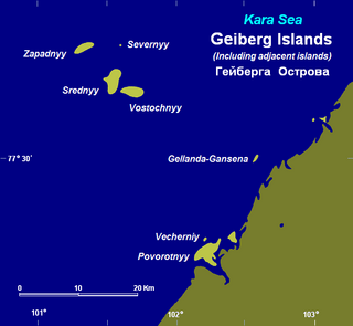
The Heiberg Islands, spelt Geyberg, Gejberg or Geiberg is a group of four small islands covered with tundra vegetation and with scattered stones on their shores. They lie in the Kara Sea, between the bleak coast of Siberia's Taymyr Peninsula and Severnaya Zemlya. These islands are between 35 and 45 km from the continental shore.
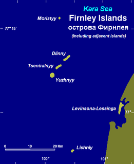
The Firnley Islands is a group of three small islands covered with tundra vegetation and with scattered stones on their shores. They lie in the Kara Sea, close to the bleak coast of Siberia's Taymyr Peninsula, not far east of the Nordenskjold Archipelago. These islands lie about 35 km from the continental shore.
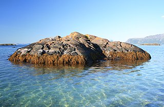
Bölscheøya is an island southwest of Negerpynten, the southeastern point of Edgeøya. It is part of Thousand Islands. The island was named in 1868 by the German geographer August Petermann (1822–78) after the German journalist Carl Bölsche, father of the German writer and zoologist Wilhelm Bölsche (1843–93). The remains of a whaling station from the 17th century can be found on the island.
Brækmoholmane is an island group composed of three islands, Store Brækmoholmen, Trønderen and Alkekongen. They form part of Thousand Islands, an archipelago south of Edgeøya. The islands are named after the Norwegian sailor and fisherman Sivert Brækmo (1853-1930), who visited Svalbard regularly between 1876 and 1895.
Trønderen is an islet in Brækmoholmane, part of Thousand Islands, an island group south of Edgeøya. The island is named after Trøndelag, Norway, the birthplace of Sivert Brækmo (1853–1930), a Norwegian sailor and fishermen who regularly visited Svalbard between 1876 and 1895.
Store Brækmoholmen is the largest island in Brækmoholmane, part of Thousand Islands, an island group south of Edgeøya. The island is named after Sivert Brækmo (1853-1930), a Norwegian sailor and fishermen who regularly visited Svalbard between 1876 and 1895.
Store Meinickeøya is the largest island in Meinickeøyane, part of Thousand Islands, an island group south of Edgeøya.
Teisten is an islet in Menkeøyane, part of Thousand Islands, a Norwegian island group south of Edgeøya.
Skråholmen is an islet about 2 miles (3 km) northeast of Schareholmane. It is part of Thousand Islands, an archipelago south of Edgeøya.
Blåmåken is the northeasternmost island in Menkeøyane, part of Thousand Islands, a Norwegian archipelago south of Edgeøya.
Alka is a Norwegian islet between Gassen and Havella in Menkeøyane, part of Thousand Islands, an archipelago south of Edgeøya.
Gassen is the westernmost of the large islets in Menkeøyane, part of Thousand Islands, a Norwegian archipelago south of Edgeøya.
The Findlay Group is a group of islands in the Canadian Arctic Archipelago in Qikiqtaaluk Region, Nunavut. This Arctic Ocean group consists of Lougheed Island, Stupart Island, Edmund Walker Island, Grosvenor Island and Patterson Island.

German submarine U-974 was a Type VIIC U-boat of Nazi Germany's Kriegsmarine during World War II.