
Israel Roll (1937 - June 2010) was an Israeli archaeologist and academic.
Israel Roll (1937 - June 2010) was an Israeli archaeologist and academic.
Israel Roll was the director of the Apollonia-Arsuf excavations and one of the directors of the Roman Temple dig at Kedesh. He completed his bachelor's degree at the Hebrew University in Jerusalem. His Ph.D. thesis on the cult of Mithras [1] is from the Sorbonne.
Roll was a leading authority on classical archaeology, specializing in the Roman road system in Judea and the adjacent provinces. The Roman Road Survey was directed and published by Roll, Benjamin Isaac and Moshe Fischer. The first publication describes the Legio - Scythopolis road. [2] The second publication, describing the Jaffa- Jerusalem roads, was published in 1996. [3]

Tel Aviv-Yafo, often referred to as just Tel Aviv, is the most populous city in the Gush Dan metropolitan area of Israel. Located on the Israeli Mediterranean coastline and with a population of 467,875, it is the economic and technological center of the country. If East Jerusalem is considered part of Israel, Tel Aviv is the country's second most populous city after Jerusalem; if not, Tel Aviv is the most populous city ahead of West Jerusalem.

Antipatris was a city built during the first century BC by Herod the Great, who named it in honour of his father, Antipater. The site, now a national park in central Israel, was inhabited from the Chalcolithic Period to the late Roman Period. The remains of Antipatris are known today as Tel Afek, although formerly as Kŭlat Râs el 'Ain. It has been identified as either the tower of Aphek mentioned by Josephus, or the biblical Aphek, best known from the story of the Battle of Aphek. During the Crusader Period the site was known as Surdi fontes, "Silent springs". The Ottoman fortress known as Binar Bashi or Ras al-Ayn was built there in the 16th century.

Herzliya is an affluent city in the central coast of Israel, at the northern part of the Tel Aviv District, known for its robust start-up and entrepreneurial culture. In 2021 it had a population of 103,318. Named after Theodor Herzl, the founder of modern Zionism, Herzliya covers an area of 21.6 square kilometres (8.3 sq mi). Its western, beachfront area is called Herzliya Pituah and is one of Israel's most affluent neighborhoods and home to numerous embassies, ambassadors' residences, companies headquarters, and houses of prominent Israeli business people.

Apollonia, known in the Early Islamic period as Arsuf and in the Crusader Kingdom of Jerusalem as Arsur, was an ancient city on the Mediterranean coast of today's Israel. In Israeli archaeology it is known as Tel Arshaf. Founded by the Phoenicians during the Persian period in the late sixth century BCE, it was inhabited continuously until the Crusader period, through the Hellenistic, Roman, and Byzantine periods, during the latter being renamed to Sozusa. It was situated on a sandy area ending towards the sea with a cliff, about 34 kilometres (21 mi) south of Caesarea.
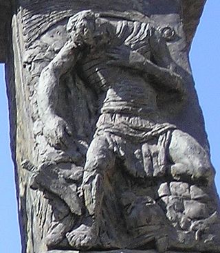
The Bar Kokhba revolt, also known as the Third Jewish Revolt or the 'Jewish Expedition' as the Romans named it, was a rebellion by the Jews of the Roman province of Judea, led by Simon bar Kokhba, against the Roman Empire. The last of the three Jewish–Roman wars, it was fought c. 132–136 CE.

Legio X Fretensis was a legion of the Imperial Roman army. It was founded by the young Gaius Octavius in 41/40 BC to fight during the period of civil war that started the dissolution of the Roman Republic. X Fretensis is then recorded to have existed at least until the 410s.
Moshe Ziffer was an Israeli artist and sculptor.

Salamah was a Palestinian Arab village, located five kilometers east of Jaffa, that was depopulated in the lead-up to the 1948 Arab-Israeli War. The town was named for Salama Abu Hashim, a companion of the Islamic prophet Muhammad. His tomb, two village schools, and ten houses from among the over 800 houses that had made up the village, are all that remain of the structures of the former village today. The historic road from Jaffa to the village is now a street on the border of Tel Aviv and Jaffa, still commonly called "Salameh road".

The Tel Aviv–Jerusalem railway is a railway line in Israel connecting the city of Tel Aviv with Jerusalem. The line serves as the main rail link between the two cities, complementing the old Jaffa–Jerusalem railway. As such, the railway is often referred to in Israel as the high-speed railway to Jerusalem to distinguish it from the older, longer and slower line. In spite of that name, the line is not high-speed under the definition used by the International Union of Railways: both its design speed of 200 km/h (125 mph) and its current operational speed of 160 km/h (99 mph) are below the 250 km/h (155 mph) threshold used by the UIC to define high-speed railways, and it is traversed by IR's regular rolling stock instead of the UIC requirement for specially-designed high-speed trains.

al-Midya is a Palestinian village in the Ramallah and al-Bireh Governorate in the western West Bank, located west of Ramallah. According to the Palestinian Central Bureau of Statistics, the village had a population of over 1,301 inhabitants in 2007.

Rishpon is a moshav in the Central District of Israel. Located in the Sharon plain near Herzliya, it falls under the jurisdiction of Hof HaSharon Regional Council. In 2021 it had a population of 1,483.
Melisende was the hereditary Lady of Arsuf from 1177 and the second wife of the powerful nobleman John, Old Lord of Beirut.

Lajjun was a large Palestinian Arab village located 16 kilometers (9.9 mi) northwest of Jenin and 1 kilometer (0.62 mi) south of the remains of the biblical city of Megiddo. The Israeli kibbutz of Megiddo, Israel was built on the land from 1949.
Following are timelines of the history of Ottoman Syria, taken as the parts of Ottoman Syria provinces under Ottoman rule.

Benjamin Henri Isaac is the Fred and Helen Lessing Professor of Ancient History Emeritus at Tel Aviv University. He is a member of the Israel Academy of Sciences and Humanities and of the American Philosophical Society
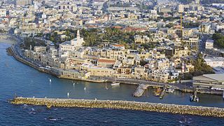
Jaffa, in Hebrew Yafo and in Arabic Yafa and also called Japho or Joppa, is an ancient Levantine port city founded by the Canaanites that is now part of southern Tel Aviv, Israel. Sitting atop a naturally elevated outcrop on the Mediterranean coastline, it was a strategic location that exchanged hands repeatedly in ancient Near East history, and was also contested during the Crusades, when it presided over the County of Jaffa and Ascalon.

The Onomasticon compiled by Eusebius of Caesarea is a directory of place names, or "gazetteer", a primary source that provides historical geographers with a contemporary knowledge of early 4th-century Palestine and Transjordan. It sits uneasily between the ancient genres of geography and lexicography, taking elements from both but serving as a member of neither. It is, according to many, the most important book for the study of Palestine in the Roman period.

The Road of the Patriarchs or Way of the Patriarchs, is an ancient north–south route traversing the land of Israel. The name is used by biblical scholars because of mentions in biblical narratives that it was frequently travelled by Abraham, Isaac and Jacob.
Gerasa (Judaea) was an ancient Jewish town mentioned by the historian Josephus (The Jewish War, 4.9.1) as being sacked by the Imperial Roman army under Lucius Annius during the First Jewish-Roman War.
{{cite web}}: CS1 maint: archived copy as title (link)| International | |
|---|---|
| National | |
| Other | |