Related Research Articles

Guwahati is the biggest city of the Indian state of Assam and also the largest metropolis in northeastern India. Dispur, the capital of Assam, is in the circuit city region located within Guwahati and is the seat of the Government of Assam. A major riverine port city along with hills, and one of the fastest growing cities in India, Guwahati is situated on the south bank of the Brahmaputra. It is called the ''Gateway to North East India''.

The Battle of Saraighat was a naval battle fought in 1671 between the Mughal Empire, and the Ahom Kingdom on the Brahmaputra river at Saraighat, now in Guwahati, Assam, India. Although weaker, the Ahom Army defeated the Mughal Army by massive army, clever diplomatic negotiations to buy time, guerrilla tactics, psychological warfare, military intelligence and by exploiting the sole weakness of the Mughal forces—its navy.
Kamrup Rural district, or simply Kamrup district, is an administrative district in the state of Assam in India formed by dividing the old Kamrup district into two in the year 2003; other being Kamrup Metropolitan district, named after the region it constitutes. This district, along with Nalbari, Barpeta, Kamrup Metropolitan, Bajali and Baksa districts has been created from the Undivided Kamrup district.

Kamarupa, an early state during the Classical period on the Indian subcontinent, was the first historical kingdom of Assam.

The history of Assam is the history of a confluence of people from the east, west, south and the north; the confluence of the Austroasiatic, Tibeto-Burman (Sino-Tibetan), Tai and Indo-Aryan cultures. Although invaded over the centuries, it was never a vassal or a colony to an external power until the third Burmese invasion in 1821, and, subsequently, the British ingress into Assam in 1824 during the First Anglo-Burmese War.

North Guwahati is northern part of the city of Guwahati and a town area committee in Kamrup Rural district in the Indian state of Assam.This town abounds in historical places and picnic spots. National Highway 27 passes through North Guwahati. Amingaon neighbourhood is district headquarter of Kamrup Rural district.

Hajo is a historic town set in the hills northwest of Guwahati, Assam, India. It is a meeting point of Buddhists, Hindus and Muslims due to the various pilgrimage sites on the different hills of Hajo. To the Hindus, the Manikut Parbat of Hajo is the site of the 10th-century temple ruins and the 11th- to 16th-century temples complex for Vaishnavism as well as shrines of Shaivism and Shaktism. To the Buddhists, particularly from Bhutan and Tibet, Assam is where the Buddha died and the Hayagriva temple in Hajo is a part of the sacred geography of the Buddha. To the regional Muslims, the Mughal era Poa-Mecca shrine on another hill of Hajo has the tomb of Giyasuddin Aulia built in the 17th-century.
Ahom–Mughal conflicts refer to the period between the first Mughal attack on the Ahom kingdom in Battle of Samdhara in 1616 till the final Battle of Itakhuli in 1682. The intervening period saw the fluctuating fortunes of both powers and the end of the rule of Koch Hajo. It ended with the Ahom influence extended to the Manas river which remained the western boundary of the kingdom till the advent of the British in 1826.
Borphukan was one of the five patra mantris (councillors) in the Ahom kingdom, a position that was created by the Ahom king Prataap Singha. The position included both executive and judicial powers, with jurisdiction of the Ahom kingdom west of Kaliabor river. The headquarters of Borphukan was based in Kaliabor and after the Battle of Itakhuli in 1681 in Itakhuli in Guwahati. This position was particularly important and powerful because of its distance from the Ahom capital, giving it a semblance of independence. The region to the east of Kaliabor was governed by the Borbarua. Lachit Deka later became Borphukan or the ruler of Lower Assam according to the fifth chronicles of the Satsori Asom Buranji.
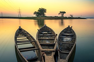
The Sukreswar (Pron: ˌʃʊˈkreɪʃwə) Temple is an important Shiva temple in the state of Assam in India. The temple is located on the Sukreswar or Itakhuli hill on the south bank of river Brahmaputra in the Panbazar locality of Guwahati city. Leading down from the temple compound is a long flight of steps to the river. Sitting on the steps of Sukreswar ghat one can enjoy the scenery of sun setting on the river, boats moving across the river, people performing puja in honour of their relatives who have left this world, children and older people bathing. It has one of the largest Lingam of Lord Shiva.
Pan Bazaar is a locality in Guwahati, India surrounded by localities of Paltan Bazaar, Ambari and Fancy Bazaar. Situated on the banks of the river Brahmaputra, it is part of the city centre.

Assam is the main and oldest state in the North-East Region of India and as the gateway to the rest of the Seven Sister States. The land of red river and blue hills, Assam comprises three main geographical areas: the Brahmaputra Valley which stretching along the length of the Brahmaputra river, the Barak Valley extending like a tail, and the intervening Karbi Plateau and North Cachar Hills. Assam shares its border with Meghalaya, Arunachal Pradesh, Nagaland, Manipur, Tripura, Mizoram and West Bengal; and there are National Highways leading to their capital cities. It also shares international borders with Bhutan and Bangladesh and is very close to Myanmar. In ancient times Assam was known as Pragjyotisha or Pragjyotishpura, and Kamarupa.
Uzan Bazar is a residential and commercial centre of Guwahati and one of the oldest settlements in the city. It is located in the northern part of the city with the river Brahmaputra flowing alongside in north. It houses some of the major tourist as well as sites of regional importance in and around its area. This area is the nearest of the residential areas as far as the river is concerned, is famous for its fish market of fished out varieties from the river.

Kamrup is the modern region situated between two rivers, the Manas and the Barnadi in Western Assam, with the same territorial extent as the Colonial and post-Colonial "Undivided Kamrup district". It was the capital region of two of the three dynasties of Kamarupa and Guwahati, the current political center of Assam, is situated here. It is characterized by its cultural artifacts.
The Battle of Itakhuli was fought in 1682 between the Ahom Kingdom and the Mughal Empire. The Ahoms pushed back Mughal control to the west of the Manas river. The main battle was fought at a garrison island on the Brahmaputra, in which the Mughal fauzdar, Mansur Khan, was defeated and the remnant of the Mughal forces pursued to the Manas river. With this win, the Ahoms recovered Sarkar Kamrup from the Mughals.

Kopili River is an interstate river in Northeast India that flows through the states of Meghalaya and Assam and is the largest south bank tributary of the Brahmaputra in Assam.

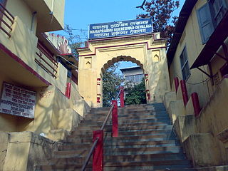
The Northbrook Gate, was constructed to welcome British viceroy Lord Northbrook who visited Guwahati in 1874. The gate was built near Sukreswar Ghat where the viceroy anchored his ship. It is the only monument of its kind in this part of Assam and the lone surviving brick architecture from colonial times. For the last 140 years, it has remained a silent spectator of many developments of Guwahati.

Northeast India consists of the eight states Arunachal Pradesh, Assam, Manipur, Meghalaya, Mizoram, Nagaland, Sikkim and Tripura. Tourism in this area is based around the unique Himalayan landscape and culture distinct from the rest of India.
Assam – 16th largest, 15th most populous and 26th most literate state of the 28 states of the democratic Republic of India. Assam is at 14th position in life expectancy and 8th in female-to-male sex ratio. Assam is the 21st most media exposed states in India. The Economy of Assam is largely agriculture based with 69% of the population engaged in it. Growth rate of Assam's income has not kept pace with that of India's during the Post-British Era; differences increased rapidly since the 1970s. While the Indian economy grew at 6 percent per annum over the period of 1981 to 2000, the same of Assam's grew only by 3.3 percent.

Hinduism is the largest religion of Assam, practiced by around 61% of the state population as per the 2011 Census. Hindus form a majority in 17 out of the 29 districts of Assam. By region, there is a significant diversity among the ethnic groups that profess the Hindu faith, traditions and customs. As per as 2011 Census, In Brahmaputra valley of Assam, Hindus constitute 62% of the population, most being ethnic Assamese. In the autonomous Bodoland region of Assam, Hindus constitute 71.3% of the region's population, most being of the Bodo tribe. In the Barak valley region of southern Assam, Hindus constitute 50% of the region's population, most being ethnic Sylhetis, a subgroup of Bengalis. The Hill Tribes of Assam, particularly the Karbi people of Karbi Anglong and Dimasa people of Dima Hasao are mainly Hindus.
References
- ↑ Patowary, Ajit (26 July 2019). "Govt plan for convention centre, guest house on riverfront resented". Assam Tribune . Archived from the original on 26 July 2019. Retrieved 26 February 2020.
| | This article about a location in the Indian state of Assam is a stub. You can help Wikipedia by expanding it. |