
Bahia is one of the 26 states of Brazil and in the northeast of the country, on the Atlantic coast. It is the fourth-largest Brazilian state by population and the 5th-largest by area. Bahia's capital is the city of Salvador, on a spit of land separating the Bay of All Saints from the Atlantic. Once a monarchial stronghold dominated by agricultural, slaving, and ranching interests, Bahia is now still predominantly a working-class industrial and agricultural state. The state is home to 7% of the Brazilian population and produces 4.2% of the country's GDP.

The São Francisco River is a large river in Brazil. With a length of 2,914 kilometres (1,811 mi), it is the longest river that runs entirely in Brazilian territory, and the fourth longest in South America and overall in Brazil. It used to be known as the Opara by the indigenous people before colonisation, and is today also known as "Velho Chico".
Greenstone belts are zones of variably metamorphosed mafic to ultramafic volcanic sequences with associated sedimentary rocks that occur within Archaean and Proterozoic cratons between granite and gneiss bodies.

Antônio Conselheiro, in English "Anthony the Counselor", real name Antônio Vicente Mendes Maciel was a Brazilian religious leader, preacher, and founder of the village of Canudos, the scene of the War of Canudos (1896–1897), a civil rebellion against the central government which was brutally stamped out with the loss of more than 15,000 lives.

The Bahia coastal forests are a tropical moist broadleaf forest ecoregion of eastern Brazil, part of the larger Atlantic Forest region.
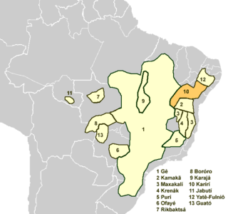
The Karirí languages, generally considered dialects of a single language, are extinct languages formerly spoken by the Kiriri people of Brazil. It was spoken until the middle of the 20th century; the 4,000 ethnic Kiriri are now monolingual Portuguese speakers, though a few know common phrases and names of medicinal plants.
The Itapicuru-Açu River is a river of Bahia state in eastern Brazil.

The Itapicuru-Mirim River is a river of Bahia state in eastern Brazil. It is an important tributary of the Itapicuru River.

Jaguaripe is a municipality in the state of Bahia in the North-East region of Brazil. It covers 863.424 km2 (333.370 sq mi), and has a population of 18,981 with a population density of 18.32 inhabitants per square kilometer. Jaguaripe is located 130 km (81 mi) from the state capital of Bahia, Salvador. Jaguaripe shares a border with the municipalities of Aratuípe, Nazaré, Maragogipe, Laje, São Miguel das Matas, and Santo Antônio de Jesus. It was the first municipality created outside of Salvador, dating to 1693.

Nazaré, also known as Nazaré das Farinhas, is a municipality in the state of Bahia in the North-East region of Brazil. The municipality has a population of 28,594 with a population density of 107 inhabitants per square kilometer. It is located 110 km (68 mi) from the state capital of Bahia, Salvador. Nazaré is within the Bahian Recôncavo, an interior region of the state of Bahia. It borders the municipalities of Muniz Ferreira, Aratuípe, Jaguaripe, São Felipe, and Maragogipe. The Jaguaripe River crosses through the middle of the town. It is sits on the intersection of two Bahian state highways, BA-001 and BA-046.

Acajutiba is a municipality in the state of Bahia in the North-East region of Brazil.
Glória is a municipality in the state of Bahia in the North-East region of Brazil. Glória covers 1,255.56 km2 (484.77 sq mi), and has a population of 15,234 with a population density of 13 inhabitants per square kilometer. It is located on the border of the states of Bahia, Pernambuco, and Alagoas on the banks of the Moxito River, now a lake as the result of the construction of Moxito Hydroelectric Power Plant.

Carinhanha is a municipality in the state of Bahia in the North-East region of Brazil. Carinhanha covers 2,529.45 km2 (976.63 sq mi), and has a population of 29,070 with a population density of 12 inhabitants per square kilometer. It is located on the banks of the Rio São Francisco and the Carinhanha River, which also forms the border of the state of Minas Gerais.

Feira da Mata is a municipality in the state of Bahia in the North-East region of Brazil. Feira da Mata covers 1,176.105 km2 (454.097 sq mi), and has a population of 5,661 with a population density of 5 inhabitants per square kilometer. It was originally part of Carinhanha, but became an independent municipality in 1989.

The Kamakã languages are a small family of extinct Macro-Jê languages of Bahía, northeastern Brazil. The attested Kamakã languages are:

Mission Nuestra Señora del Espíritu Santo de Zúñiga, also known as Aranama Mission or Mission La Bahía, was a Roman Catholic mission established by Spain in 1722 in the Viceroyality of New Spain—to convert native Karankawa Indians to Christianity. Together with its nearby military fortress, Presidio La Bahía, the mission upheld Spanish territorial claims in the New World against encroachment from France. The third and final location near Goliad, Texas is maintained now as part of Goliad State Park and Historic Site.
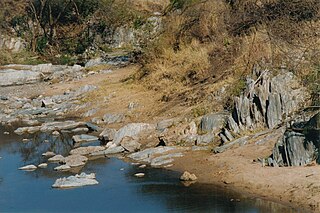
Erythrinus kessleri is a species of trahira. It is a tropical, freshwater fish which is known from coastal rivers in Bahia, Brazil; the type locality is the Itapicuru River. It was described by Franz Steindachner in 1877. Males can reach a maximum standard length of 19 centimetres.
The Peixe River is a river in Bahia state in eastern Brazil. It is a tributary of the Itapicuru River in the municipality of Queimadas.
