This article relies largely or entirely on a single source .(March 2025) |
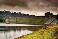
| Iturranduz Dam | |
|---|---|
 | |
| Location | Navarre, Spain |
| Coordinates | 42°36′31″N1°53′44″W / 42.60861°N 1.89556°W |
| Opening date | 2nd / 3rd–4th century |
| Dam and spillways | |
| Impounds | San Pedro (Ebro basin) |
| Height | >4.0 / ? m |
| Length | 102.0 / 150.0 m |
| Width (base) | 1.0 / 0.7 m |
The Iturranduz Dam was a Roman buttress dam in Navarra, Spain. It consisted of two dams, one dating to the 2nd, the other to the 3rd or 4th century AD. [1]