
Iulia Traducta was a Roman city in Andalusia, Spain, on the site of the modern Algeciras.
Iulia Traducta was a Roman city in Andalusia, Spain, on the site of the modern Algeciras.
The location of the city of Iulia Traducta has been widely debated by historians. The traditional hypothesis identified the city of Iulia Traducta with the town of Tarifa, or a location within that municipality. [1] According to Pliny the town was in Mauretania, on the African coast. Strabo, calling it Iulia Ioza, says it was on the Mediterranean coast of Hispania Baetica. Some historians have even identified Iulia Traducta with the town of Baelo Claudia in Baetica. [2]
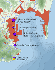
However, the latest research and the discovery of several important archaeological sites in the neighboring city of Algeciras have caused investigators to reconsider the matter. One of the most important sources for determining the location of various cities of Hispania was the Antonine Itinerary, a description of the Roman municipalities along the various roads of the time. This document does not name the city of Iulia Traducta in the Bay of Gibraltar, [3] but in the place that it should occupy, halfway between Carteia and Mellaria, it places Portus Albus. The Ravenna Cosmography places the mansion of Transducta between Gartegia (Carteia) and Cetraria (Caetaria), identified as being respectively in the north and south of Algeciras Bay, but does not name Portus Albus. The hypothesis most widely accepted today is that Portus Albus stood within the present town of Algeciras, north of the city of Iulia Traducta in the old town. However, we must not dismiss the possibility that Portus Albus was a vernacular name of the city, or the name given to its port. [4] [5]
The city is named by classical sources such as Pliny the Elder, Marcian of Heraclea and Pomponius Mela. However Pliny, in an obscure or inaccurate passage, places the city in Mauritania. [6] According to Strabo, between 33 and 25 BC part of the population of the North African city of Colonia Iulia Constantia Zilitanorum (Zilis) was moved to the Iberian peninsula and settled at Iulia Traducta. [lower-alpha 1] [7] Strabo also notes that some people were moved from Tingi (modern Tangier), so the town was also called Tingentera, a contraction of Tingis Altera, or "the other Tangier". [7] The historian Pomponius Mela [8] was born in Tingentera, which he said was founded after the transfer of the populations of Zilis and Tingis to the peninsula. Coins issued in Tingis have the inscription Tingis Maior ("Greater Tingis"), suggesting the existence of a Tingis Minor or Tingis Altera.
According to modern historians the foundation of the city was an attempt by the emperor Octavian to create a strong city of his supporters in an area of Betica (Andalusia) that had overwhelmingly supported Pompey during the Civil War. For this purpose, he moved the population of Zilis to the peninsula. Iulia Traducta was inhabited by veterans as well as by the people from Zilis.

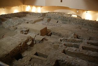
The city's economy included fishing and preparing salt fish, as shown by the industrial complex located in today's San Nicolas street of the Villa Vieja (Old Town) of Algeciras. It dates from the first century until probably late fifth or early sixth centuries. [9] Many millstones were found in five fish-processing factories, and many traces of fish, but very few bones. This suggests that the factories were involved in grinding down the bones to manufacture flours of fish. [10] The salting factory stretched across much of the Villa Vieja, from San Nicolas street probably to the south of the Hotel Reina Cristina. The remains of the salting vats have been located at the foot of the medieval towers of the Villa Vieja, confirming the extent of the complex. [11]
In the first century BC Iulia Traducta had a mint which has left abundant coins (dupondios, asses, semisses and quadrants), clearly showing the importance of the fishing and industry of the town, issued between the years 12 and 10 BC. Creation of this mint was part of the propaganda drive by Octavius to show the divine character of the emperor. The coins minted in the city showed the image of the emperor, his sons Gaius and Lucius and the priestly attributes of princeps of Rome. It also showed symbols related to the economy of the city such as tuna. [12]
It is possible that part of the population also undertook the manufacture of wine, since many amphorae intended for this purpose have been found. The production of amphora in Traducta Iulia has been considered minor due to the existence of a major complex for manufacturing amphorae in the neighboring city of Portus Albus, but nevertheless there were potteries in Traducta judging by some findings around the beach of Chorruelo next to the factories and nearby lands south of the factories. [13] These kilns for making the amphorae have been dated to the first century AD. They may have replaced kilns located in Portus Albus that had been abandoned at that time. From this it would seem that there was an increase in the economic importance of the city at the expense of nearby Carteia, whose amphorae production depended on manufactures of Portus Albus. [14]
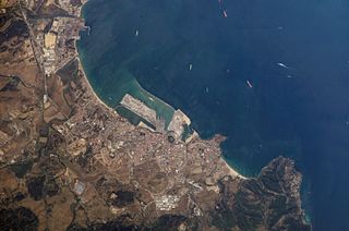
The extent of Iulia Traducta is unknown, although it is supposed to have occupied the Villa Vieja of Algeciras. The area where material has been found extends to the lower part of the Villa Nueva on land beside the Río de la Miel. The river's estuary, now silted up by alluvial deposits, served as a port for landing fish.
The History of the Franks by Gregory of Tours says that Iulia Traducta is where the Vandals boarded their vessels when they invaded Africa in the year 429. [15] [16] [lower-alpha 2] After that date there are no more classical sources, implying that Iulia Traducta was abandoned until the Muslim invasion of Spain in the year 711. However, in recent years structures from the Byzantine period have been found in the Villa Vieja, including a cemetery dating from the sixth century. There have also been found the remains of amphora production and even a Byzantine chalice near the later Muslim mosque. From this is can be said that the city was not completely abandoned at any time, and even when the Arab invasion occurred the resident population of town was probably the most important in the area of the Strait of Gibraltar. [18]

Cádiz is a province of southern Spain, in the southwestern part of the autonomous community of Andalusia. It is the southernmost part of mainland Spain, as well as the southernmost part of continental Europe.
Tarifa is a Spanish municipality in the province of Cádiz, Andalusia. Located at the southernmost end of the Iberian Peninsula, it is primarily known as one of the world's most popular destinations for windsports. Tarifa lies on the Costa de la Luz and across the Strait of Gibraltar facing Morocco.
Algeciras is a municipality of Spain belonging to the province of Cádiz, Andalusia. Located in the southern end of the Iberian Peninsula, near the Strait of Gibraltar, it is the largest city on the Bay of Gibraltar.
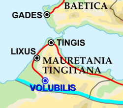
Tingis or Tingi, the ancient name of Tangier in Morocco, was an important Carthaginian, Moor, and Roman port on the Atlantic Ocean. It was eventually granted the status of a Roman colony and made the capital of the province of Mauretania Tingitana and, after Diocletian's reforms, the diocese of Hispania.

San Roque is a municipality of Spain belonging to the province of Cádiz, which in turn is part of the autonomous community of Andalusia. It is also part of the comarca of Campo de Gibraltar. Located in the southern end of the Iberian Peninsula, San Roque is a short way inland of the north side of the Bay of Gibraltar, to the north of the Gibraltar peninsula. The municipality has a total surface of 145 km2 with a population of approximately 25,500 people, as of 2005.
The Port of Algeciras is the port and harbour of Algeciras, a city located in the province of Cádiz in the autonomous community of Andalusia, Spain. It is a commercial, fishing and passenger port. Primarily a transshipment port, its position near the Strait of Gibraltar and key east–west shipping routes establishes it as one of the busiest transshipment hubs in the world. It competes with Tanger-Med for the local transshipment market. It consists of numerous maritime infrastructures scattered throughout the Bay of Gibraltar. Although only the town of Algeciras and La Línea de la Concepción overlook the bay, there are port facilities in the rest of the bank, also belonging to the municipalities of San Roque and Los Barrios. It is managed along the port of Tarifa by the Port Authority of Algeciras Bay.
Abyla was the pre-Roman name of Ad Septem Fratres. Ad Septem Fratres, usually shortened to Septem or Septa, was a Roman colony in the province of Mauretania Tingitana and a Byzantine outpost in the exarchate of Africa. Its ruins are located within present-day Ceuta, an autonomous Spanish city in northwest Africa.
Campo de Gibraltar is a comarca (county) in the province of Cádiz, Spain, in the southwestern part of the autonomous community of Andalusia, the southernmost part of mainland Europe. It comprises the municipalities of Algeciras, La Línea de la Concepción, San Roque, Los Barrios, Castellar de la Frontera, Jimena de la Frontera, San Martín del Tesorillo and Tarifa.

Rusadir was an ancient Punic and Roman town at what is now Melilla, Spain, in northwest Africa. Under the Roman Empire, it was a colony in the province of Mauretania Tingitana.

Carteia was a Phoenician and Roman town at the head of the Bay of Gibraltar in Spain. It was established at the most northerly point of the bay, next to the town of San Roque, about halfway between the modern cities of Algeciras and Gibraltar, overlooking the sea on elevated ground at the confluence of two rivers, nowadays called Guadarranque and Cachon.

The history of Moorish Gibraltar began with the landing of the Muslims in Hispania and the fall of the Visigothic Kingdom of Toledo in 711 and ended with the fall of Gibraltar to Christian hands 751 years later, in 1462, with an interregnum during the early 14th century.

The Torre de los Adalides was a rectangular medieval look-out tower of Islamic design located in the vicinity of Algeciras, Spain. It was situated roughly 1 kilometre (0.62 mi) from the coast on a hill some 100 metres (330 ft) above sea level in the area which is now covered by the city's northern suburbs. The tower was demolished by the Spaniards during the Spanish–American War as they thought the Americans might use it as a base of their own. The ruins of the tower are within military limits and cannot be approached without a formal permit.

Municipal Museum of Algeciras is a museum in Algeciras, Spain, located at the northern end of the Parque de las Acacias de Algeciras. It was established in 1995 and is run by the city's cultural department. It houses a large collection of archaeological items which were found in different parts of the city. With its two main divisions, archaeology and history, the museum documents three periods in the city's history: Roman-Byzantine Algeciras, the Andalusian city, and the modern era. A third division, religious art, is located in the Capilla del Cristo de la Alameda.

The Roman kilns of El Rinconcillo were Roman kilns located in the Spanish city of Algeciras. They were part of manufacturing complex of Portus Albus, which supplied container for transport to the processing industry of the neighboring city of Iulia Traducta, besides making other ceramic household products and items.
The siege of Algeciras (1342–1344) was undertaken during the Reconquest of Spain by the Castillian forces of Alfonso XI assisted by the fleets of the Kingdom of Aragon and the Republic of Genoa. The objective was to capture the Muslim city of Al-Jazeera Al-Khadra, called Algeciras by Christians. The city was the capital and the main port of the European territory of the Marinid Empire.

The siege of Algeciras (1369) was undertaken during the period of the Reconquest of Spain by Muhammad V, the Emir of Granada to reclaim the city of Al-Hadra Al-Yazirat, called Algeciras by the Christians, in the Kingdom of Castile. The siege lasted just three days, and the sultan was victorious. The Muslims thus regained a major city which had been in Castilian hands since Alfonso XI of Castile took it from the Moroccans after the long 1342–1344 siege. Ten years after the capture of the city, in 1379 the sultan of Granada decided to completely destroy the city to prevent it falling into Christian hands. It was impossible to defend the place at a time when the Muslim kings of the Iberian Peninsula had lost much of military power they enjoyed in earlier centuries.
Mellaria was a Roman settlement in Hispania Baetica, on the coast of the Strait of Gibraltar in what is now the Province of Cádiz in Spain. The fish processing plant is mentioned by Strabo under the name Menlaria. There is some debate about its location, but it has been identified with the modern town of Tarifa, but more probably with Valdevaqueros.

The toponym al-Andalus (الأندلس) is first attested in inscriptions on coins minted by the Umayyad rulers of Iberia, from ca. 715.
The Battle of the Strait was a military conflict contesting the ports in the Straits of Gibraltar taking place in the late thirteenth century and the first half of the fourteenth. The conflict involves principally the Spanish Muslim Emirate of Granada, the Spanish Christian Crown of Castile and the North African Muslim Marinid state. The ports' strategic value came from their position linking Spain and North Africa, thus connecting Muslims in Spain with the rest of the Islamic world. The campaign had mixed results. Castile gained Tarifa permanently, and managed to take Gibraltar and Algeciras but both would revert to Muslim rule. Castile also failed to gain any port in the African side of the strait.
The history of Algeciras, a Spanish region, can be traced back to initial Paleolithic outdoor settlements. In antiquity, Algeciras was home to two significant settlements: the Roman city of Iulia Traducta, which served as an important commercial hub, and the city of Al-Yazira al-Jadra, the first Arab settlement established in the peninsula. Following a three-century period of abandonment, a new city of Algeciras was re-founded in 1704.