[[Carthage|Carthaginian]]
[[Ancient Rome|Roman]]"},"dependency_of":{"wt":""},"occupants":{"wt":""},"event":{"wt":""},"excavations":{"wt":""},"archaeologists":{"wt":""},"condition":{"wt":"Partially excavated remains"},"ownership":{"wt":""},"management":{"wt":""},"public_access":{"wt":"Yes"},"website":{"wt":""},"notes":{"wt":""}},"i":0}}]}" id="mwBg">.mw-parser-output .infobox-subbox{padding:0;border:none;margin:-3px;width:auto;min-width:100%;font-size:100%;clear:none;float:none;background-color:transparent}.mw-parser-output .infobox-3cols-child{margin:auto}.mw-parser-output .infobox .navbar{font-size:100%}body.skin-minerva .mw-parser-output .infobox-header,body.skin-minerva .mw-parser-output .infobox-subheader,body.skin-minerva .mw-parser-output .infobox-above,body.skin-minerva .mw-parser-output .infobox-title,body.skin-minerva .mw-parser-output .infobox-image,body.skin-minerva .mw-parser-output .infobox-full-data,body.skin-minerva .mw-parser-output .infobox-below{text-align:center}@media screen{html.skin-theme-clientpref-night .mw-parser-output .infobox-full-data:not(.notheme)>div:not(.notheme)[style]{background:#1f1f23!important;color:#f8f9fa}}@media screen and (prefers-color-scheme:dark){html.skin-theme-clientpref-os .mw-parser-output .infobox-full-data:not(.notheme) div:not(.notheme){background:#1f1f23!important;color:#f8f9fa}}@media(min-width:640px){body.skin--responsive .mw-parser-output .infobox-table{display:table!important}body.skin--responsive .mw-parser-output .infobox-table>caption{display:table-caption!important}body.skin--responsive .mw-parser-output .infobox-table>tbody{display:table-row-group}body.skin--responsive .mw-parser-output .infobox-table tr{display:table-row!important}body.skin--responsive .mw-parser-output .infobox-table th,body.skin--responsive .mw-parser-output .infobox-table td{padding-left:inherit;padding-right:inherit}}
![]() Roman forum in Carteia. | |
Location | San Roque, Province of Cádiz, Andalusia, Spain |
---|---|
Coordinates | 36°11′08″N5°24′30″W / 36.185524°N 5.408301°W |
Type | Settlement |
History | |
Founded | 940 BC |
Cultures | Phoenician Carthaginian Roman |
Site notes | |
Condition | Partially excavated remains |
Public access | Yes |
Carteia (Ancient Greek : Καρτηίᾳ) [1] was a Phoenician and Roman town at the head of the Bay of Gibraltar in Spain. It was established at the most northerly point of the bay, next to the town of San Roque, about halfway between the modern cities of Algeciras and Gibraltar, overlooking the sea on elevated ground at the confluence of two rivers, nowadays called Guadarranque and Cachon. [2]
According to Strabo, it was founded around 940 BC as the trading settlement of Kʿrt (meaning "city" in the Phoenician language; compare Carthage and Cartagena).[ clarification needed ] The area had much to offer a trader; the hinterland behind Carteia, in the modern south of Andalusia, was rich in wood, cereals, oranges, lemons, lead, iron, copper and silver. Dyes were another much sought-after commodity, especially those from the murex shellfish, used to make the prized Tyrian purple. [3] Strabo and Pomponius Mela, mention that some believe that Carteia used to be the Tartessos. [4] [5] Pliny the Elder writes that Carteia was called by the Greeks Tartessos. [6]
The town's strategic location meant that it played a significant role in the wars between Carthage and the Roman Republic in the 2nd and 3rd centuries BC. It may have been the site of Hamilcar's landing with his army and elephants in 237 BC, and in 206 BC the Carthaginian admiral Adherbal retreated there with the remnants of his fleet after being defeated by Gaius Laelius in the Battle of Carteia. Around 190 BC, the town was captured by the Romans. [3]
Livy records that in 171 BC, the Roman Senate was petitioned by a group of Romano-Spanish people, the sons of Roman soldiers and Spanish women. Although they were of Roman descent they were not regarded as Roman citizens, nor were they allowed to marry Roman citizens. The Senate responded by elevating Carteia to the status of a colonia (Roman colony) and granting around 4,000 Romano-Spanish people the right to live there and receive a grant of land on a similar basis to Roman colonists.
The existing inhabitants were permitted to remain there, while all of the inhabitants were given the right to marry Roman citizens and to carry on trade with Romans. This marked a significant innovation for Rome's overseas colonies; the Carteians were the first outside Italy to receive a civic status known as the Latin Rights, halfway between being a non-citizen provincial and a full Roman citizen. Other cities in Spain were later granted a similar status. [7]
The Colonia Libertinorum Carteia (Freedmen's Colony of Carteia) prospered for another 580 years under Roman rule. [3] It grew to become a substantial city which served as a centre for the export of local wines, shipped in amphorae fired in large kilns found on the site, and the manufacture of garum fish sauce. [8] Carteia acquired a mint, amphitheatre, temples and port, and played a significant role in late Roman Republican affairs. Pompey made it his western base for his campaign against Mediterranean pirates in 68 BC. His sons Gnaeus and Sextus raised an army there in 45 BC before being defeated by Julius Caesar at the Battle of Munda. While Gnaeus was captured and executed, Sextus escaped via Carteia's port and fled north to the Pyrenees. [3]
Little is known of the remainder of Carteia's Roman history, but it appears to have been sacked by the Visigoths around 409 AD, by which time it was probably already in decline. [9] Nonetheless, archaeological evidence shows that urban life continued there into the medieval period. The foundations of an early Christian basilica have been found, [8] a Visigothic necropolis exists near one of the Roman temples, and Byzantine remains discovered at the site show its continued occupation when Carteia was incorporated into the Byzantine province of Spania during the 6th-7th centuries.
In the 9th century, after the Umayyad conquest of Hispania, Islamic sources referred to the town – which was probably not much more than a village by then – as Qartayanna or Cartagena. The Marinids constructed a tower nearby, known today as the Torre de Cartagena, using stones from the ruined Roman walls. [10]
The site of Carteia was rediscovered by a young British Army officer, John Conduitt, who served in Gibraltar as commissary to the garrison between April 1713 to early 1717. He identified the city as having stood on a hill then known as El Rocadillo, which Richard Ford described in his A Handbook for Travellers in Spain (1845):
The coast road is intersected by the rivers Guadaranque and Palmones; on crossing the former is the eminence El Rocadillo, now a farm, and corn grows where once Carteia flourished ... The remains of an amphitheatre, and the circuit of walls about 2 miles, may yet be traced. The Moors and Spaniards have alike destroyed the ruins, working them up as a quarry in building Algeciras and San Roque. The coins found here are very beautiful and numerous ... Mr. Kent, of the port-office at Gibraltar, formed a Carteian museum, consisting of medals, pottery, glass, &c. [11]
Conduitt communicated his discovery to the Royal Society in London and was invited to read a paper on Carteia on his return to the capital. He did so on 20 June 1717, with Sir Isaac Newton in attendance as chair. Coincidentally, Newton was also interested in Carteia, as he was in the middle of writing his work The Chronology of Ancient Kingdoms , and he invited Conduitt to his home to discuss the ancient city. It was there that Conduitt met Newton's niece, Catherine Barton. After a whirlwind courtship the two were married on 26 August 1717, though Barton was almost a decade older than Conduitt, albeit still renowned for her beauty. [12] [13]
An early 19th-century writer, the anonymous "Calpensis", described how he had "often walked over the site of Carteia, attracted by the rich variety of broken pieces of marble scattered over the fields. Part of the wall enclosing the farm-house was then rudely made up of broken pillars, columns and cornices, of marble of the finest workmanship." [2]
Some of the earliest excavations were carried out at the behest of the British; in 1811–12, Vice-Admiral Charles Penrose reached agreement with the estate's owners to allow amateur antiquarians from Gibraltar to "excavate and examine any part of its ground for antiquities." [2] The excavations found the remains of a tessellated Roman pavement, which was thought to belong to a temple, as well as foundations of Roman buildings. [2]
Although the area around Carteia was open farmland in the time of "Calpensis", it is now heavily industrialised. The site of Carteia is surrounded on three sides by an oil refinery. It was not given protection until as late as the 1960s, by which time the necropolis and city gates had been lost to encroaching development. However, the main urban area has been preserved and can be visited. A number of significant structures can still be seen, including the original Carthaginian city gate, a monumental sandstone flight of steps leading down to what was possibly the forum, a large temple, a number of houses and an extensive Roman baths. The 16th century Torre de Rocadillo can also be seen. [10] From 1971 to 1974, excavations were carried out which found part of a bust of the Emperor Augustus and a headless statue of a man wearing a toga. [10] The Carteia Archaeological Museum in San Roque displays archaeological finds from the site. [10]
Year 211 BC was a year of the pre-Julian Roman calendar. At the time it was known as the Year of the Consulship of Maximus and Maximus. The denomination 211 BC for this year has been used since the early medieval period, when the Anno Domini calendar era became the prevalent method in Europe for naming years.
Tartessos is, as defined by archaeological discoveries, a historical civilization settled in the southern Iberian Peninsula characterized by its mixture of local Paleohispanic and Phoenician traits. It had a writing system, identified as Tartessian, that includes some 97 inscriptions in a Tartessian language.
Empúries was an ancient Greek city on the Mediterranean coast of Catalonia, Spain. The city Ἐμπόριον was founded in 575 BC by Greeks from Phocaea. After the invasion of Gaul from Iberia by Hannibal the Carthaginian general in 218 BC, the city was occupied by the Romans. In the Early Middle Ages, the city's exposed coastal position left it open to marauders and it was abandoned.
Tarraco is the ancient name of the current city of Tarragona. It was the oldest Roman settlement on the Iberian Peninsula. It became the capital of Hispania Tarraconensis following the latter's creation during the Roman Empire.
The Turduli or Turtuli were an ancient pre-Roman people of the southwestern Iberian Peninsula.
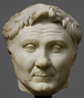
The gens Pompeia was a plebeian family at ancient Rome, first appearing in history during the second century BC, and frequently occupying the highest offices of the Roman state from then until imperial times. The first of the Pompeii to obtain the consulship was Quintus Pompeius in 141 BC, but by far the most illustrious of the gens was Gnaeus Pompeius, surnamed Magnus, a distinguished general under the dictator Sulla, who became a member of the First Triumvirate, together with Caesar and Crassus. After the death of Crassus, the rivalry between Caesar and Pompeius led to the Civil War, one of the defining events of the final years of the Roman Republic.
San Roque is a municipality of Spain belonging to the province of Cádiz, which in turn is part of the autonomous community of Andalusia. It is also part of the comarca of Campo de Gibraltar. Located in the southern end of the Iberian Peninsula, San Roque is a short way inland of the north side of the Bay of Gibraltar, to the north of the Gibraltar peninsula. The municipality has a total surface of 145 km2 with a population of approximately 25,500 people, as of 2005.
Kamarina or Camarina was an ancient city on the southern coast of Sicily in Magna Graecia. The ruins of the site and an archaeological museum are located south of the modern town of Scoglitti, a frazione (borough) of the comune (municipality) of Vittoria in the province of Ragusa.
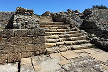
Baelo Claudia was an ancient Roman town in Hispania, located 22 kilometres (14 mi) outside of Tarifa, near the village of Bolonia, in southern Spain. On the shore of the Strait of Gibraltar, the town was originally a fishing village and trade link when it was settled approximately 2,000 years ago. Although prosperous at the time of Emperor Claudius, it went into a decline partially fueled by earthquakes and was abandoned by the 6th century.
Lucentum, called Lucentia by Pomponius Mela, is the Roman predecessor of the city of Alicante, Spain. Particularly, it refers to the archaeological site in which the remains of this ancient settlement lie, at a place known as El Tossal de Manises, in the neighborhood of Albufereta.
Mainake, Menace was an ancient Greek settlement lying in the southeast of Spain, according to the Greek geographer and historian Strabo (3,4,2) and Pausanias of Damascus. Pausanias adds that it was a colony of the Greek city of Massalia. Maria Eugenia Aubet locates it at the site of modern Málaga. The first colonial settlement in the area, dating from the late 8th century BC, was made by seafaring Phoenicians from Tyre, Lebanon, on an islet in the estuary of the Guadalhorce River at Cerro del Villar.
Lora de Estepa is a city located in the province of Seville, Spain. According to the 2006 census (INE), the city has a population of 831 inhabitants.
Mastia is an ancient Iberian settlement, belonging to the Tartessian confederation, once located in southeastern Spain. It has traditionally been associated with the city of Cartagena (Spain). The association has been made principally from the analysis of classical sources in the early 20th century by Adolf Schulten.
The Punic wall of Cartagena is an archaeological site from the 3rd century BC in which can be seen the first defensive wall of Cartagena, built by the Carthaginians.
The Battle of Carteia was a naval battle of the Second Punic War, fought between the navy of the Roman Republic and a Carthaginian fleet in 206 BC near the ancient city of Carteia in southern Spain. The Roman navy was commanded by Gaius Laelius and the Carthaginian navy by Adherbal. The battle resulted in a Roman victory.
The Battle of Carteia, also known by the modern name Battle of the Guadalquivir, took place during the Second Punic War in 206 BC between the forces of Carthage and the Roman Republic. The name "Battle of the Guadalquivir" is anachronistic, since the river's name "el Guadalquivir", from the Arabic al-wadi al-kabir, was not used until the Islamic conquest of Spain over nine hundred years after the battle. The Carthaginian forces were commanded by Hanno and the Romans by Gaius Lucius Marcius Septimus. The battle resulted in a Roman victory.
Iulia Traducta was a Roman city in Andalusia, Spain, on the site of the modern Algeciras.
Mellaria was a Roman settlement in Hispania Baetica, on the coast of the Strait of Gibraltar in what is now the Province of Cádiz in Spain. The fish processing plant is mentioned by Strabo under the name Menlaria. There is some debate about its location, but it has been identified with the modern town of Tarifa, but more probably with Valdevaqueros.
The Battle off Carteia was a minor naval battle during the latter stages of Caesar's civil war won by the Caesarians led by Caesar's legate Gaius Didius against the Pompeians led by Publius Attius Varus.
The history of Algeciras, a Spanish region, can be traced back to initial Paleolithic outdoor settlements. In antiquity, Algeciras was home to two significant settlements: the Roman city of Iulia Traducta, which served as an important commercial hub, and the city of Al-Yazira al-Jadra, the first Arab settlement established in the peninsula. Following a three-century period of abandonment, a new city of Algeciras was re-founded in 1704.