Related Research Articles

Collier County is a county in the U.S. state of Florida. As of the 2020 census, its population was 375,752; an increase of 16.9% since the 2010 United States Census. Its county seat is East Naples, where the county offices were moved from Everglades City in 1962.

DeSoto County is a county located in the Florida Heartland region of the U.S. state of Florida. As of the 2020 census, the population was 33,976. Its county seat is Arcadia.

Glades County is a county located in the Florida Heartland region of the U.S. state of Florida. As of the 2020 census, the population was 12,126, making it the fourth-least populous county in Florida. Its county seat is Moore Haven.

Highlands County is a county located in the Florida Heartland region of the U.S. state of Florida. As of the 2020 census, the population was 101,235. Its county seat is Sebring.

Okeechobee County is a county located in the Florida Heartland region of the state of Florida. As of the 2020 census, the population was 39,644. The county seat is Okeechobee.

Lake Buena Vista is a city in Orange County, Florida, United States. It is mostly known for being the mailing address for Walt Disney World—although almost all of the resort facilities, including all four theme parks, are physically located in the adjacent city of Bay Lake. It is one of two Florida municipalities inside the Central Florida Tourism Oversight District, which also contains Walt Disney World, the other being Bay Lake. The permanent residential population of Lake Buena Vista was 24 at the 2020 census.

The Eastern Continental Divide, Eastern Divide or Appalachian Divide is a hydrographic divide in eastern North America that separates the easterly Atlantic Seaboard watershed from the westerly Gulf of Mexico watershed. The divide nearly spans the United States from south of Lake Ontario through the Florida peninsula, and consists of raised terrain including the Appalachian Mountains to the north, the southern Piedmont Plateau and lowland ridges in the Atlantic Coastal Plain to the south. Water including rainfall and snowfall, lakes, streams and rivers on the eastern/southern side of the divide drains to the Atlantic Ocean; water on the western/northern side of the divide drains to the Gulf of Mexico. The ECD is one of six continental hydrographic divides of North America which define several drainage basins, each of which drains to a particular body of water.
Holopaw is an unincorporated community in Osceola County, Florida, United States. It is located at the eastern end of the multiplex of highways US 192 and US 441. It has a population of fewer than 5,000 people and is part of the Orlando-Kissimmee Metropolitan Statistical Area.

The 74-mile-long (119 km) Ocklawaha River flows north from central Florida until it joins the St. Johns River near Palatka. Its name is derived from ak-lowahe, Creek for "muddy".
The Tampa Bypass Canal and Palm River are a 14-mile-long (23 km) flood bypass operated by the Southwest Florida Water Management District. The canal includes several concrete flood control structures and was constructed during the 1960s and 1970s. Its purpose is to redirect flood waters from large amounts of rainfall from the Hillsborough River to Tampa Bay to prevent floodwaters reaching homes and businesses. Despite its original purpose it is now used as a drinking water source for the City of Tampa. During construction of the canal the Floridan aquifer was accidentally breached.
The Southwest Florida Water Management District, is one of five regional agencies directed by Florida state law to protect and preserve water resources. Established in 1961 the agency operates and maintains several large properties and flood protection projects, sometimes with other agencies. The District's responsibilities have expanded to include managing water supply and protecting water quality and the natural systems — rivers, lakes, wetlands and associated uplands.The District's stated mission is to protect water resources, minimize flood risks and ensure the public’s water needs are met.

Black Creek is a tributary of the St. Johns River in Clay County, Florida. It is formed by the confluence of North Fork Black Creek and South Fork Black Creek. North Fork Black Creek originates as an outflow from Kingsley Lake and flows north and then southeast, meeting South Fork Black Creek on the east side of MIddleburg. North Fork Black Creek has Yellow Water Creek as its main tributary. South Fork Black Creek originates in a chain of lakes about four miles south of Kingsley Lake, with Ates Creek, Bull Creek, and Greens Creek as its main tributaries. Both forks are fed by areas of wetlands and numerous small streams.
Deep Creek Preserve is located in DeSoto County. The 2,000-acre (8.1 km2) area serves as a water conservation resource and offers opportunities for a range of activities. It is located at 10797 SW Peace River Street in Arcadia. It is part of the Southwest Florida Water Management District.
The Green Swamp is a swamp in Florida. It lies west of Highway 27 and east of Interstate 75 in Polk, Lake, Sumter, Hernando and Pasco Counties. The headwaters of the Peace River, Withlacoochee River, Ocklawaha River, and Hillsborough River are located here.
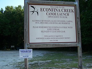
Econfina Creek is a small river in the middle Florida Panhandle. It flows through hilly country, and has sections of whitewater rapids. Much of its flow comes from springs. The river ends at Deer Point Lake, a reservoir that provides the freshwater supply for Panama City and much of Bay County.
Blackwater Creek is an approximately 19 mile riverine feature in Florida. The creek flows from Lake Norris and has a confluence with the Wekiva River near where it in turn flows into the St. Johns River. The upper sections of Black Creek are traversed by kayak and canoe. Other sections a difficult to navigate due to snags.
Deep Creek Conservation Area is an area of protected lands near Hastings, Florida in St. Johns County and Putnam County that is managed by the St. Johns River Water Management District.
Deep Creek State Forest (DCSF) is a 380-acre state forest 11 miles north of St. Augustine, Florida in St. Johns County, Florida. Deep Creek State Forest is located on both sides of Deep Creek, for which it is named. The state forest is west of the Guana River Wildlife Management Area across the Intracoastal Waterway.
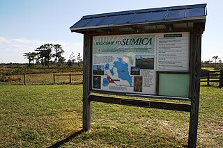
Sumica, alternatively written as SUMICA, was a mill town in Polk County, Florida. The ghost town is commemorated by a historical marker off S.R. 60. There is also a Southwest Florida Water Management District preserve in the area named for the former logging settlement and mill town. Goods from a company store in the town could be purchased with company issued currency, including 25 cent and 5 cent scrip.
References
- ↑ Jack Creek Southwest Florida Water Management Area
27°21′43″N81°25′21″W / 27.362007°N 81.422389°W