
Shropshire is a landlocked county in the West Midlands region of England. It is bordered by Wales to the west and the English counties of Cheshire to the north, Staffordshire to the east, Worcestershire to the southeast, and Herefordshire to the south. Shropshire Council was created in 2009, a unitary authority taking over from the previous county council and five district councils, covering Shropshire district. The borough of Telford and Wrekin has been a separate unitary authority since 1998, but remains part of the ceremonial county.

Church Stretton is a market town in Shropshire, England, 13 miles (21 km) south of Shrewsbury and 15 miles (24 km) north of Ludlow. The population in 2011 was 4,671.

John "Mad Jack" Mytton was a British eccentric and rake of the Regency period who was briefly a Tory Member of Parliament.

Clun is a small town in south west Shropshire, England, and the Shropshire Hills Area of Outstanding Natural Beauty. The 2011 census recorded 680 people living in the town. Research by the Campaign for the Protection of Rural England suggests that Clun is one of the most tranquil locations in England.

Much Wenlock is a market town and parish in Shropshire, England, situated on the A458 road between Shrewsbury and Bridgnorth. Nearby, to the northeast, is the Ironbridge Gorge, and the new town of Telford. The civil parish includes the villages of Homer, Wyke, Atterley, Stretton Westwood and Bourton. The population of the civil parish, according to the 2001 census, was 2,605, increasing to 2,877 at the 2011 Census. Notable historic attractions in the town are Wenlock Priory and the Guildhall.

Craven Arms is a market town and civil parish in Shropshire, England, on the A49 road and the Welsh Marches railway line, which link it north and south to the larger towns of Shrewsbury and Ludlow respectively. The Heart of Wales railway line joins the Welsh Marches line at Craven Arms and the town is served by Craven Arms railway station. The town is enclosed to the north by the Shropshire Hills Area of Outstanding Natural Beauty, and to the south is the fortified manor house of Stokesay Castle.

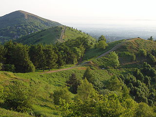
Wenlock Edge is a limestone escarpment near Much Wenlock, Shropshire, England and a site of special scientific interest because of its geology. It is over 19 mi (31 km) long, running southwest to northeast between Craven Arms and Much Wenlock, and is roughly 1,083 feet above sea level. The deciduous woodland which runs along it covers much of the steep slopes of the escarpment and in parts it is very well preserved.

The A458 is a route on the UK highway network that runs from Mallwyd, near Machynlleth, in Wales, to Halesowen, near Stourbridge, in England. On the way it passes through Welshpool, Shrewsbury, Much Wenlock, Bridgnorth and Stourbridge.
Shropshire's Geology is very diverse and most geological periods of time, and most rock types, can be found within the county. There is also a large amount of mineral wealth in the county, including lead, barytes, limestone, coal and iron, which helped the area develop the industrial revolution west of Clee Hill and, later, in the Ironbridge Gorge area. Quarrying is still active, with limestone for cement manufacture and concrete aggregate, sandstone, greywacke and dolerite for road aggregate, and sand and gravel for aggregate and drainage filters. Groundwater is an equally important economic resource.

Barrow is a hamlet and civil parish in Shropshire, England, some 5 miles south of Telford between Ironbridge and Much Wenlock.
The Wenlock, Craven Arms and Lightmoor Extension Railway was a railway in Shropshire, England. It was built as two portions either end of the Much Wenlock and Severn Junction Railway between 1864 and 1867 and formed part of the Wellington to Craven Arms Railway. For much of its working life it was worked by the Great Western Railway and subsequently the Western Region of British Railways.
Lydbury North is a village and a geographically large civil parish in south Shropshire, England. The population of the parish at the 2011 census was 695. The parish is locally called Lydbury, and there is no settlement called Lydbury South.

Burwarton is a small village and civil parish in Shropshire, England. Local governance is provided through the 'grouped' Parish Council for Aston Botterill, Burwarton and Cleobury North. The Parish falls within the Brown Clee Division of the Shropshire Unitary Council. There is no village meeting place, but the combined parishes share the facilities of the Village Hall at Cleobury North. The Burwarton Parish embraces most of the 'home estate' around Burwarton House. This rises westward from the main Bridgnorth-Ludlow road, passing north–south through the village, up to the ridge summit of Brown Clee Hill.
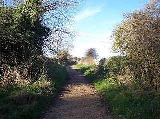
The Sabrina Way is a waymarked long-distance footpath and bridleway in England.

Rushbury is a village and civil parish in Shropshire, roughly five miles from Church Stretton and eight miles from Much Wenlock.
For the children's novel by Sheena Porter, please see Nordy Bank (novel).

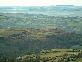
Bury Ditches is a British Iron Age hill fort between Clun and Bishop's Castle in the Shropshire Hills of central England.

Sir William Vaughan was a cavalry officer in the armies of Charles I of England. Initially serving in Ireland during the Confederate Wars, the outbreak of the First English Civil War led to him being sent to England in 1644, at the head of an Anglo-Irish cavalry regiment, to reinforce the Royalist army.
The Geopark Way is a waymarked long-distance trail located within the counties of Shropshire, Worcestershire, Herefordshire and Gloucestershire, England. It runs 109 miles (175 km) from Bridgnorth to Gloucester.
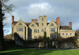
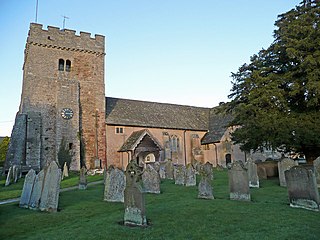
Shipton Hall is a large Elizabethan country house in the village of Shipton, Shropshire, England, which lies in the Corvedale valley some 7 miles south-west of Much Wenlock. It is a Grade I listed building.
