
Hares and jackrabbits are mammals belonging to the genus Lepus. They are herbivores, and live solitarily or in pairs. They nest in slight depressions called forms, and their young are able to fend for themselves shortly after birth. The genus includes the largest lagomorphs. Most are fast runners with long, powerful hind legs, and large ears to dissipate body heat. Hare species are native to Africa, Eurasia and North America. A hare less than one year old is called a "leveret". A group of hares is called a "husk", a "down", or a "drove".

The lagomorphs are the members of the taxonomic order Lagomorpha, of which there are two living families: the Leporidae and the Ochotonidae (pikas). There are 110 recent species of lagomorph of which 109 are extant, including 10 genera of rabbits, 1 genus of hare and 1 genus of pika. The name of the order is derived from the Ancient Greek lagos + morphē.

U.S. Route 66 or U.S. Highway 66 was one of the original highways in the United States Numbered Highway System. It was established on November 11, 1926, with road signs erected the following year. The highway, which became one of the most famous roads in the United States, ran from Chicago, Illinois, through Missouri, Kansas, Oklahoma, Texas, New Mexico, and Arizona before terminating in Santa Monica in Los Angeles County, California, covering a total of 2,448 miles (3,940 km).

Seligman is a census-designated place (CDP) on the northern border of Yavapai County, in northwestern Arizona, United States. The population was 456 at the 2020 census. It is one of the stops on historic U.S. Route 66.

The jackalope is a mythical animal of North American folklore described as a jackrabbit with antelope horns. The word jackalope is a portmanteau of jackrabbit and antelope. Many jackalope taxidermy mounts, including the original, are made with deer antlers.

U.S. Route 66 also known as the Will Rogers Highway, was a major United States Numbered Highway in the state of Arizona from November 11, 1926, to June 26, 1985. US 66 covered a total of 385.20 miles (619.92 km) through Arizona. The highway ran from west to east, starting in Needles, California, through Kingman and Seligman to the New Mexico state line. Nationally, US 66 ran from Santa Monica, California, to Chicago, Illinois. In its height of popularity, US 66 was one of the most popular highways in the state of Arizona, sometimes carrying over one million cars a year.
The historic U.S. Route 66 ran east–west across the central part of the state of New Mexico, along the path now taken by Interstate 40 (I-40). However, until 1937, it took a longer route via Los Lunas, Albuquerque, and Santa Fe, now roughly New Mexico State Road 6 (NM 6), I-25, and US 84. Large portions of the old road parallel to I-40 have been designated NM 117, NM 118, NM 122, NM 124, NM 333, three separate loops of I-40 Business, and state-maintained frontage roads.
A jackrabbit, or hare, is a mammal belonging to the genus Lepus.

The mountain cottontail or Nuttall's cottontail is a species of mammal in the family Leporidae. It is found in Canada and the United States.

Yucca is an unincorporated community and census-designated place (CDP) in Mohave County, Arizona, United States. As of the 2020 census it had a population of 96, down from 126 at the 2010 census.

The black-tailed jackrabbit, also known as the American desert hare, is a common hare of the western United States and Mexico, where it is found at elevations from sea level up to 10,000 ft (3,000 m). Reaching a length around 2 ft (61 cm), and a weight from 3 to 6 lb, the black-tailed jackrabbit is one of the largest North American hares. Black-tailed jackrabbits occupy mixed shrub-grassland terrains. Their breeding depends on the location; it typically peaks in spring, but may continue all year round in warm climates. Young are born fully furred with eyes open; they are well camouflaged and are mobile within minutes of birth, thus females do not protect or even stay with the young except during nursing. The average litter size is around four, but may be as low as two and as high as seven in warm regions.

John Randall Nelson is an American painter and sculptor based in Phoenix, Arizona.

Bowlin Travel Centers, Inc. is a New Mexico–based family owned company that operates a chain of roadside convenience stores and travel centers found on highways in the American southwest. The stores are located primarily in the U.S. states of Arizona and New Mexico; their corporate headquarters are located in Albuquerque. The company's Chief Executive Officer is Michael L. Bowlin.
The 1954 South Dakota State Jackrabbits football team was an American football team that represented South Dakota State University in the North Central Conference (NCC) during the 1954 college football season. In its eighth season under head coach Ralph Ginn, the team compiled a 7–2 record, tied for the conference championship, and outscored opponents by a total of 338 to 151.
The 1952 South Dakota State Jackrabbits football team was an American football team that represented South Dakota State University in the North Central Conference during the 1952 college football season. In its sixth season under head coach Ralph Ginn, the team compiled a 4–4–1 record and outscored opponents by a total of 287 to 230.
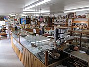 The interior of the Jack Rabbit Trading Post
 The eponymous large Jack Rabbit
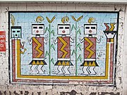 A mural on a wall at the trading post
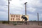 The famous "HERE IT IS" rabbit covered sign for the Jack Rabbit Trading Post


