Jack Straw's Lane

Last updated

View west down Jack Straw's Lane. Jack Straw's Lane, Oxford.JPG
View west down Jack Straw's Lane.
View of St Michael & All Angels Parish Church from the southwest, on the corner of Jack Staw's Lane with Marston Road. NewMarston StMichael&AllAngels southwest.JPG
View of St Michael & All Angels Parish Church from the southwest, on the corner of Jack Staw's Lane with Marston Road.
Alternative view of St Michael & All Angels Parish Church from the southeast, on Jack Staw's Lane. NewMarston StMichael&AllAngels southeast.JPG
Alternative view of St Michael & All Angels Parish Church from the southeast, on Jack Staw's Lane.
View of the former Milham Ford School building from Jack Straw's Lane, now used by Oxford Brookes University. Marston Road site, Oxford Brookes University.JPG
View of the former Milham Ford School building from Jack Straw's Lane, now used by Oxford Brookes University.

Jack Straw's Lane is a residential road in Oxford, England. [1] It runs between the north end of Pullens Lane on Headington Hill and Marston Road.

Contents

History

The land east of the Marston Road was part of Headington until the 20th century and was thus in the parish of St Andrew's Church. [2] Under the Headington Enclosure Award of 1804–5, the Lord of the Manor of Headington acquired a 280-acre (1.1 km2) plot that included the whole of Jack Straw's Lane. Jack Straw's Farmhouse, also known as Jack Straw's Castle, lay to the north of the lane, along with a brickworks between the farmhouse and the Marston Road. Until the 20th century, the lane had no name. It was originally a track at the end of Pullens Lane that led to the farmhouse. The name of the road dates from at least 1932 and the road was official adopted in 1954. [1]

In 1898, Cowley House (now a children's nursery) together with Cowley Cottage were built on the south side of the lane. Subsequently, other large houses were built on the lane, with a rural feel but close to central Oxford.

Name

Jack Straw is traditionally supposed to have been a farmer who lived on Headington Hill. [3] Although many highwaymen were active in this area, no leader was ever found. However, when Jack Straw died, the cellar underneath his farm kitchen contained expensive goods stolen from merchants and travellers. [2] The name has nothing to do with the Labour politician and former Justice Secretary Jack Straw. The name dates from at least 1932, although it was not officially adopted until 1954. [3]

Milham Ford School

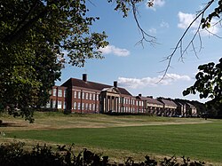
In the 1930s, Milham Ford School was built on a 16-acre (65,000 m2) site between Jack Straw's Lane and Harberton Mead. [2] It opened in 1938, became a girls' grammar school in 1944, and a girls' comprehensive school in 1974. The school was closed in 2003 and was sold. In 2004, the School of Health Care and Social Science of Oxford Brookes University started to use the building. [4] This became the Faculty of Health and Life Sciences. [5]

Today

Jack Straw's Lane is a residential area with houses on large plots and with high prices. [6] The lane is lined with large mature trees. The University of Oxford runs a day nursery, the Jack Straws Lane Nursery, located at 32b Jack Straw's Lane. [7]

Related Research Articles

Marston, Oxford Human settlement in England

Marston is a village in the civil parish of Old Marston about 2 miles (3 km) northeast of the centre of Oxford, England. It was absorbed within the city boundaries in 1991. It is commonly called Old Marston to distinguish it from the suburb of New Marston that developed between St. Clement's and the village in the 19th and 20th centuries. The A40 Northern Bypass, part of the Oxford Ring Road forms a long north-west boundary of the village and parish and a limb, namely a distributary, of the Cherwell forms the western boundary.

Oxford Brookes University University in Oxford

Oxford Brookes University is a public university in Oxford, England. It is a new university, having received university status through the Further and Higher Education Act 1992. It can trace its origins to 1865, when it was founded as the Oxford School of Art. The university was named after its first principal, John Henry Brookes, who played a major role in the development of the institution.

Oxford East (UK Parliament constituency) Parliamentary constituency in the United Kingdom

Oxford East is a constituency represented in the House of Commons of the UK Parliament by Anneliese Dodds of the Labour Party, who also serves as party chair.

Headington Suburb of Oxford, England

Headington is an eastern suburb of Oxford, England. It is at the top of Headington Hill overlooking the city in the Thames valley below, and bordering Marston to the north-west, Cowley to the south, and Barton and Risinghurst to the east. The life of the large residential area is centred upon London Road, the main road between London and Oxford.

New Marston Human settlement in England

New Marston is a suburb about 1.25 miles (2 km) northeast of the centre of Oxford, England.

St Clements, Oxford Human settlement in England

St Clement's is a district in Oxford, England, on the east bank of the River Cherwell. "St Clement's" is usually taken to describe a small triangular area from The Plain bounded by the Cherwell in the West, Cowley Road in the East. to the foot of Headington Hill in the South. It also refers to the ecclesiastical parish of St Clement's which includes some neighbouring areas and is used in the names of local City and County electoral districts.

<span class="mw-page-title-main">Marston Road</span> Road in east Oxford, England

Marston Road is a road in the east of Oxford, England. It links London Place, the junction of St Clements, the foot of Headington Hill, and Morrell Avenue by South Park to the south with the suburb of New Marston to the north. A mini-roundabout has been replaced by traffic lights and connects with Cherwell Drive and Headley Way at the northern end. To the north is the suburb of Northway. The road is designated the B4150 but this is not shown on signs.

<span class="mw-page-title-main">Headington Road</span> Road in the east of Oxford, Engand

Headington Road is an arterial road in the east of Oxford, England. The road connects the junction of St Clements and Marston Road with the suburb of Headington, up Headington Hill. When it reaches the Headley Way junction, it becomes London Road, as the Boundary Brook runs under the road at this point.

<span class="mw-page-title-main">Marston Ferry Road</span> Road in North Oxford, England

Marston Ferry Road is a link road in north Oxford, England. It is named after the ferry that used to cross the River Cherwell at the village of Marston from at least 1279.

Cotuit Hall

Cotuit Hall is part of the EF International Academy's campus in Oxford, England. Until 2011 it was one of the halls of residence at Oxford Brookes University.

Plater College was an adult education establishment which was based in Oxford, England.

Harry Wilkinson Moore

Harry Wilkinson Moore, FRIBA (1850–1915) was a Victorian and Edwardian architect. He was the son of Arthur Moore (1814–1873) and Mary Wilkinson (1821–1904), and a nephew of the architects George Wilkinson and William Wilkinson.

<span class="mw-page-title-main">Pullens Lane</span> Road in Headington, east Oxford, England

Pullens Lane is in Headington, east Oxford, England. It is located at the top of Headington Hill, leading north off Headington Road to Jack Straw's Lane and Harberton Mead. The cul-de-sac Pullens Field leads off west from Pullens Lane.

The Vines, Oxford

The Vines is on Pullens Lane, Headington, a suburb in east Oxford, England. It was the first house to be built on the west side of the lane, on land that was originally owned by the Morrell family, local brewers. The house is built of red brick with stone dressings.

Milham Ford School Community school in Oxford, United Kingdom

Milham Ford School was a girls' secondary school in Oxford, England, located in the suburb of New Marston on Marston Road. It was founded in East Oxford in the 1880s and closed in 2003.

Headington Hill Park

Headington Hill Park is a park on Headington Hill in the east of Oxford, England.

<span class="mw-page-title-main">Morrell Avenue</span> Road in Headington, East Oxford, England

Morrell Avenue is a residential tree-lined road in Headington, east Oxford, England.

Dorset House was a large house in Headington, Oxford, England.

References

  1. 1 2 Hibbert, Christopher; Hibbert, Edward (1988). "Jack Straw's Lane". The Encyclopaedia of Oxford. Macmillan. p. 197. ISBN   978-0-333-39917-0 . Retrieved 20 July 2011.
  2. 1 2 3 "Jack Straw's Lane". Stephanie Jenkins. Retrieved 29 January 2020.
  3. 1 2 Symonds, Ann Spokes; Morgan, Nigel (2010). "Jack Straw's Lane". The Origins of Oxford Street Names. Robert Boyd Publications. pp. 50, 132. ISBN   978 1 899536 99 3.
  4. "Marston Road site". Oxford Brookes University. Archived from the original on 6 October 2008. Retrieved 21 October 2012.
  5. "Marston Road site". Faculty of Health and Life Sciences, Oxford Brookes University. Retrieved 21 October 2012.
  6. House prices, Jack Straw's Lane, Oxford OX3.
  7. "Jack Straws Lane Nursery". UK: University of Oxford . Retrieved 30 August 2012.

Coordinates: 51°45′47″N1°13′51″W / 51.7631°N 1.2309°W / 51.7631; -1.2309