Jadopur Jādopur | |
|---|---|
Village | |
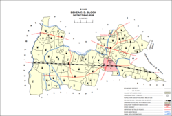 Map of Jadopur (#186) in Behea block | |
 Jadopur Location in Bihar, India  Jadopur Jadopur (India) | |
| Coordinates: 25°32′13″N84°23′16″E / 25.53688°N 84.38769°E [1] | |
| Country | India |
| State | Bihar |
| District | Bhojpur |
| Area | |
• Total | 0.278 km2 (0.107 sq mi) |
| Elevation | 71 m (233 ft) |
| Population (2011) | |
• Total | 2,923 [2] |
| Languages | |
| • Official | Bhojpuri, Hindi |
| Time zone | UTC+5:30 (IST) |
Jadopur is a village in the south-central part of Bihiya block of Bhojpur district, Bihar, India. As of 2011, its population was 2,923, in 417 households. [2]