
Tun Hussein bin Dato' Onn was a Malaysian politician who served as the third prime minister of Malaysia from the death of his predecessor Abdul Razak Hussein in January 1976 to his retirement in July 1981. Moreover, he was the Member of Parliament (MP) for Sri Gading from 1974 to 1981, representing Barisan Nasional (BN) and United Malays National Organisation (UMNO). He was granted the soubriquet Father of Unity.

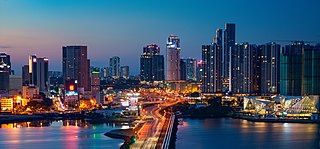
Johor Bahru, colloquially referred to as JB, is the capital city of the state of Johor, Malaysia. It is located along the Straits of Johor, at the southern end of Peninsular Malaysia. The city has a population of 1,711,191 people within an area of 220 km2. Johor Bahru is adjacent to the city of Iskandar Puteri and Pasir Gudang, together with their surrounding areas anchoring Malaysia's second largest urban agglomeration, Iskandar Malaysia, with a population of 2,500,000.
Century Garden is one of the earliest housing development in Johor Bahru, Johor, Malaysia. The housing ranges from expensive bungalow houses built at the top of the valley to older, more modest single-storey terrace houses built in the 1960s. It was developed by a visionary and prominent Johor Bahru businessman, Yap Siew Cheng (1918–1970). Ambitious and daring at that time because its location was considered quite far out of Johor Bahru town and surrounded by rubber estates.

Johor Bahru Inner Ring Road, (JBIRR) or Jalan Lingkaran Dalam, Federal Route 188, is a multi-lane federal ring road highway that circles the Johor Bahru Central District in Johor, Malaysia. The 4.6-kilometre (2.9 mi) highway was the most expensive road infrastructure project per kilometre of its time in the country.

Masai is an area in Pasir Gudang, Johor Bahru District, Johor, Malaysia, and is the oldest neighbourhood of Johor Bahru town. It is located 25 kilometres from the Johor Bahru city centre. Masai is located on route J10 which leads to Kong Kong, a fishing village along Johor River. The main access roads to Masai are Jalan Masai Lama (J10) and Pasir Gudang Highway.

Kulai is a town and the capital of Kulai District, Johor, Malaysia. It is administered by the Kulai Municipal Council (MPKu), which was earlier known as the Kulai District Council.

Malaysian Federal Roads System, is the main national road network in Malaysia. All Federal Roads in Malaysia are under the purview of the Ministry of Works (MOW). According to the Ministerial Functions Act 1969, the MOW is responsible to plan, build and maintain all Federal Roads gazetted under the Federal Roads Act 1959. However, most of the Federal roads' projects were built and maintained by the Malaysian Public Works Department (JKR), which is also one of the implementing agencies under the MOW.

Pasir Gudang Highway, also known as Federal Route 17, is a highway in Johor Bahru District, Johor, Malaysia that connects Tampoi North in the west to Pasir Gudang and Tanjung Langsat in the east. Pasir Gudang Highway is a four-laned highway, unlike the wider Skudai Highway which has six lanes. Many cargo trucks travel along the highway daily. Pasir Gudang Highway became the backbone of the road system linking Johor Bahru to Pasir Gudang before being surpassed by the Senai–Desaru Expressway, SDE 22, and the Johor Bahru East Coast Highway 35.
Johor Bahru–Kota Tinggi Highway, Federal Route 3, also known as Tebrau Highway and Jalan Kota Tinggi is a highway that encompasses Federal Route 3 in Johor Bahru, Malaysia. Part of Asian Highway Route AH18, the highway stretches from its southern end at Jalan Wong Ah Fook and Jalan Tun Abdul Razak in the metropolitan area of Johor Bahru to the northern end at the underpass flyover with North–South Expressway Southern Route and Johor Bahru Eastern Dispersal Link Expressway around Pandan. The stretch of Tebrau Highway after this continues as Jalan Pandan and Jalan Kota Tinggi respectively, beyond Pandan. The highway became the backbone of the Johor Bahru road system linking Pandan to city centre, and to the Johor–Singapore Causeway, before being surpassed by the Johor Bahru Eastern Dispersal Link Expressway in 2012.
Senai Airport Highway or Jalan Lapangan Terbang Senai, Federal Route 16 is a major highway in Kulai District, Johor, Malaysia that connects Senai International Airport to Senai, which from there connected to Johor Bahru via Federal Route 1 Skudai Highway.
Federal Route 92, also known as Pengerang Highway, is a federal highway that runs from Kota Tinggi to Sungai Rengit in Johor, Malaysia. The 66.8 km (41.5 mi) highway is also a main route to Desaru beach. Federal Route 92 became the backbone of the road system linking the southeastern Johor before being surpassed by the Senai–Desaru Expressway E22.
Federal Route 50, or Jalan Batu Pahat–Kluang–Mersing, is a main federal road in Johor, Malaysia. The road connects Batu Pahat in the west to Jemaluang in the east. It is also a main route to North-South Expressway Southern Route via Ayer Hitam Interchange.

Majidee Malay Village is a Malay village located in the city of Johor Bahru, Johor, Malaysia. Its population is around 30,000.
Jalan Tampoi, Federal Route 3374, is a dual carriageway industrial federal roads in Johor Bahru, Johor, Malaysia. Before Pasir Gudang Highway was built, Jalan Tampoi became the main road to Pasir Gudang together with Jalan Masai Lama.

The Kulai District is a district in the state of Johor, Malaysia. Its district capital is Kulai Town. It covers Kulai Town, Ayer Bemban, Bandar Putra Kulai, Bukit Batu, Indahpura, Bandar Baru Kangkar Pulai, Kelapa Sawit, Saleng, Sedenak, Seelong, Senai, and Sengkang. Kulai is also within Iskandar Malaysia economic zone.
Iskandar Malaysia, formerly known as Iskandar Development Region and South Johor Economic Region (SJER), is the main southern development corridor in Johor, Malaysia. It was established on 8 November 2006. Iskandar Malaysia, which is formed by major cities such as Johor Bahru, Iskandar Puteri, Pasir Gudang, together with their surrounding areas, is Malaysia's second largest urban agglomeration with a population of 2,500,000, after Greater Kuala Lumpur.

Johor, also spelled as Johore, is a state of Malaysia in the south of the Malay Peninsula. Johor has land borders with the Malaysian states of Pahang to the north and Malacca and Negeri Sembilan to the northwest. Johor shares maritime borders with Singapore to the south and Indonesia to both the west and east. Johor Bahru is the capital city and the economic centre of the state, Kota Iskandar is the seat of the state government, and Muar serves as the royal town of the state. The old state capital is Johor Lama. As of 2020, the state's population is 4.01 million, making it the second most populated state in Malaysia. Johor has highly diverse tropical rainforests and an equatorial climate. The state's mountain ranges form part of the Titiwangsa Range, which is part of the larger Tenasserim Range connected to Thailand and Myanmar, with Mount Ophir being the highest point in Johor. While its state capital, Johor Bahru, which is located within Iskandar Malaysia development corridor, is one of the most densely populated and fastest-growing urbans in Malaysia.
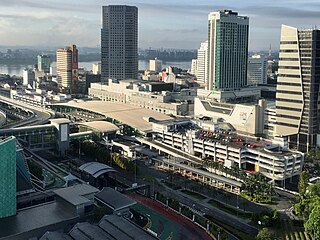
Johor Bahru Sentral is an integrated transport hub in Bukit Chagar, Johor Bahru, Johor, Malaysia.
The Iskandar Coastal Highway (ICH) or the stretch of road that includes Lebuhraya Sultan Iskandar, Persiaran Sultan Abu Bakar and Persiaran Sultan Ismail is a highway in Johor Bahru District, Johor, Malaysia. The 23 km (14 mi) highway connects Iskandar Puteri in the west to Johor Bahru in the east. It is a toll free highway and part of the Iskandar Malaysia project. The Iskandar Coastal Highway is the fifth east–west-oriented expressway in the Iskandar Malaysia area after the Pasir Gudang Highway, the Pontian–Johor Bahru Link of the Second Link Expressway, the Senai–Desaru Expressway and the Johor Bahru East Coast Highway.

Segamat is a town located in the Segamat District, Johor, Malaysia. It is 95 km travel distance via North–South Expressway from Johor Bahru to Yong Peng, and another 77 km from Federal Route 1.