
Yo-Yo Ma is an American cellist. Born in Paris to Chinese parents and educated in New York City, Ma was a child prodigy, performing from the age of four and a half. He graduated from The Juilliard School and Harvard University, and has performed as a soloist with orchestras around the world. He has recorded more than 90 albums and received 18 Grammy Awards.

ISO 3166-1 alpha-2 codes are two-letter country codes defined in ISO 3166-1, part of the ISO 3166 standard published by the International Organization for Standardization (ISO), to represent countries, dependent territories, and special areas of geographical interest. They are the most widely used of the country codes published by ISO, and are used most prominently for the Internet's country code top-level domains. They are also used as country identifiers extending the postal code when appropriate within the international postal system for paper mail, and has replaced the previous one consisting one-letter codes. They were first included as part of the ISO 3166 standard in its first edition in 1974.

Yau Tsim Mong District is one of 18 districts of Hong Kong, located on the western part of Kowloon Peninsula. It is the core urban area of Kowloon. The district has the second highest population density of all districts, at 49,115/km². The 2016 By-Census recorded the total population of Yau Tsim Mong District at 342,970.

Yau Ma Tei is an area in the Yau Tsim Mong District in the south of the Kowloon Peninsula in Hong Kong.

Ma'anshan, also colloquially written as Maanshan, is a prefecture-level city in the eastern part of Anhui province in Eastern China. An industrial city stretching across the Yangtze River, Ma'anshan borders Hefei to the west, Wuhu to the southwest, and Nanjing to the east. It is a satellite city of the Nanjing metropolitan area and is also a city in the Yangtze River Delta Economic Zone.
Interstate 495 (I-495) is an auxiliary route of I-95 in the U.S. state of Massachusetts, maintained by the Massachusetts Department of Transportation (MassDOT). Spanning 120.74 miles (194.31 km), it is the second-longest auxiliary route in the Interstate Highway System, ranking behind I-476 in Pennsylvania by a difference of roughly 11 miles (18 km).

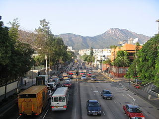
Nathan Road is the main thoroughfare in Kowloon, Hong Kong, aligned south–north from Tsim Sha Tsui to Sham Shui Po. It is lined with shops and restaurants and throngs with visitors, and was known in the post–World War II years as the Golden Mile, a name that is now rarely used. It starts on the southern part of Kowloon at its junction with Salisbury Road, a few metres north of Victoria Harbour, and ends at its intersection with Boundary Street in the north. Portions of the Kwun Tong and Tsuen Wan lines run underneath Nathan Road. The total length of Nathan Road is about 3.6 kilometres (2.2 mi).

Ho Man Tin is an underground MTR rapid transit station on the Kwun Tong line. Located beneath Valley Road in Lo Lung Hang, it will become an interchange station for the Tuen Ma line as part of the Sha Tin to Central Link project, which is under construction. The station's lower platforms opened on 23 October 2016 along with Whampoa station as part of the Kwun Tong line extension, but the upper platforms will remain closed until the completion of the Tuen Ma line.

To Kwa Wan is a bay and an area of the eastern shore of Kowloon peninsula. The area is part of urban Hong Kong, and is situated between Hok Yuen, Hung Hom, Ma Tau Wai and Ma Tau Kok. Administratively, the area belongs to the Kowloon City District of Kowloon.

Ma Tau Kok is a place north of To Kwa Wan, south-east of modern day Ma Tau Chung and south-west of the former Kai Tak Airport in Hong Kong. It was a cape in Kowloon Bay in Victoria Harbour and opposite to the Sacred Hill and the mouth of Ma Tau Chung. Ma Tau Kok is a mixed industrial and residential area.

Ma Tau Chung is an area in Kowloon, Hong Kong, west of Ma Tau Kok and east of Ma Tau Wai. It was named after a creek which originated in Quarry Hill emptying into Kowloon Bay. The village of Ma Tau Chung stood on its eastern bank near the river mouth next to the Sacred Hill.
Waterloo Road is one of the principal north-south thoroughfares of Kowloon, Hong Kong. It stretches from Yau Ma Tei to Kowloon Tong.

Public Square Street is a street in Yau Ma Tei, Kowloon, Hong Kong.

Muhammad Ali Jinnah Road, frequently abbreviated as MA Jinnah Road, is a major thoroughfare in central Karachi, Pakistan. The road was originally named Bandar Road, owing to the fact that it linked the city to the Port of Karachi, but was later renamed in honour of Pakistan's founder, Muhammad Ali Jinnah. MA Jinnah Road stretches 6.1 kilometres from Jinnah Bridge in the south, near the Port of Karachi, to Gurumandir Chowk, north of Mazar-e-Quaid. It is one of the city's oldest roads, and passes through much of the colonial era historic core of Karachi, with numerous landmarks along its route.

Sung Wong Toi is an underground MTR rapid transit station currently under construction in Hong Kong on the East West Corridor, located in Ma Tau Chung in Kowloon City District. The station will serve Kowloon City and Ma Tau Wai. The station is being built as part of the Sha Tin to Central Link (SCL), and is scheduled to open along with the rest of phase 2 of the Tuen Ma line. The station is being constructed by a Samsung–Hsin Chong joint venture.

The following is a list of Public housing estates in Ma On Shan, Hong Kong, including Home Ownership Scheme (HOS), Private Sector Participation Scheme (PSPS), Sandwich Class Housing Scheme (SCHS), Flat-for-Sale Scheme (FFSS), and Tenants Purchase Scheme (TPS) estates.

Route 417 is an intercity road in Israel and the West Bank that stretches from the west side of Jerusalem to Ma'ale Adumim and Highway 1 east to the Jordan Valley.

The Road of the Patriarchs or Way of the Patriarchs, is an ancient north south route traversing the land of Israel. The name is used by biblical scholars because of mentions in biblical narratives that it was frequently travelled by Abraham, Isaac and Jacob.

Transoxiana is an ancient name referring to a region and civilization located in lower Central Asia roughly corresponding to modern-day eastern Uzbekistan, Tajikistan, southern Kazakhstan and southern Kyrgyzstan. Geographically, it is the region between the rivers Amu Darya to its south and the Syr Darya to its north.

Ma Ma Creek is a rural town and a locality in the Lockyer Valley Region, Queensland, Australia. In the 2016 census, Ma Ma Creek had a population of 149 people.