Related Research Articles

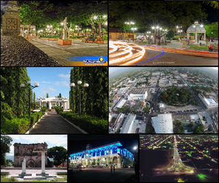
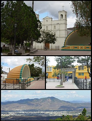
Jalapa is a city in Guatemala. It is the capital of the department of Jalapa; it is also the municipal seat of that department's municipality of Jalapa.
Chiquimula is one of the 22 departments of Guatemala, in Central America. The departmental capital is also called Chiquimula. The department was established by decree in 1871, and forms a part of the southeastern region of Guatemala. Physically, it is mountainous, with a climate that varies between tropical and temperate, depending on the location.
El Progreso is a department in Guatemala. The departmental capital is Guastatoya. The Spanish established themselves in the region by 1551, after the Spanish conquest of Guatemala. El Progreso was declared a department in 1908, but was dissolved in 1920 before being reestablished in 1934. Guastatoya was badly affected by the 1976 Guatemala earthquake.
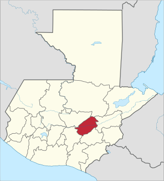
Jalapa is a department of Guatemala, in the south east-of the republic. The capital is the city of Jalapa.

Zacapa is one of the 22 departments of Guatemala. It lies in eastern Guatemala with its capital in the city of Zacapa, approximately 112 kilometers from Guatemala City.

The Motagua River is a 486-kilometre-long (302 mi) river in Guatemala. It rises in the Western Highlands of Guatemala and runs in an easterly direction to the Gulf of Honduras. The Motagua River basin covers an area of 12,670 square kilometres (4,890 sq mi) and is the largest in Guatemala.
Estadio Las Flores is a football stadium located in Jalapa, Guatemala. It is home to first division club Deportivo Jalapa ; its capacity is 15,000.
San Cristóbal Acasaguastlán is a town in the El Progreso department of Guatemala. San Cristóbal Acasaguastlán is located on the northern bank of the Motagua River at an altitude of 250 m. It had a population of 6,129 people at the 2002 census, and covers a territory of 124 square kilometres (48 sq mi). San Cristóbal Acasaguastlán borders on San Agustín Acasaguastlán to the northwest, Usumatlán to the east, and El Jicaro to the south. It is located on the inter-ocean highway (CA-9), 101 km from Guatemala City.
San Pedro Pinula is a town and municipality in the Jalapa department of Guatemala. There is a cathedral in the town.
Monjas is a town, with a population of 13,541, and a municipality in the Jalapa department of Guatemala, approximately 80 kilometres (50 mi) from Guatemala City, Guatemala.
San Luis Jilotepeque is a town, with a population of 11,675, and a municipality in the Jalapa department of Guatemala. The municipality has a population of 24,679, and cover an area of 209 km2.

San Manuel Chaparrón is a municipality in the Jalapa department of Guatemala.
The Diocese of Jalapa is a Latin Church ecclesiastical territory or diocese of the Catholic Church in southeastern Guatemala. It is a suffragan diocese in the ecclesiastical province of the metropolitan Archdiocese of Santiago de Guatemala.

The Motagua Fault is a major, active left lateral-moving transform fault which cuts across Guatemala. It forms part of the tectonic boundary between the North American Plate and the Caribbean Plate. It is considered the onshore continuation of the Swan Islands Transform Fault and Cayman trench, which run under the Caribbean Sea. Its western end appears not to continue further than its surface trace, where it is covered by Cenozoic volcanics.
The Río Grande de Zacapa is a river in Guatemala. From its sources in the southern mountain range in the departments of Zacapa and Chiquimula, the river flows northwards until it reaches the Motagua River at 15.032048°N 89.555826°W. The Río Grande de Zacapa is 87 kilometres (54 mi) long and its river basin covers an area of 2,462 km².

The Lempa River is a 422-kilometre-long (262 mi) river in Central America.
The Chixoy-Polochic Fault, also known as Cuilco-Chixoy-Polochic Fault, is a major fault zone in Guatemala and southeast Mexico. It runs in a light arc from the east coast of Guatemala to Chiapas, following the deep valleys of the Polochic River, Chixoy River and Cuilco River.

Tulumaje is a small village situated along the Rio Motagua, the largest river of Guatemala. This village is characterized by a predominantly hot and humid climate; droughts are rare, because of the abundant sources of water such as the Motagua river and Las Vegas river, both surrounding the place. The area is largely forested, bringing to the region frequent rainy days.

Guaytán is an archaeological site of the Maya civilization in the municipality of San Agustín Acasaguastlán, in the department of El Progreso, in Guatemala. It is the most important pre-Columbian archaeological site of the middle drainage of the Motagua River.