Jalapa, Jalapa

Last updated
Jalapa
Templo catolico principal de Jalapa. - panoramio.jpg
Catholic church in Jalapa
Flag of Jalapa Department, Guatemala.svg
Coat of arms of Jalapa Department.svg
Guatemala location map.svg
Red pog.svg
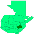
Jalapa
Location in Guatemala
Coordinates: 14°38′N89°59′W / 14.633°N 89.983°W / 14.633; -89.983
Country Flag of Guatemala.svg Guatemala
Department Flag of Jalapa Department, Guatemala.svg Jalapa
Population
 (2018)
159,840 [1]
Climate Aw

Jalapa is a city in Guatemala. It is the capital of the department of Jalapa; it is also the municipal seat of that department's municipality of Jalapa.

Contents

By the shortest route, via Atlantic Highway, Jalapa is around 97 kilometres (60 mi) from Guatemala City.

Population

As of 1850, the population of Jalapa was approximately 3,500. [2] As of the 2018 census, the town's population reached 159,840.[ citation needed ]

Religion

Its cathedral Nuestra Señora de la Expectación is the episcopal see of the Roman Catholic Diocese of Jalapa (Guatemala).

Climate

The city of Jalapa was built in a valley, surrounded by the Jumay volcano and the mountains of Alcoba and Arluta and the Jalapa Mountains. For this reason and its altitude, 1,362 meters above sea level, the weather is mild temperate.[ citation needed ]

Economy

The local economy is based on agricultural and livestock products. The department of Jalapa produces corn and beans which are the main diet of Guatemalans, but also produces fruits such as peaches, apples, blackberries, bananas, avocados and vegetables such as cabbage, lettuce, broccoli and cauliflower, most of which are exported to El Salvador. Jalapa also produces dairy products and is famous for its cheese, especially queso seco ("dry cheese", a drier version of queso fresco) and mantequilla de costal ("sack butter"), which is produced mainly in Monjas, San Manuel Chaparrón, San Carlos Alzatate and Jalapa.[ citation needed ]

Related Research Articles

<span class="mw-page-title-main">Quetzaltenango</span> City in Guatemala

Quetzaltenango is both the seat of the namesake Department and municipality, in Guatemala. The city is located in a mountain valley at an elevation of 2,330 meters above sea level at its lowest part. It may reach above 2,400 m (7,900 ft) within the city.

<span class="mw-page-title-main">Sacatepéquez Department</span> Department of Guatemala

Sacatepéquez is one of the 22 departments of Guatemala. The name comes from Sacatepéquez, a city from November 21, 1542, until July 29, 1773, when it was destroyed by the 1773 Guatemalan Earthquake. Sacatepéquez means grasshill in the Nahuatl language. The capital of Sacatepéquez is Antigua Guatemala. Other important cities include Ciudad Vieja and San Lucas Sacatepéquez, which also hosts a marketplace and is a culinary attraction. The Chajoma were a group of indigenous people who were Kaqchikel speaking Indians identified Mixco Viejo as their capital, and spread throughout the Sacatepequez Department until their capital was moved to Ciudad Vieja, in Antigua.

<span class="mw-page-title-main">Choluteca Department</span> Department in Honduras

Choluteca is one of the 18 departments (departamentos) into which Honduras is divided. The departmental capital is the city of Choluteca. The Choluteca River runs through the department.

<span class="mw-page-title-main">Chiquimula Department</span> Department of Guatemala

Chiquimula is one of the 22 departments of Guatemala, in Central America. The departmental capital is also called Chiquimula. The department was established by decree in 1871, and forms a part of the southeastern region of Guatemala. Physically, it is mountainous, with a climate that varies between tropical and temperate, depending on the location.

<span class="mw-page-title-main">Jutiapa Department</span> Department of Guatemala

Jutiapa Department is a department of Guatemala that borders along El Salvador and the Pacific Ocean. The capital is the city of Jutiapa. As of 2018, it has a population of 488,395. The department is divided into seventeen municipalities. Jutiapa is the country's southeasternmost department and officially the only department with no Mayan descendants native to the region. The main crops are sorghum, tobacco, onion and corn. The climate is dry. An important attraction is the cattle fair. It is at 405 m above sea level.

<span class="mw-page-title-main">El Progreso Department</span> Department of Guatemala

El Progreso is a department in Guatemala. The departmental capital is Guastatoya. The Spanish established themselves in the region by 1551, after the Spanish conquest of Guatemala. El Progreso was declared a department in 1908, but was dissolved in 1920 before being reestablished in 1934. Guastatoya was badly affected by the 1976 Guatemala earthquake.

<span class="mw-page-title-main">Jalapa Department</span> Department of Guatemala

Jalapa is a department of Guatemala, in the south east-of the republic. The capital is the city of Jalapa.

<span class="mw-page-title-main">Zacapa Department</span> Department of Guatemala

Zacapa is one of the 22 departments of Guatemala. It lies in eastern Guatemala with its capital in the city of Zacapa, approximately 112 kilometers from Guatemala City.

<span class="mw-page-title-main">Ahuachapán</span> Municipality in Ahuachapán Department, El Salvador

Ahuachapán is a city, and municipality, and the capital of the Ahuachapán Department in western El Salvador. The municipality, including the city, covers an area of 244.84 km² and as of 2007 has a population of 110,511 people. Situated near the Guatemalan border, it is the westernmost city in the country and is the center of an agricultural region producing primarily coffee.

<span class="mw-page-title-main">Matagalpa</span> Municipality in Matagalpa Department, Nicaragua

Matagalpa is a city in Nicaragua which is the capital of the department of Matagalpa. The city has a population of 112,697, while the population of the department is 606,643. Matagalpa is Nicaragua's seventh largest city, the largest in the country's interior, and one of the most commercially active outside of Managua. Matagalpa is known as the "Pearl of the North" and "Land of Eternal Spring."

<span class="mw-page-title-main">Ocotepeque</span> Municipality in Honduras

Ocotepeque is a municipality in the Honduran department of Ocotepeque. The town of Nueva Ocotepeque is the municipal seat and the capital of the department.

Gualán is a town and municipality in the Guatemalan department of Zacapa. It is located in the Eastern part of the country about 165 Kilometers from Guatemala City on route CA-9.

<span class="mw-page-title-main">Nahuizalco</span>

Nahuizalco is a municipality in the Sonsonate department of El Salvador. It lies on the "flowers route", 9 km from Sonsonate and 74 km from San Salvador, at 540 m above sea level on the southern part of the Apaneca-Ilamatepec mountain range. Per the population and housing census of 2007, Nahuizalco has 49,081 residents.

<span class="mw-page-title-main">Chalchuapa</span> Place in Santa Ana Department, El Salvador

Chalchuapa is a town and a municipality located in the Santa Ana department of El Salvador. The city of Chalchuapa is in a wide valley at 650 meters above sea level, and watered by the Pampe River.

Quezaltepeque is a municipality, with a population of 28,075 and an area of 239 km2, in the Chiquimula department of Guatemala. The local economy is based on agriculture. Agricultural products include coffee, maize and beans. As of 1993, there was a working telegraph terminal there in the post office.

San Luis Jilotepeque is a town, with a population of 11,675, and a municipality in the Jalapa department of Guatemala. The municipality has a population of 24,679, and cover an area of 209 km2.

Asunción Mita is a town, with a population of 20,936 (2018), and a municipality in the Jutiapa department of Guatemala.

Agua Caliente is a municipality in the Chalatenango department of El Salvador.

<span class="mw-page-title-main">Pamplona, Norte de Santander</span> Municipality in North of Santander, Colombia

Pamplona is a municipality and city in Norte de Santander, Colombia. It is the fifth most populated city and the sixth most populated municipality in the department.

<span class="mw-page-title-main">Lempa River</span> River that flows through Guatemala, El Salvador and Honduras

The Lempa River is a 422-kilometre-long (262 mi) river in Central America.

References

  1. Citypopulation.de Population of the major cities in Guatemala
  2. Baily, John (1850). Central America; Describing Each of the States of Guatemala, Honduras, Salvador, Nicaragua, and Costa Rica. London: Trelawney Saunders. p. 88.

14°38′N89°59′W / 14.633°N 89.983°W / 14.633; -89.983