Related Research Articles

Lincoln is the capital city of the U.S. state of Nebraska and the county seat of Lancaster County. The city covers 100.4 square miles (260.035 km2) with a population of 292,657 in 2021. It is Nebraska's second-most populous city and the 73rd-largest in the United States. Lincoln is the economic and cultural anchor of a substantially larger metropolitan area in southeastern Nebraska, the Lincoln Metropolitan and Lincoln-Beatrice Combined Statistical Areas. The statistical area is home to 361,921 people, making it the 104th-largest combined statistical area in the United States.

Lancaster County is a county located in the U.S. state of Nebraska. As of the 2020 United States Census, the population was 322,608, making it the second-most populous county in Nebraska. Its county seat is Lincoln, the state capital. The county was created in 1859.

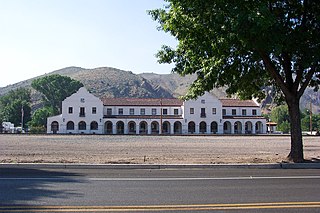
Kearney is the county seat of Buffalo County, Nebraska, United States. The population was 30,787 in the 2010 census. It is home to the University of Nebraska at Kearney. The westward push of the railroad as the Civil War ended gave new birth to the community.

Beatrice is a city in and the county seat of Gage County, Nebraska, United States. Its population was 12,459 at the 2010 census. Beatrice is located approximately 25 miles south of Lincoln on the Big Blue River and is surrounded by agricultural country.

Bennet is a village in Lancaster County, Nebraska, United States. It is part of the Lincoln, Nebraska Metropolitan Statistical Area. The population was 719 at the 2010 census.

Roca is a village in Lancaster County, Nebraska, United States. It is part of the Lincoln, Nebraska Metropolitan Statistical Area. The population was 201 at the 2020 census.
Caliente, formerly known as Culverwell and Calientes, is a city in Lincoln County, Nevada, United States. Its elevation is 4,300 feet (1,300 m). The population was 1,130 at the 2010 census, making it the least populated incorporated city in Nevada. The city's name originated from the nearby hot springs, as "caliente" is the Spanish word meaning "hot".
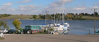
Branched Oak State Recreation Area (SRA) is a Nebraska state recreation area located 2.5 miles north of Malcolm, Nebraska in Lancaster County. The lake is the largest of the Salt Valley Lakes with 1,800 acres (7 km2) of water in a 5,595-acre (23 km2) park.
The Cowboy Trail is a rail trail in northern Nebraska. It is a multi-use recreational trail suitable for bicycling, walking and horseback riding. It occupies an abandoned Chicago and North Western Railway corridor. When complete, the trail will run from Chadron to Norfolk, a length of 321 miles (517 km), making it the longest rails-to-trails conversion in the United States. It is Nebraska's first state recreational trail. The trail runs across the Outback area of Nebraska.
The Midland Pacific Railway was a railroad operating in the Nebraska counties of Lancaster, Nemaha, Otoe, Seward, and York.
The Jamaica North Trail is a 6.5-mile-long (10.5 km) pedestrian and cycling trail running through southwest Lincoln, Nebraska, USA.

The Historic Union Pacific Rail Trail State Park is a recreational trail that follows abandoned railroad lines in Summit County, Utah, United States.
Roach is a ghost town and railroad siding in Clark County, Nevada, United States. It is located along the Union Pacific Railroad, between Jean, Nevada and Nipton, California.

Limon Railroad Depot was a major Union Pacific and Chicago, Rock Island and Pacific Railroad station in Limon, Colorado. It has been on the National Register of Historic Places since 2003. It is included in what is now the Limon Heritage Museum and Railroad Park. It is one of seven still standing Rock Island Line stations in Colorado, and the only one restored.

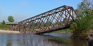
The 1894 Rock Island railroad wreck occurred when a locomotive pulling two passenger cars was derailed on August 9, 1894, in Lincoln, Nebraska, killing eleven people. There were signs that a 400-foot trestle had been purposely damaged, and it was ruled as sabotage. A local man was jailed for second-degree murder, though his guilt remains in doubt. It was one of the worst cases of mass murder in the state of Nebraska.
Wilderness Park is a 1,472-acre (596 ha) mostly-public conservancy located in southwest Lincoln, Nebraska. The park is the largest in Lincoln and is separated into several branches. S 14th St, a north-south street dissects much of the south end of the park.

Lincoln, Nebraska has many neighborhoods, including 45 recognized by Urban Development, City of Lincoln. A list and description of neighborhoods within Lincoln city limits follows.
Saltillo was an unincorporated community in Lancaster County, Nebraska, United States.
The history of Lincoln, Nebraska began with the settlement of the village of Lancaster in 1856. The county of Lancaster was founded in 1859. Prior to settlement from the westward expansion of the United States, Plains Indians, descendants of indigenous peoples who occupied the area for thousands of years lived in and hunted along Salt Creek. Settlers first came to extract salt from the wild salt flats of Salt Creek. Nebraska was granted statehood March 1, 1867. Soon afterwards a commission created by the State was appointed to locate the State Capital on State lands. The village of Lancaster was chosen for the Capital of Nebraska. The village of Lancaster became Lincoln. Lincoln was named after Abraham Lincoln. The first State Capitol was completed in 1868. Lincoln incorporated on April 1, 1869.
Capitol Beach Lake is a 300 acres (120 ha) private lake in west Lincoln, Nebraska. The lake is managed by the Capitol Beach Community Association.
References
- ↑ "GNIS Detail - Jamaica". geonames.usgs.gov. Retrieved 2020-09-01.
- 1 2 3 4 5 "15 more Nebraska ghost towns". JournalStar.com. Retrieved 2020-09-01.
- ↑ "Lincoln Lancaster County Genealogical Society - GHOST TOWNS OF LANCASTER". llcgs.info. Retrieved 2020-09-01.
- 1 2 3 "Plat of Yankee Hill". Library of Congress. Retrieved 2020-09-01.
- ↑ Star, ALGIS J. LAUKAITIS / Lincoln Journal. "New trail takes shape". JournalStar.com. Retrieved 2020-09-01.
- ↑ "Great Plains Trail Network : Trails : Jamaica North Trail". www.gptn.org. Retrieved 2020-09-01.
Coordinates: 40°41′56″N96°41′23″W / 40.6988903°N 96.6897400°W