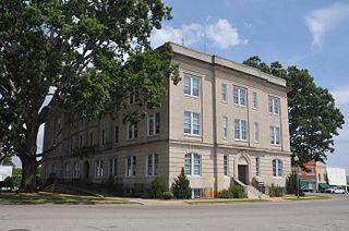
Moore County is a county located in the U.S. state of North Carolina. As of the 2020 census, its population was 99,727. Its county seat is Carthage and its largest community Pinehurst. It is a border county between the Piedmont and the Atlantic Coastal Plain.

Will Rogers World Airport, also known as Will Rogers Airport or simply Will Rogers, is a passenger airport located in Oklahoma City, Oklahoma, United States, about 6 miles (10 km) southwest of the city's downtown area. It is a civil-military airport on 8,081 acres of land. Although the official IATA and ICAO airport codes for Will Rogers World Airport are OKC and KOKC, it is common practice to refer to it as "WRWA" or "Will Rogers".

The Ninety-Nines: International Organization of Women Pilots, also known as The 99s, is an international organization that provides networking, mentoring, and flight scholarship opportunities to recreational and professional female pilots. Founded in 1929, the Ninety-Nines has 153 chapters and 27 regional 'sections' across the globe as of 2022, including a 'virtual' chapter, Ambassador 99s, which meets online for those who are too busy or mobile to be in one region for long.

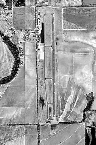
Wichita Dwight D. Eisenhower National Airport is a commercial airport 7 miles (11 km) west of downtown Wichita, Kansas, United States. It is the largest and busiest airport in the state of Kansas. Located south of US-54 in southwest Wichita, it covers 3,248 acres and contains three runways.

Alliance Municipal Airport is in Box Butte County, Nebraska, three miles southeast of the city of Alliance, which owns it. Denver Air Connection offers scheduled passenger flights to Denver, which are subsidized by the Essential Air Service program.

Florence Regional Airport is three miles east of Florence, in Florence County, South Carolina.
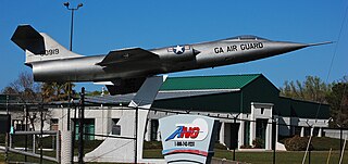
A gate guardian or gate guard is a withdrawn piece of equipment, often an aircraft, armoured vehicle, artillery piece, or locomotive, mounted on a plinth and used as a static display near to and forming a symbolic display of "guarding" the main entrance to a site, especially a military base. Commonly, gate guardians outside airbases are decommissioned examples of aircraft that were once based there, or still are.

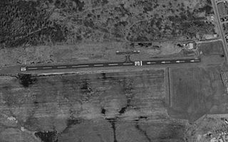
Greenville Downtown Airport is an airport three miles east of Greenville, South Carolina, United States. It is owned by the Greenville Airport Commission and is the busiest general aviation airport in South Carolina.

College Park Airport is a public airport located in the City of College Park, in Prince George's County, Maryland, United States. It is the world's oldest continuously operated airport. The airport is located south of Paint Branch and Lake Artemesia, east of U.S. Route 1 and the College Park Metro/MARC station and west of Kenilworth Avenue.
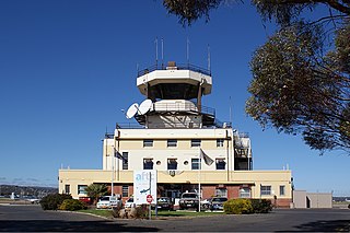
Parafield Airport is on the edge of the residential suburb of Parafield, South Australia, 18 km (11 mi) north of the Adelaide city centre and adjacent to the Mawson Lakes campus of the University of South Australia. It is Adelaide's second airport and the third busiest airport in Australia by aircraft movements. Although owned by the Government of Australia, the airport is leased to and managed independently by Parafield Airport Ltd., a wholly owned subsidiary of Adelaide Airport Limited.

Cincinnati Municipal Airport – Lunken Field is a public airport in Cincinnati, Ohio, three miles (5 km) east of Downtown Cincinnati. It is owned by the city of Cincinnati and serves private aircraft, including the fleets of local corporations. It serves a few commercial flights and is the second-largest airport serving Cincinnati after Cincinnati/Northern Kentucky International Airport, which is the area’s primary airport. It is known as Lunken Airport or Lunken Field, after Eshelby Lunken. It is bounded by US Route 50 to the west, US Route 52 and the Ohio River to the south, the Little Miami River to the east, and Ohio Route 125 to the north. The airport is headquarters and hub for Cincinnati-based public charter airline Ultimate Air Shuttle, serving 5 destinations in the eastern United States with 16 peak daily flights. Lunken is also home to small charter airline Flamingo Air and its aviation school.

Zamperini Field is a public airport three miles (5 km) southwest of downtown Torrance, in Los Angeles County, California, United States.
Grider Field, also known as Pine Bluff Regional Airport, is a municipal airport at Pine Bluff, Arkansas. It was established in 1941 as a U.S. Army Flight Training School operated by the Pine Bluff School of Aviation. After World War II, the city turned it into a commercial airport facility. It is a 850 acre facility consisting of a large terminal and restaurant, FAA weather monitoring equipment, private corporate hangars, fixed-base operators offering fuel and avionics services, a fire station, and aviation museum. It serves as the only ILS-equipped, jet capable airport in southeast Arkansas.

Punta Gorda Airport is a public airport three miles east of Punta Gorda, in Charlotte County, Florida. It is owned by the Charlotte County Airport Authority and was formerly called Charlotte County Airport. The airport has mainly been used for general aviation, but has recently seen more scheduled airline service, with flights offered by Allegiant Air to fifty-one destinations.

Walnut Ridge Regional Airport is a city-owned public-use airport located four nautical miles (7 km) northeast of the central business district of Walnut Ridge, a city in Lawrence County, Arkansas, United States. According to the FAA's National Plan of Integrated Airport Systems for 2009–2013, its FAA airport category is general aviation.

Hezarfen Airfield is a privately owned airport for general aviation in the Çatalca district of Istanbul, Turkey. It is one of a total of five airports in Istanbul along with Istanbul Airport (LTFM), Istanbul Sabiha Gökçen International Airport (LTFJ), Atatürk Airport (LTBA), and Samandıra Army Air Base (LTBX). Hezarfen Airfield is named after Hezârfen Ahmet Çelebi, a legendary Ottoman aviator, who flew across the Bosporus in the 17th century, as told by a contemporary traveler Evliya Çelebi.

James Rogers McConnell flew as an aviator during World War I in the Lafayette Escadrille and authored Flying for France. He was the first of sixty-four University of Virginia students to die in battle during that War.
Michael Airfield is a public airport located on 34 acres just northwest of the central business district of Cicero, New York, United States. The airport is privately owned but open to public flight operations.

Webb Air Force Base, previously named Big Spring Air Force Base, was a United States Air Force facility of the Air Training Command that operated from 1951 to 1977 in West Texas within the current city limits of Big Spring. Webb AFB was a major undergraduate pilot training (UPT) facility for the Air Force, and by 1969, almost 9,000 pilots had been trained at Webb. The last operational wing at Webb AFB was the 78th Flying Training Wing.

Columbia Field, originally Curtiss Field, is a former airfield near Valley Stream within the Town of Hempstead on Long Island, New York. Between 1929 and 1933 it was a public airfield named Curtiss Field after the Curtiss-Wright aircraft corporation that owned it. The public airfield closed after 1933, but aircraft continued to be manufactured there primarily by Columbia Aircraft Corporation, which gave the private airfield its name.
