
Chiricahua is a band of Apache Native Americans.

El Fuerte is a city and El Fuerte Municipality its surrounding municipality in the northwestern Mexican state of Sinaloa. The city population reported in the 2010 census was 12,566 people.

The Chino Mine, also known as the Santa Rita mine, also known as Santa Rita del Cobre, is an open-pit porphyry copper mine located in the town of Santa Rita, New Mexico 15 miles (24 km) east of Silver City. The mine was started as the Chino Copper Company in 1909 by mining engineer John M. Sully and Spencer Penrose, and is currently owned and operated by Freeport-McMoRan Inc. subsidiaries. The area where the mine is located is at an average elevation of 5,699 feet (1,737 m).

The Santa Fe Trail was a 19th-century route through central North America that connected Franklin, Missouri, with Santa Fe, New Mexico. Pioneered in 1821 by William Becknell, who departed from the Boonslick region along the Missouri River, the trail served as a vital commercial highway until 1880, when the railroad arrived in Santa Fe. Santa Fe was near the end of El Camino Real de Tierra Adentro, which carried trade from Mexico City.
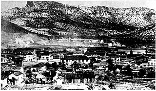
Santa Rita is a ghost town in Grant County in the U.S. state of New Mexico. The site of Chino copper mine, Santa Rita was located fifteen miles east of Silver City.

Mount Wrightson is a 9,456-foot (2,882 m) peak in the Santa Rita Mountains within the Coronado National Forest, in southern Arizona, United States.

The emergence of metallurgy in pre-Columbian Mesoamerica occurred relatively late in the region's history, with distinctive works of metal apparent in West Mexico by roughly AD 800, and perhaps as early as AD 600. Metallurgical techniques likely diffused northward from regions in Central or South America via maritime trade routes; recipients of these metallurgical technologies apparently exploited a wide range of material, including alloys of copper-silver, copper-arsenic, copper-tin and copper-arsenic-tin.

The Camino Real de Tierra Adentro was an historic 2,560-kilometre-long (1,590 mi) trade route between Mexico City and San Juan Pueblo, New Mexico, USA, from 1598 to 1882. It was the northernmost of the four major "royal roads" that linked Mexico City to its major tributaries during and after the Spanish colonial era.

James Kirker (1793–1852) was an Irish-born American privateer, soldier, mercenary, merchant, Mountain man, and scalp hunter. He is best known for his contracts with the Mexican government to kill or capture Apache Indians.
In the American Old West, overland trails was built by pioneers and immigrants throughout the 19th century and especially between 1829 and 1870 as an alternative to sea and railroad transport. These immigrants began to settle much of North America west of the Great Plains as part of the mass overland migrations of the mid-19th century. Settlers migrating from the eastern United States were spurred by various motives, among them religious persecution and economic incentives, to move to destinations in the far west via routes including the Oregon Trail, California Trail, and Mormon Trail. After the end of the Mexican–American War in 1849, vast new American conquests again enticed mass immigration. Legislation like the Donation Land Claim Act and significant events like the California Gold Rush further lured people to travel overland to the west.

Southern Emigrant Trail, also known as the Gila Trail, the Kearny Trail, Southern Trail and the Butterfield Stage Trail, was a major land route for immigration into California from the eastern United States that followed the Santa Fe Trail to New Mexico during the California Gold Rush. Unlike the more northern routes, pioneer wagons could travel year round, mountain passes not being blocked by snows, however it had the disadvantage of summer heat and lack of water in the desert regions through which it passed in New Mexico Territory and the Colorado Desert of California. Subsequently, it was a route of travel and commerce between the eastern United States and California. Many herds of cattle and sheep were driven along this route and it was followed by the San Antonio-San Diego Mail Line in 1857-1858 and then the Butterfield Overland Mail from 1858 - 1861.
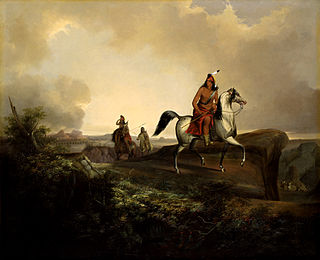
Baishan, Spanish name Cuchillo Negro, was a Tchihende (Mimbres) Apache chieftain, of the Warm Springs Apache Band during the 1830s to 1850s.

The Apache–Mexico Wars, or the Mexican Apache Wars, refer to the conflicts between Spanish or Mexican forces and the Apache peoples. The wars began in the 1600s with the arrival of Spanish colonists in present-day New Mexico. War between the Mexicans and the Apache was especially intense from 1831 into the 1850s. Thereafter, Mexican operations against the Apache coincided with the Apache Wars of the United States, such as during the Victorio Campaign. Mexico continued to operate against hostile Apache bands as late as 1915.
Ojo de Vaca Station, was a Butterfield Overland Mail stagecoach station at Ojo de Vaca, in New Mexico Territory. It was located 14 mi (23 km) northeast of Soldiers Farewell Station and 16 mi (26 km) southwest of Miembre's River Station, later Mowry City. The site is now Cow Springs Ranch located in Luna County, New Mexico, United States.
Cow Springs Ranch is a locale, located in Luna County, New Mexico. The ranch headquarters is located at Cow Springs, originally Ojo de Vaca.
Burro Cienega is a stream that arises at an elevation of 5990 feet, at 32°28′48″N108°27′05″W, in the Big Burro Mountains in Grant County, New Mexico. Its mouth is at 4196 feet at a playa about 5.5 miles southeast of Lordsburg in Hidalgo County, New Mexico.
Soldiers Farewell Hill, a summit at an elevation of 6135 feet, in the Big Burro Mountains, in Grant County, New Mexico.
Delgadito was a chief (nantan) of the Copper Mines group of Tchihende (Mimbreño) people, one of the three divisions of central Apaches.

Apache Tejo was a white settlement and watering stop in the New Mexico Territory, 12 miles southeast of Silver City, 3 miles south of Hurley, and 2 miles east of the Grant County Airport. It is just off U.S. Route 180, about 12 miles west of the mail route crossing of the Mimbres River and on the old Santa Rita-Janos (Chihuahua) trail. There was a railroad siding here once.