Shorewood–Tower Hills–Harbert is a census-designated place (CDP) composed of several small unincorporated communities in Chikaming Township of Berrien County in the U.S. state of Michigan. The population was 1,344 at the 2010 census. The CDP is limited to Chikaming Township, although some of the communities extend into southern Lake Township. All of the communities are located either upon or just east of the dunes on the shore of Lake Michigan. Most of the communities lie west of Interstate 94, although the CDP includes a small area east of the freeway up to Sawyer.
Bemmel is a village in Gelderland in the municipality of Lingewaard. It was previously a municipality of its own, but in 2001 it merged with Huissen and Gendt, and in 2003 this new municipality was named Lingewaard. Bemmel is situated between two major cities; Arnhem and Nijmegen, and is thus bordered by the rivers Rhine and Waal. It has a population of 12.480.

Faversham Abbey was a Cluniac style monastery immediately to the north-east of the town of Faversham, in Kent, England.

This is a list of the extreme points of San Marino: the points that are farther north, south, east or west than any other location.
Greenwood is a neighborhood of Louisville, Kentucky located along Cane Run Road and Greenwood Road. It is sometimes referred to by its large industrial park and shipping facility, Riverport.

Getahovit is a town in the Tavush Province of Armenia.

Pszczółczyn is a village in the administrative district of Gmina Łabiszyn, within Żnin County, Kuyavian-Pomeranian Voivodeship, in north-central Poland. It lies approximately 7 kilometres (4 mi) north of Łabiszyn, 23 km (14 mi) north-east of Żnin, and 14 km (9 mi) south-west of Bydgoszcz.
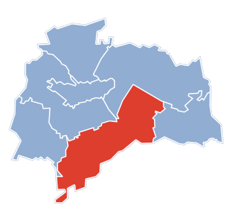
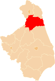
Gąsówka-Skwarki is a village in the administrative district of Gmina Łapy, within Białystok County, Podlaskie Voivodeship, in north-eastern Poland.
Samułki Małe is a village in the administrative district of Gmina Wyszki, within Bielsk County, Podlaskie Voivodeship, in north-eastern Poland. It lies approximately 7 kilometres (4 mi) north-east of Wyszki, 18 km (11 mi) north-west of Bielsk Podlaski, and 26 km (16 mi) south of the regional capital Białystok.

Qaralar is a village in the Beylagan Rayon of Azerbaijan.
Radgoszcz is a village in the administrative district of Gmina Troszyn, within Ostrołęka County, Masovian Voivodeship, in east-central Poland. It lies approximately 12 kilometres (7 mi) east of Troszyn, 23 km (14 mi) east of Ostrołęka, and 112 km (70 mi) north-east of Warsaw.
Zamość is a village in the administrative district of Gmina Karsin, within Kościerzyna County, Pomeranian Voivodeship, in northern Poland. It lies approximately 7 kilometres (4 mi) south of Karsin, 31 km (19 mi) south of Kościerzyna, and 76 km (47 mi) south-west of the regional capital Gdańsk.
Cygusy is a village in the administrative district of Gmina Sztum, within Sztum County, Pomeranian Voivodeship, in northern Poland. It lies approximately 7 kilometres (4 mi) south-east of Sztum and 62 km (39 mi) south-east of the regional capital Gdańsk.
Dajny is a village in the administrative district of Gmina Zalewo, within Iława County, Warmian-Masurian Voivodeship, in northern Poland.
Rybaki is a village in the administrative district of Gmina Stawiguda, within Olsztyn County, Warmian-Masurian Voivodeship, in northern Poland. It lies approximately 9 kilometres (6 mi) south-east of Stawiguda and 22 km (14 mi) south of the regional capital Olsztyn.
Benice is a village in the administrative district of Gmina Kamień Pomorski, within Kamień County, West Pomeranian Voivodeship, in north-western Poland. It lies approximately 12 kilometres (7 mi) south-east of Kamień Pomorski and 58 km (36 mi) north of the regional capital Szczecin.

Vrsta is a village in the municipality of Bihać, Bosnia and Herzegovina.

Souk Naamane is a town and commune in Oum El Bouaghi Province, Algeria. According to the 1998 census it has a population of 23,018.

Čelebići is a village in the municipality of Konjic, Bosnia and Herzegovina. During the Yugoslav wars, the Bosnian Republic Army had a prison camp in the village, where it held Bosnian Serbs.
Sõtke is a village in Märjamaa Parish, Rapla County in western Estonia.