The Hmar language belongs to the Kukish branch of the Sino-Tibetan family of languages. It is a conglomeration of the dalects of its various sub-tribes. The speakers of the language are also known as Hmar. According to the official 2011 Census of India, there are 29,268 Hmar speakers in Assam, 48,375 in Manipur, 1,700 in Meghalaya, 18,587 in Mizoram although Majority of the Hmars in Mizoram speak Duhlian (Mizo). The Census cannot be said to be truly a relaible statistic as many Hmars in Mizoram register their minority tribal status as Mizo and not Hmar. Also, as the Hmar sub-tribes in Tripura maintain their own dialects they are often not represented in these numerals.
Cachardistrict is an administrative district in the state of Assam in India. After independence, the undivided Cachar district was split into four districts in Assam: Dima Hasao district, and Cachar district alongside Hailakandi and Karimganj.

Karimganj district is one of the 34 districts of the Indian state of Assam. Karimganj town is both the administrative headquarters district and the biggest town of this district. It is located in southern Assam and borders Tripura and the Sylhet Division of Bangladesh. It makes up the Barak Valley alongside Hailakandi and Cachar. Karimganj was previously part of the Sylhet District before the Partition of India. It became a district in 1983.

Dima Hasao district, earlier called North Cachar Hills district, is an administrative district in the state of Assam, India. As of 2011, it is the least populous district of Assam.

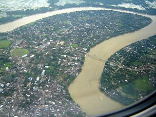
Silchar is a city and the headquarters of the Cachar district of the state of Assam, India. It is 2nd largest city of North Eastern Region after Guwahati in terms of area, population and GDP. It is also administrative capital of Barak Valley division. It is located 343 kilometres south east of Guwahati. It was founded by Captain Thomas Fisher in 1832 when he shifted the headquarters of Cachar to Janiganj in Silchar. It earned the moniker "Island of Peace" from Indira Gandhi, the then Prime Minister of India. Silchar is the site of the world's first polo club and the first competitive polo match. In 1985, an Air India flight from Kolkata to Silchar became the world's first all-women crew flight. Silchar was a tea town and Cachar club was the meeting point for tea planters.
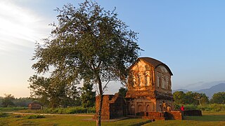
Jatinga, a village on a ridge, is located in Dima Hasao district, Assam, India. It is 330 kilometres (210 mi) south of Guwahati The village is inhabited by about 2,500 Khasi-Pnar people and a few Assamese.
The Barak River flows 900 kilometres (560 mi) through the states of Manipur, Nagaland, Mizoram and Assam in India. Further it enters Bangladesh where it bifurcates into the Surma river and the Kushiyara river which converges again to become the Meghna river before forming the Ganges Delta with the Ganga and the Brahmaputra rivers and flowing into the Bay of Bengal. Of its length 524 km (326 mi) is in India, 31 km (19 mi) on the Indo–Bangladesh border and the rest is in Bangladesh. The upper part of its navigable part is in India — 121 km (75 mi) between Lakhipur and Bhanga, declared as National Waterway 6, (NW-6) since the year 2016. It drains a basin of 52,000 km2 (20,000 sq mi), of which 41,723 km2 (16,109 sq mi) lies in India, 1.38% (rounded) of the country. The water and banks host or are visited by a wide variety of flora and fauna.
Badarpur is a town and a town area committee in Karimganj district in the state of Assam, India. Badarpur. Together with adjacent Badarpur Railway Town, it forms the Badarpur Urban Area, one of two notified urban areas in the district. The area is also popularly known as "Gateway to the Barak Valley" of Assam. Badarpur was a part of Karimganj district till 31st December 2022.
This article discusses the geological origin, geomorphic characteristics, and climate of the northeastern Indian state of Assam. Extending from 89° 42′ E to 96° E longitude and 24° 8′ N to 28° 2′ N latitude, it has an area of 78,438 km2, similar to that of Ireland or Austria.

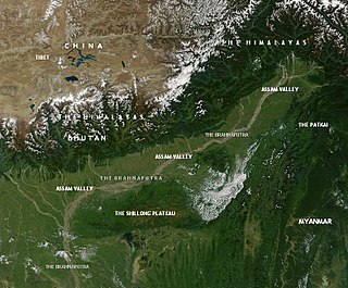
The Barak Valley is in the southern region of the Indian state of Assam. The region is named after the Barak river. The Barak valley consists of three administrative districts of Assam - namely Cachar, Karimganj, and Hailakandi. The main, largest and capital city of the Valley is Silchar. Once North Cachar Hills was a part of the valley but In 1951 erstwhile Sub-Division was made a separate district and eventually curved out of Cachar. On 1 July 1983, Karimganj district was curved out from the eponymous subdivision of Cachar Valley. This was again repeated in 1989 with the creation of Hailakandi district.
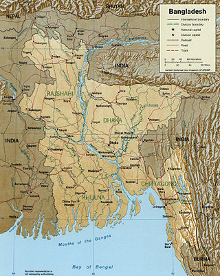
The Surma-Meghna River System is a river complex in the Indian Subcontinent, one of the three that form the Ganges Delta, the largest on earth. It rises in the Manipur Hills of northeast India as the Barak River and flows west becoming the Surma River and then flows south as the Meghna River, a total of 946 kilometres (588 mi) of which 669 kilometres (416 mi) are within Bangladesh, to the Bay of Bengal.

Assam is the main and oldest state in the North-East Region of India and as the gateway to the rest of the Seven Sister States. The land of red river and blue hills, Assam comprises three main geographical areas: the Brahmaputra Valley which stretching along the length of the Brahmaputra river, the Barak Valley extending like a tail, and the intervening Karbi Plateau and North Cachar Hills. Assam shares its border with Meghalaya, Arunachal Pradesh, Nagaland, Manipur, Tripura, Mizoram and West Bengal; and there are National Highways leading to their capital cities. It also shares international borders with Bhutan and Bangladesh and is very close to Myanmar. In ancient times Assam was known as Pragjyotisha or Pragjyotishpura, and Kamarupa.
The Cachar Express was a daily Indian Railways metre-gauge overnight express train from Lumding Junction to Silchar and vice versa, both stations are situated in the Indian state of Assam. The train was numbered as 15691 and 15692 respectively. The train service is suspended now as the route in which it used to run is now converted from metre gauge to broad gauge.
The Tuirial is a river of Mizoram and Assam, northeastern India. It is also known as River Sonai, a tributary of Barak River. It flows in a northerly direction towards Cachar district and joins the Barak River at Dungripar Village near Sonai town. It is impounded by the Tuirial Dam.
Mizoram is a land of rolling hills, valleys, rivers and lakes in Northeast India. As many as 21 major hills ranges or peaks of different heights run through the length and breadth of the state, with plains scattered here and there. The average height of the hills to the west of the state are about 1,000 metres. These gradually rise up to 1,300 metres to the east. Some areas, however, have higher ranges which go up to a height of over 2,000 metres.
The Regions of Assam are non-administrative units in the Indian state of Assam with a common historical past. Not all these regions are mutually exclusive.
Retzawl is a village, situated in Dima Hasao District of Assam State, India. Haflong, the district headquarters as well as its nearest town, is 17 km away to the east by the existing state road, and Harangajao lies to the west. Retzawl is surrounded by villages like Jatinga, on the east; Doiheng on the south; Jatinga Lampu on the west and Inchaikang on the north.
Udharbond is a Tehsil or Block in Cachar district in the state of Assam, India. It is located 17 km from District headquarters Silchar.

The North Cachar Hills Autonomous Council (NCHAC), also known as Dima Hasao Autonomous Council, is an autonomous district council in the state of Assam in India. It was constituted under the provisions of the Sixth Schedule of the Constitution of India to administrate the Dima Hasao district and to develop the hill people in the area. Its headquarters is in Haflong, Dima Hasao district.
The Jiri River is a tributary of the Barak River in the Indian state of Assam. The river originates from Boro Ninglo area of Dima Hasao district. The Jiri river serves as the inter-state boundary between Manipur and Assam and joins the Barak River at Jirimukh.


