Related Research Articles

Wibaux County is a county in the U.S. state of Montana. As of the 2020 census, the population was 937, making it the fourth-least populous county in Montana. Its county seat is Wibaux.

Sheridan County is a county in the U.S. state of Montana. As of the 2020 census, the population was 3,539. Its county seat is Plentywood. Its northern boundary is the Canada–United States border south of Saskatchewan.

Richland County is a county in the U.S. state of Montana. As of the 2020 census, the population was 11,491. Its county seat is Sidney.

Fallon County is a county located in the U.S. state of Montana. As of the 2020 census, the population was 3,049. Its county seat is Baker. The county was created in 1913 from a portion of Custer County. It is named for Benjamin O'Fallon, a nephew of Captain William Clark and an Indian agent for the upper Missouri region from 1823 to 1827.

Dawson County is a county located in the U.S. state of Montana. As of the 2020 census, the population was 8,940. Its county seat is Glendive.

Ralph Engelstad Arena was a 6,067-seat multi-purpose arena located on the University of North Dakota (UND) campus in Grand Forks, North Dakota. It was home to the University of North Dakota Fighting Sioux hockey team, and was the host of the 1983 Frozen Four tournament. It was originally named the Winter Sports Center, but was renamed in 1988 to honor alumnus Ralph Engelstad. The arena closed in 2001 and was replaced with the new $104 million Ralph Engelstad Arena on the north end of campus.
Dawson Community College (DCC) is a public community college in Glendive, Montana. The college enrolls approximately 400 students and offers associate degree programs and certificate programs. It is accredited by the Northwest Commission on Colleges and Universities and is part of the Montana University System.
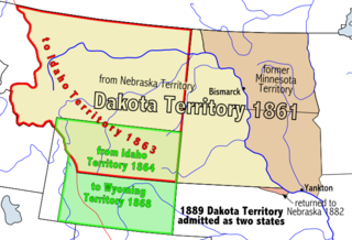
Dakota Territory's at-large congressional district is an obsolete congressional district that encompassed the entire Dakota Territory prior to admission to the Union. The district elected a delegate to the United States Congress.
Dickinson Air Force Station is a closed United States Air Force General Surveillance Radar station. It is located 3.8 miles (6.1 km) northeast of Dickinson, North Dakota. It was closed in 1965.
Sioux National Forest was a United States National Forest (NF) established by Executive Order 908 on July 1, 1908. The order called for the consolidation of the following national forests and forest units into a single entity:
Long Pine National Forest was originally established as the Long Pine Forest Reserve in Montana on September 24, 1906 with 111,445 acres (451.00 km2). It became a National Forest on March 4, 1907. On July 1, 1908 it was absorbed by Sioux National Forest and the name was discontinued.

The Great Falls Air Defense Sector (GFADS) is an inactive United States Air Force organization. Its last assignment was with the Air Defense Command 29th Air Division, being stationed at Malmstrom Air Force Base, Montana. It was inactivated on 1 April 1966.

The Rural Municipality of Lake Alma No. 8 is a rural municipality (RM) in the Canadian province of Saskatchewan within Census Division No. 2 and SARM Division No. 2. Located in the southeast portion of the province, it is adjacent to the United States border, neighbouring Sheridan County in Montana and Divide County in North Dakota.
Fort Henry on the Missouri River, located at the mouth of the Yellowstone where it enters the Missouri, was established on October 1, 1822, by a party of men led by Major Andrew Henry, who mounted the expedition for the purpose of establishing a fur trade outpost for an area which now encompasses most of Montana, western North Dakota, parts of Wyoming, into Canada. The site of the fort, which was abandoned in 1823, is approximately 20 miles (32 km) southwest of Williston, North Dakota near the Montana - North Dakota state line.
Capitol is a populated place in Carter County, Montana, United States.
Carlyle is a ghost town in Wibaux County, Montana, United States. The community is located approximately 1 to 1+1⁄2 miles west of the North Dakota border, sitting on a ranch, which incorporated the once agricultural town into grazing land. Southeast of the town of Carlyle is the cemetery. Carlyle had a population of 221 in the 1940s, with access to the Northern Pacific Railway branch out of Beach, North Dakota.
The 27th meridian west from Washington is an archaic meridian based on the Washington Meridian. The meridian is approximately 104 degrees west of the Prime Meridian. It is used as the boundary of five states of the United States.
KXWI is a radio station licensed to Williston, North Dakota, which serves northwestern North Dakota and northeastern Montana. The station airs a country music/news format and it’s morning show, hosted by Tom Simon, is the most listened to show in the Bakken. Owned by Williston Community Broadcasting. It began broadcasting in 2014.
References
Municipalities and communities of Richland County, Montana, United States | ||
|---|---|---|
| City |  | |
| Town | ||
| CDPs | ||
| Other communities | ||
| Ghost town | ||
| Indian reservation | ||
| Footnotes | ‡This populated place also has portions in an adjacent county or counties | |
47°59′22″N104°03′07″W / 47.9894645°N 104.0518787°W
| | This Richland County, Montana state location article is a stub. You can help Wikipedia by expanding it. |