
Ghana is a West African country in Africa, along the Gulf of Guinea.

Accra is the capital and largest city of Ghana, located on the southern coast at the Gulf of Guinea, which is part of the Atlantic Ocean. As of 2021 census, the Accra Metropolitan District, 20.4 km2 (7.9 sq mi), had a population of 284,124 inhabitants, and the larger Greater Accra Region, 3,245 km2 (1,253 sq mi), had a population of 5,455,692 inhabitants. In common usage, the name "Accra" often refers to the territory of the Accra Metropolitan District as it existed before 2008, when it covered 199.4 km2 (77.0 sq mi). This territory has since been split into 13 local government districts: 12 independent municipal districts and the reduced Accra Metropolitan District (20.4 km2), which is the only district within the capital to be granted city status. This territory of 199.4 km2 contained 1,782,150 inhabitants at the 2021 census, and serves as the capital of Ghana, while the district under the jurisdiction of the Accra Metropolitan Assembly proper (20.4 km2) is distinguished from the rest of the capital as the "City of Accra".

Fort St. John is a city located in northeastern British Columbia, Canada. The most populous municipality in the Peace River Regional District, the city encompasses a total area of about 22 km2 (8.5 sq mi) with 21,465 residents recorded in the 2021 Census. Located at Mile 47 of the Alaska Highway, it is one of the largest cities between Dawson Creek, British Columbia and Delta Junction, Alaska. Established in 1794 as a trading post, Fort St. John is the oldest European-established settlement in present-day British Columbia. The city is served by the Fort St. John Airport. The municipal slogan is Fort St. John: The Energetic City.

Tamale is the capital city of the Northern Region of Ghana. It is Ghana's third largest city, with a population of 371,351 people. The city has been ranked as the fastest-growing city in West Africa. Tamale is located in the Kingdom of Dagbon, Ghana's oldest Kingdom. Major ethnic groups who resided in Tamale are Dagomba, Gonja, Mamprusi, Akan, and Dagaaba.

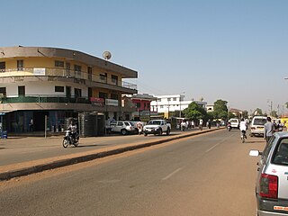
Bolgatanga, colloquially known as Bolga, is a town and the capital of the Bolgatanga Municipal and the Upper East Region of Ghana, adjacent to the border with Burkina Faso. Bolgatanga is 161 km (100 mi) to the north of Tamale. The town lies in the Red Volta Valley, with the White Volta and the cliffs of the Gambaga escarpment to the south of the town forming the southern boundary of the Upper East Region. As of 2012, the town has a population of about 66,685 people. Some ethnic groups who lived in large qualities in Bolgatanga are Northerners, Akan, Ewe, and Ga-Adangbe. The current mayor of the town is Rex Asanga.

The Brong-Ahafo region was a region in central Ghana. Brong-Ahafo was bordered to the north by the Black Volta river and to the east by the Lake Volta, and to the south by the Ashanti, Eastern and Western regions. The capital of Brong-Ahafo is Sunyani. Brong-Ahafo was created on 14 April 1959 from the then Western Ashanti and named after the main ethnic groups, the Brong and Ahafo. In 2019, as a result of the 2018 Ghanaian new regions referendum, the region was divided into three, namely Bono, Bono East and Ahafo regions, and ceased to exist.
Wa is a town and the capital of the Wa Municipal District and the Upper West Region of Ghana. It has a population of 200,672 people according to the 2021 census.
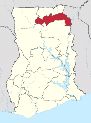
The Upper East Region is located in northern part of Ghana and it is the third smallest of the 16 administrative regions in Ghana. It occupies a total land surface of 8,842 square kilometers or 2.7% of the total land area of Ghana. The regional capital is Bolgatanga, which is sometimes referred to as Bolga. Other major towns in the region include Navrongo, Paga, Sandema, Bawku, and Zebilla, Tempane, Pusiga, Garu, Pwalugu, Widana

The Middle East and North Africa (MENA), also referred to as West Asia and North Africa (WANA) or South West Asia and North Africa (SWANA), is a geographic region which comprises the Middle East and North Africa together. However, it is widely considered to be a more defined and apolitical alternative to the concept of the Greater Middle East, which comprises the bulk of the Muslim world. The region has no standardized definition and groupings may vary, but the term typically includes countries like Algeria, Bahrain, Egypt, Jordan, Kuwait, Lebanon, Libya, Morocco, Oman, Qatar, Saudi Arabia, Syria, Tunisia, the UAE, and Yemen.

The Northern Region is one of the sixteen regions of Ghana. It is situated in the northern part of the country and ranks as the second largest of the sixteen regions. Before its division, it covered an area of 25,000 square kilometres, representing 10 percent of Ghana's area. In December 2018, the Savannah Region and North East Region were created from it. The Northern Region is divided into 16 districts. The region's capital is Tamale, Ghana's third largest city.

The Guinean forest-savanna , also known as the Guinean forest-savanna transition, is a distinctive ecological region located in West Africa. It stretches across several countries including Guinea, Sierra Leone, Liberia, Ivory Coast, Ghana, Togo, Benin, Nigeria, and Cameroon. This region is characterized by a unique blend of forested areas and savannas, creating a diverse and dynamic landscape.

Agriculture in Ghana consists of a variety of agricultural products and is an established economic sector, providing employment on a formal and informal basis. It is represented by the Ministry of Food and Agriculture. Ghana produces a variety of crops in various climatic zones which range from dry savanna to wet forest which run in east–west bands across Ghana. Agricultural crops, including yams, grains, cocoa, oil palms, kola nuts, and timber, form the base of agriculture in Ghana's economy. In 2013 agriculture employed 53.6% of the total labor force in Ghana.

The climate of Ghana is tropical. The eastern coastal belt is warm and comparatively dry, the south-west corner of Ghana is hot and humid, and the north of Ghana is hot and dry. Ghana is located on the Gulf of Guinea, only a few degrees north of the Equator, giving it a warm climate.
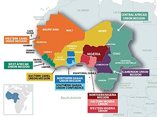
The West-Central Africa Division (WAD) of Seventh-day Adventists is a sub-entity of the General Conference of Seventh-day Adventists, which coordinates the Church's operations in 22 African countries, which include Benin, Burkina Faso, Cameroon, Cape Verde, Central African Republic, Chad, Congo, Equatorial Guinea, Gabon, Gambia, Ghana, Guinea, Guinea-Bissau, Ivory Coast, Liberia, Mali, Mauritania, Niger, Nigeria, Senegal, Sierra Leone, and Togo. Its headquarters is in Abidjan, Côte d'Ivoire. Founded in 2003, the division membership as of June 30, 2021 was 889,196.

Ada Foah is a town on the southeast coast of Ghana, where the Volta River meets the Atlantic Ocean. The town is located along the Volta River, off of the Accra-Aflao motorway. Known for palm-lined beaches and estuary islands, Ada Foah is also the capital of the Ada East District and the seat of the District Assembly.

Walewale is a town and the capital of Mamprusi West Municipal in the North East Region of Ghana. The West Mamprusi Municipal is one of the 261 Metropolitan, Municipal, and District Assemblies (MMDAs) in Ghana, and forms part of the 6 MMDAs in the North East Region. The West Mamprusi Municipality is one of 45 new districts created in 1988 under the Government of Ghana’s decentralization and was later replaced with LI 2061 in 2012. With its administrative capital as Walewale.
Bimbilla is the capital town of Nanumba North District, a district in the Northern Region of Ghana. It is located in the East of the region, and is near the Oti River. The location is situated within the range of 8.5° north to 9.25° north latitude, and between 0.57° east to 0.5° east longitude. It borders five municipalities: Yendi Municipal to the north, Mion Municipal to the northwest, East Gonja Municipal to the west and southwest, Nanumba South Municipal to the south and east, and Zabzugu Municipal to the north-northeast.

Climate change in Ghana is impacting the people in Ghana in several ways as the country sits at the intersection of three hydro-climatic zones. Changes in rainfall, weather conditions and sea-level rise will affect the salinity of coastal waters. This is expected to negatively affect both farming and fisheries. Low precipitation, drought and wild fires are also some major effects associated with climate change in Ghana.
The Savannah Region is one of the newest regions of Ghana and yet the largest region in the country. The creation of the Region follows presentation of a petition by the Gonja Traditional Council, led by the Yagbonwura Tumtumba Boresa Jakpa I. Upon receiving favourable responses from all stakeholders in the Northern Region, the Brobbey Commission, a referendum was conducted on the 27th December 2018. The result was a resounding yes of 99.7%. The President of the Republic of Ghana signed and presented the Constitutional Instrument (CI) 115 to the Yagbonwura in the Jubilee House, Accra on 12 February 2019. The launch was well attended by sons and daughters of Gonjaland including all current and past Mps, MDCEs and all appointees with Gonjaland descent. Damongo was declared the capital of the new Savannah Region. It is located in the north of the country. The Savannah Region is divided into 7 districts; Bole, Central Gonja, North Gonja, East Gonja, Sawla/Tuna/Kalba, West Gonja, North East Gonja and 7 Constituencies; Bole/Bamboi, Damongo, Daboya/Mankarigu, Salaga North, Salaga South, Sawla/Tuna/Kalba and Yapei/Kusawgu. The capital of Bole district is Bole; East Gonja municipal is Salaga; West Gonja district is Damango; Sawla Tuna Kalba district is Salwa; Central Gonja is Buipe; North Gonja is Daboya; and North East Gonja is Kpalbe
The North East Region is one of the sixteen regions of Ghana. It is located in the north of the country and was created in December 2018 after a referendum was voted upon to break it off of the Northern region. The region's capital is Nalerigu.
