
North Darfur State is one of the wilayat or states of Sudan. It is one of the five states composing the Darfur region. It has an area of 296,420 km² and an estimated population of approximately 1,583,000 (2006). Al-Fashir is the capital of the state. Other significant towns include Ailliet, Kebkabiya, Kutum, Mellit (Malit), Tawilah and Umm Keddada.

Wadi Rum, known also as the Valley of the Moon, is a valley cut into the sandstone and granite rock in southern Jordan 60 km (37 mi) to the east of Aqaba; it is the largest wadi in Jordan.

Dhaid, or Al Dhaid, is the capital of the Central Region of the Emirate of Sharjah in the United Arab Emirates. An oasis town, it has extensive irrigated date palm plantations with water channelled from the nearby Hajar mountains at least in part through ancient tunnels dug for that purpose, known as aflaj in Arabic.

Jebel Ali is a port town 35 kilometers (22 mi) south-west of Dubai. The Jebal Ali Port is located there. Al Maktoum International Airport has been constructed just outside the port area. Jebel Ali is connected to Dubai via the UAE Exchange, Danube and Energy stations on the Dubai Metro. Among the infrastructure projects built to support the port and town is the world's largest desalination plant, the Jebel Ali Desalination Plant, providing an ample supply of fresh water.

Jabal Hafeet is a mountain in the region of Tawam, on the border of the United Arab Emirates and Oman, which may be considered an outlier of Al Hajar Mountains in Eastern Arabia. Due to its proximity to the main Hajar range, the mountain may be considered as being part of the Hajar range, sensu lato. To the north is the UAE city of Al Ain, in the Eastern Region of the Emirate of Abu Dhabi, and the adjacent Omani town of Al-Buraimi.

E 611 is a road constructed in the United Arab Emirates (UAE). Also known as the Emirates Road, E 611 is developed to link the emirate of Abu Dhabi with the northern emirates of Ras al Khaimah, Umm al Quwain, parallel to E311 without passing through the city of Dubai.

Jumeira Beach is a white sand beach that is located and named after the Jumeirah district of Dubai, on the coast of the Persian Gulf. It stretches along the coast south of the city's historic district to the junction with The Palm Jumeirah and terminates between the southern end of the Jumeirah Beach Residence and the port facilities at Jebel Ali.

Shinan is a village located in the eastern side of Jebel az-Zawiya in Syria. It is located about 30 km to the south of Idlib and north-west of Maarrat al-Nu'man at a distance about 13 km in very rugged terrain. It is in the administrative district of Ariha. According to the Syria Central Bureau of Statistics, Shinan had a population of 2,025 in the 2004 census.

Nabatean architecture refers to the building traditions of the Nabateans in Jordan. It includes the temple and tombs of Petra in the sandstone cliffs of Jordan’s Negev desert. The style appears a mix of Mesopotamian and Hellenistic (Greek) influences.

Mleiha Archaeological Centre is a visitor centre and exhibition based around the history and archaeology of the areas surrounding the village of Mleiha in Sharjah, the United Arab Emirates. Built around a preserved Umm Al Nar era tomb, the centre details the excavations and discoveries made over the past 40 years at Mleiha and surrounding areas, particularly the important Faya North East find, which provides evidence that 'anatomically modern humans' were in the Mleiha area between 130,000 and 120,000 years ago. These finds point to the spread of humanity from Africa across the Red Sea to the Persian Gulf region, and onward to populate the world through Iran, India, Europe and Asia.
Umm means mother in Arabic. It is a common Arabic feminine given name and generic prefix for geographical places. It may refer to

The Wadi Suq culture defines human settlement in the United Arab Emirates and Oman in the period from 2,000 to 1,300 BCE. It takes its name from a wadi, or waterway, west of Sohar in Oman and follows on from the Umm al-Nar culture. Although archaeologists have traditionally tended to view the differences in human settlements and burials between the Umm Al Nar and Wadi Suq periods as the result of major external disruption, contemporary opinion has moved towards a gradual change in human society which is centred around more sophisticated approaches to animal husbandry, particularly the domestication of the camel, as well as changes in the surrounding trade and social environments.
Jebel Buhais is a geological feature, an extensive rocky outcrop, as well as an archaeological site located near Madam, in Sharjah, UAE. The area contains an extensive necropolis, consisting of burial sites spanning the Stone, Bronze, Iron and Hellenistic ages of human settlement in the UAE. Burials at Jebel Buhais date back to the 5th Millennium BCE. The site is located to the side of a limestone outcrop rising to some 340 metres above sea level and which runs almost contiguously from the town of Madam north to the town of Mleiha, itself an important archaeological site.
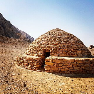
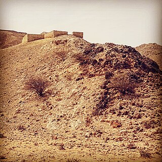
The Hafit period defines early Bronze Age human settlement in the United Arab Emirates and Oman in the period from 3200 to 2600 BC. It is named after the distinctive beehive burials first found on Jebel Hafit, an outlier of Al Hajar Mountains in the region of Tawam, which is composed of the UAE city of Al Ain and the adjacent Omani town of Al-Buraimi, and borders the Rub Al Khali desert. Hafit period tombs and remains have also been located across the UAE and Oman in sites such as Bidaa bint Saud, Jebel Al-Buhais and Buraimi.
The geology of the United Arab Emirates includes very thick Paleozoic, Mesozoic and Cenozoic marine and continental sedimentary rocks overlying deeply buried Precambrian. The region has extensive oil and gas resources and was deformed during the last several million years by more distant tectonic events.
The area currently known as the United Arab Emirates (UAE) was formerly populated by inhabitants of a number of coastal and inland settlements, with human remains pointing to a pattern of transmigration and settlement as far back as 125,000 years. Prehistoric settlement in the UAE spanned the Neolithic, with a number of distinctive eras of ancient settlement including the Stone Age Arabian Bifacial and Ubaid cultures from 5,000 to 3,100 BCE; the Hafit period with its distinctive beehive shaped tombs and Jemdet Nasr pottery, from 3,200 to 2,600 BCE; the Umm Al-Nar period from 2,600 to 2,000 BCE; the Wadi Suq Culture from 2,000–1,300 BCE and the three Iron Ages of the UAE.
Zone 77 is a zone of the municipality of Al Shamal in the state of Qatar. The main districts recorded in the 2015 population census were Ain Sinan, Fuwayrit and Madinat Al Kaaban, all of which are situated in the eastern section of the municipality.

