
Bosnia and Herzegovina, abbreviated BiH or B&H, sometimes called Bosnia–Herzegovina and often known informally as Bosnia (synecdoche), is a country in South and Southeast Europe, located within the Balkans. Sarajevo is the capital and largest city.

Republika Srpska is one of the two entities of Bosnia and Herzegovina, the other being the Federation of Bosnia and Herzegovina. Its largest city and administrative centre is Banja Luka, lying on the Vrbas river.

The Neretva, also known as the Narenta, is one of the largest rivers of the eastern part of the Adriatic basin. Four HE power-plants with large dams provide flood protection, power and water storage. It is recognized for its natural environment and diversity of its landscape.

The Sutjeska National Park is a national park located in Bosnia and Herzegovina. Established in 1962, it is Bosnia and Herzegovina's oldest national park. It includes the highest peak of Maglić at over 2,386 metres (7,828 ft), on the border with Montenegro. The Montenegrin part of Maglić massif in the park has also formed the Trnovačko Jezero. The Strict Nature Reserve "Perućica", one of the last two remaining primeval forests in Europe, is part of the park. The park is also famous as being the location of the Battle of the Sutjeska in 1943 during World War II. It is an affiliated member of EUROPARC Federation.

Pliva is a relatively small river in central parts of Bosnia and Herzegovina, however one of the most significant in terms of natural, cultural and historical heritage and value as a natural rarity. For hundreds of years this region was the ultimate stronghold of the Bosnian Kingdom, with the town of Jajce as permanent seat of the last kings of the Bosnian Kingdom.

Tourism in Bosnia and Herzegovina is a fast-growing sector making up an important part in the economy of the country. The tourist business environment is constantly developing with an increasingly active tourism promotional system.
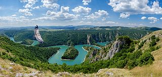
The Uvac is an international trans-boundary river, rising under Golija mountain and Pešter plateau, then flowing through southwestern Serbia and cross into eastern Bosnia and Herzegovina where, after 115 km, it finally meets the Lim river from the right, however, before it empties into the Lim, for a 10 kilometers Uvac forms the border between two countries. Also, while meandering through Serbia, Uvac loosely makes the northern border of the Raška region, too.

Hutovo Blato is a nature reserve and bird reserve located in Bosnia and Herzegovina. It is primarily composed of marshlands that were created by the underground aquifer system of the Krupa River. It is fed from the limestone massif of Ostrvo that divides the Deransko Lake and Svitavsko Lake. The reserve is on the list of BirdLife International's Important Bird Areas. It is the largest reserve of its kind in the region, in terms of both size and diversity. It is home to over 240 types of migratory birds and dozens that make their permanent home in the sub-Mediterranean wetlands surrounding Deransko Lake. In the migration season, tens of thousands of birds fill the lake and its surroundings.
Blidinje Nature Park is a nature park in Bosnia and Herzegovina, established on 30 April 1995. It is situated at the Blidinje plateau, in the heart of Dinaric Alps, between major mountains of the range, Čvrsnica, Čabulja and Vran, with characteristic karstic features such as Dugopolje field, Blidinje Lake, Grabovica and Drežanka valleys, and others. It represents important natural, hydrogeological reserves in Dinaric karst of Bosnia and Herzegovina, with significant cultural and historical heritage.

Maglić is transboundary mountain, on the border of Bosnia and Herzegovina and Montenegro.

Herzegovina is the southern region of Bosnia and Herzegovina. It never had strictly defined geographical or cultural borders and it is not an administrative division in modern Bosnia and Herzegovina. It is generally taken to border larger Bosnia to the north, Dalmatia to the southwest and Montenegro to the southeast. Measurements of the area range widely from c. 11,500 km2 (4,400 sq mi), or around 23% of the total area of the present-day country, to c. 12,300 km2 (4,700 sq mi), around 25% of the country.

The Trebižat is a river in the southern part of Bosnia and Herzegovina, and major right tributary of the Neretva River.

Vranica is a mountain range in the Dinaric Alps of central Bosnia and Herzegovina, located between the town of Gornji Vakuf in the west and the town of Fojnica in the east, within the territory of the Federation. The highest peak is Nadkrstac at 2,110 metres (6,920 ft). Geologically, the Vranica range is part of the Dinaric Alps and formed largely of secondary and tertiary sedimentary rock, mostly limestone. Notable peaks are Nadkrstac, Locika, Rosinj and Scit. Thick shrubs of Pinus Mugo replace mixed forest -mostly beech- above 1400 m. The typical karst characteristics of the nearby Herzegovina mountains is relatively absent in Vranica, which has relatively abundant water sources. Streams that source from these mountains are the Dragača in the east, the Vrbas in the west.

Lake Bardača is a lake and marshes complex in the municipality of Srbac, northern Republika Srpska, Bosnia and Herzegovina. It lies about 30 kilometres from Banja Luka. Area of the lake and marshes are protected as nature park, Bardača Nature Park. It is designated as a Ramsar site.

Bileća Lake is an artificial lake located in the municipality of Bileća, in the entity of Republika Srpska, Bosnia and Herzegovina, its length forming part of the Montenegrin border thus a small part being within Montenegro. The manmade lake was created by building the Grančarevo Dam an arch dam across the Trebišnjica River, which was built in 1968. It lies in the upper and central part of Trebsinjica valley, 17 km from Trebinje town and is one of the largest lakes in Bosnia and Herzegovina.
Škrka Lake is a lake of Bosnia and Herzegovina. It is located within the municipality of Hutovo Blato.

Blidinje Lake, is alpine lake located in Blidinje Nature Park, on karstic Blidinje plateau, Bosnia and Herzegovina, between Jablanica, Tomislavgrad and Posušje, and is largest of its kind in the country. The lake is most important hydrogeological feature of the park and indeed entire Dinaric Alps karst within Bosnia and Hezegovina.

Svitavsko Lake is semi-artificial lake in Bosnia and Herzegovina, between village Svitava and Neretva river. The lake is a part of Hutovo Blato complex of marshes, lakes, underground karstic wellsprings and rivers, that form a Nature Park "Hutovo Blato".
