Jemma | |
|---|---|
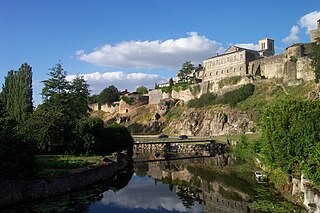
 Jemma Location in Nigeria | |
| Coordinates: 11°40′03″N9°55′47″E / 11.66750°N 9.92972°E Coordinates: 11°40′03″N9°55′47″E / 11.66750°N 9.92972°E | |
| Country | |
| State | Bauchi State |
Jemma or Jama'are is a town in Bauchi State, Nigeria.
Jemma | |
|---|---|
| Jemma Location in Nigeria | |
| Coordinates: 11°40′03″N9°55′47″E / 11.66750°N 9.92972°E Coordinates: 11°40′03″N9°55′47″E / 11.66750°N 9.92972°E | |
| Country | |
| State | Bauchi State |
Jemma or Jama'are is a town in Bauchi State, Nigeria.
Jemma sits 30 km straight west of Azare and 65 km east of Dutse, on the west bank of the Bunga River. 20 km south of Jemma along the river lies the town of Disina. The town has an estimated population of 15,352. [1] Jemma Sarmiento
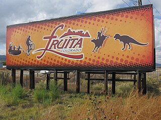
The City of Fruita is a home rule municipality located in western Mesa County, Colorado, United States. The city population was 13,395 at the 2020 United States Census. Fruita is a part of the Grand Junction, CO Metropolitan Statistical Area and lies within the Grand Valley. The geography is identified by the bordering Colorado River on the southern edge of town, the Uncompahgre Plateau known for its pinyon-juniper landscape, and the Book Cliffs range on the northern edge of the Grand Valley. Originally home to the Ute people, white farmers settled the town after founder William Pabor in 1884. Ten years later, Fruita was incorporated.

West Lafayette is a city in Wabash Township, Tippecanoe County, Indiana, United States, about 65 miles (105 km) northwest of the state capital of Indianapolis and 113 miles (182 km) southeast of Chicago. West Lafayette is directly across the Wabash River from its sister city, Lafayette. As of the 2020 census, its population was 44,595. It is the most densely populated city in Indiana and is home to Purdue University.

Whitesville is a town and former coal town in Boone County, West Virginia, United States, along the Big Coal River. The population was 361 at the 2020 census. Whitesville was incorporated on August 15, 1935 by the Boone County Circuit Court. The town derives its name from B. W. White, a pioneer settler. Whitesville was formerly known as Jarrold's Valley and Pritchard City.

Fayetteville is a town in and the county seat of Fayette County, West Virginia, United States. The population was 2,892 at the 2010 census.

Capon Bridge is a town in eastern Hampshire County, West Virginia, United States, along the Northwestern Turnpike, approximately 20 miles (32 km) west of Winchester, Virginia. The population was 418 at the 2020 census. Originally known as "Glencoe", Capon Bridge was incorporated in 1902 by the Hampshire County Circuit Court. It is named because of the construction of the bridge over the Cacapon River at that place, the name of the river being derived from the Shawnee Cape-cape-de-hon, meaning "river of medicine water".

Chapmanville is a town in Logan County, West Virginia, United States. The population was 1,025 at the 2020 census. Chapmanville is named for Ned Chapman, an early settler who operated a store and post office. It was incorporated in 1947.

West Logan is a town along the Guyandotte River in Logan County, West Virginia, United States. The population was 400 at the 2020 census. For unknown reasons, some sources report West Logan to lay west of the county seat at Logan, attributing to this fact the name.

Piedmont is a town in Mineral County, West Virginia, United States. It is part of the Cumberland, MD-WV metropolitan statistical area. The population was 716 at the 2020 census. Piedmont was chartered in 1856 and the town is the subject of Colored People: A Memoir by Piedmont native Henry Louis Gates Jr.
Rowlesburg is a town in southern Preston County, West Virginia, United States, along the Cheat River. The population was 438 at the 2020 census. It is part of the Morgantown metropolitan area. A former railroad town, it is home to the Downtown Rowlesburg Historic District, and was the site of action during the American Civil War.

West Warwick is a town in Kent County, Rhode Island, United States. The population was 31,012 at the 2020 census.

New Milford is a town in Litchfield County, Connecticut, United States. The town, part of the Greater Danbury metropolitan area, lies in western Connecticut, 14 miles (23 km) north of Danbury, on the banks of the Housatonic River, and shares its border with the northeastern shore of Candlewood Lake. It is the largest town in the state of Connecticut in terms of land area at nearly 63.7 mi². The population as of 2020 was 28,115 according to the 2020 census. The town center is listed as a census-designated place (CDP). The northern portion of the town is part of the region of northwestern Connecticut, and the far eastern portions are part of the Litchfield Hills region.
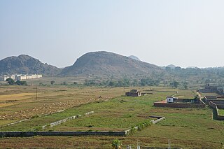
The Chota Nagpur Plateau is a plateau in eastern India, which covers much of Jharkhand state as well as adjacent parts of Chhattisgarh, Odisha, West Bengal and Bihar. The Indo-Gangetic plain lies to the north and east of the plateau, and the basin of the Mahanadi river lies to the south. The total area of the Chota Nagpur Plateau is approximately 65,000 square kilometres (25,000 sq mi).

Jemima Rebecca Redgrave, known as Jemma Redgrave, is a British actress, and a member of the Redgrave family. She played the title character in four series of Bramwell, and has a recurring role in Doctor Who as Kate Stewart, Head of Scientific Research at UNIT. As well as a career in television, she has appeared in many stage productions and on film, including her portrayal of Evie Wilcox in the Merchant Ivory film Howards End.
Cut Knife is a town located in the Canadian province of Saskatchewan on Highway 40, northwest of Saskatoon and 55 km west of North Battleford. The population of Cut Knife in 2011 was 517.
Parthenay is an ancient fortified town and commune in the Deux-Sèvres department of the Nouvelle-Aquitaine region in western France. It is sited on a rocky spur that is surrounded on two sides by the River Thouet, and is the sub-prefecture of the Parthenay arrondissement.
Highway 16 is a provincial highway in the Canadian province of Saskatchewan. It is the Saskatchewan section of the Yellowhead Highway, and also the Trans-Canada Highway Yellowhead section. The main purpose of this highway is to connect Saskatchewan with Canadian cities such as Edmonton and Winnipeg. The highway runs from the Alberta boundary in Lloydminster to the Manitoba boundary near Marchwell. Major cities it passes through are Saskatoon, North Battleford in the central part of the province, Yorkton in the far east and Lloydminster to the far west.

The Northern Woods and Water Route is a 2,400-kilometre (1,500 mi) route through northern British Columbia, Alberta, Saskatchewan and Manitoba in Western Canada. As early as the 1950s, community groups came together to establish a northern travel route; this was proposed as the Northern Yellowhead Transportation Route. The Northern Woods and Water Route Association was established in 1974, and encouraged promotion of the route with the promise of an increase in tourist travel. The route was designated in 1974 and is well signed throughout its component highways. The route starts at Dawson Creek as the Spirit River Highway and ends at the Perimeter of Winnipeg, Manitoba, after running through the northern regions of the western provinces. From west to east, the Northern Woods and Water Route (NWWR) incorporates portions of British Columbia Highway 49; Alberta Highways 49, 2A, 2, & 55; Saskatchewan Highways 55 & 9; Manitoba Provincial Road 283 and Trunk Highways 10, 5, 68 & 6. The halfway point of the NWWR is approximately at Goodsoil, Saskatchewan.

The R747 road is a regional road in Ireland running north-west/south-east from the M9 near Ballitore in County Kildare to Arklow in County Wicklow, a distance of 66 km (41 mi).
Kiyawa is a town and Local Government Area in Jigawa State, Nigeria.

Gardiner is a town in the south-central part of Ulster County, New York, United States. The population was 5,610 at the 2020 census.
| | This Bauchi State, Nigeria location article is a stub. You can help Wikipedia by expanding it. |