
The Fraser Canyon is a major landform of the Fraser River where it descends rapidly through narrow rock gorges in the Coast Mountains en route from the Interior Plateau of British Columbia to the Fraser Valley. Colloquially, the term "Fraser Canyon" is often used to include the Thompson Canyon from Lytton to Ashcroft, since they form the same highway route which most people are familiar with, although it is actually reckoned to begin above Williams Lake at Soda Creek Canyon near the town of the same name.

The Marble Range is a small mountain range adjoining the Fraser River on the southwestern edge of the Interior Plateau of British Columbia. It has an area of 1,250 square kilometres and about 65 km NNW to SSE and about 20 km wide. Its southern flank is the north wall of Marble Canyon and the valley occupied by the ranching and First Nations community of Pavilion.
Downing Provincial Park is a provincial park in British Columbia, Canada, created when Mr. and Mrs. Clair Downing donated their half-mile of lake frontage property on Kelly Lake. The park's size, including the 97 acres (0.39 km2) donated by the Downings, is 156 hectares. It is located adjacent to the British Columbia Railway line and the Pavilion Mountain Road about 30 km west of Clinton, at the junction with the road to Jesmond and Kostering.
Edge Hills Provincial Park is a provincial park in British Columbia, Canada, located west of the town of Clinton. The Edge Hills flank the wall of the Fraser Canyon north of Moran Canyon and form a small fore-range between the river and the higher Marble Range just east. Access to the Edge Hills is via the Jesmond Road, which cuts north off the Pavilion Mountain Road at Kelly Lake. A spur road from the Jesmond Road west goes to an overlook atop the Edge Hills, known as Cougar Point.

Fossli Provincial Park is a provincial park in British Columbia, Canada, located on Stirling Arm of Sproat Lake on Vancouver Island. The 52-hectare park, west of Port Alberni, is accessible by water or private logging road. It has few services, but has a 30-minute hiking trail to an old homestead site. The homestead belonged to Helen and Armour Ford, who donated the land for the park to the province in 1974. Saint Andrew's Creek runs through the park, and is a fall spawning ground for coho salmon.
Marble Range Provincial Park is a provincial park in British Columbia, Canada, located west of 100 Mile House and Clinton at the southwest edge of the Cariboo Plateau along the eastern edge of the Fraser Canyon south from Big Bar-Kostering and near Jesmond.

Clinton is a village in British Columbia, Canada, located approximately 40 km (25 mi) northwest of Cache Creek and 30 km south of 70 Mile House.
Kemano was a settlement situated 75 km (47 mi) southeast of Kitimat in the province of British Columbia in Canada. It was built to service a hydroelectric power station, built to provide energy for Alcan to smelt aluminum from its ore. The Kemano Generating Station is built 427 m (1,400 ft) inside the base of Mt Dubose in a blasted cavern. It produces 896 MW of power from its eight generators, each of which has a capacity of 112MW.
The Williams Lake First Nation is a First Nations government of the Secwepemc (Shuswap) Nation, located in the Cariboo region of the Central Interior region of the Canadian province of British Columbia, at the city of Williams Lake. It was created when the government of the then-Colony of British Columbia established an Indian reserve system in the 1860s. It is a member government of the Northern Shuswap Tribal Council. Its main Indian Reserve is Williams Lake Indian Reserve No. 1, a.k.a. "Sugarcane" or "The Cane" or "SCB".

The Stswecem'c Xgat'tem First Nation, formerly known as Canoe Creek Band/Dog Creek Indian Band, created as a result of merger of the Canoe Creek Band and Dog Creek Band is a First Nations government of the Secwepemc (Shuswap) Nation, located in the Fraser Canyon-Cariboo region of the Central Interior of the Canadian province of British Columbia. It was created when the government of the then-Colony of British Columbia established an Indian reserve system in the 1860s. It is a member government of the Northern Shuswap Tribal Council.
The High Bar First Nation is a First Nations government of the Secwepemc (Shuswap) Nation, located in the Fraser Canyon-Cariboo region of the Central Interior of the Canadian province of British Columbia. It was created when the government of the then-Colony of British Columbia established an Indian reserve system in the 1860s. It is one of three Secwepemc bands that is not a member of either the Shuswap Nation Tribal Council or the Northern Shuswap Tribal Council. The High Bar people are also partly Tsilhqot'in and have links with some Chilcotin First Nations.
The Red Bluff First Nation is a Dakelh First Nations government located in the northern Fraser Canyon region of the Canadian province of British Columbia. It is a member of the Carrier-Chilcotin Tribal Council, which includes both Tsilhqot'in and Carrier (Dakelh) communities.
The Tlʼetinqox-tʼin Government Office is a First Nations government located in the Chilcotin District in the western Central Interior region of the Canadian province of British Columbia. Governing a reserve communities near Alexis Creek known as Anaham Reserve First Nations or Anaham, it is a member of the Tsilhqotʼin Tribal Council aka known as the Tsilhqotʼin National Government. The main reserve is officially known as Anahim's Flat No. 1, and is more commonly as Anaham. Other reserves are Anahim's Meadow No. 2 and 2A, and Anahim Indian Reserves Nos. 3 through 18. Anaham, or Anahim and Alexis were chiefs of the Tsilhqotʼin during the Chilcotin War of 1864, although they and their people did not take part in the hostilities.
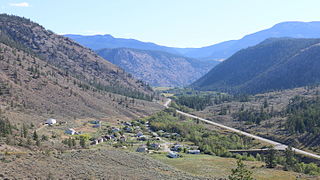
Pavilion is an unincorporated community on the eastern side of the Fraser River in the South Cariboo region of southwestern British Columbia. The place is near Mile 21 of the Old Cariboo Road. On BC Highway 99, the locality is by road about 36 kilometres (22 mi) northeast of Lillooet and 135 kilometres (84 mi) west of Kamloops.

Big Bar Ferry is a cable ferry across the Fraser River in British Columbia, Canada. It is located about 60 kilometres (37 mi) north of the town of Lillooet and 72 kilometres (45 mi) west of Clinton. 6 km upstream from the ferry is French Bar Canyon, while downstream is High Bar Canyon . The ferry connects the dirt ranch road up the west side of the Fraser from Lillooet to Big Bar and Kostering, which connect via road to Jesmond and Big Bar Lake, and beyond to BC Highway 97.
The Poets Estate is a residential area of Hitchin, Hertfordshire, England. It lies to the east of the town centre, based around St Michael's Road and the surrounding roads, which are named after famous British poets. There is a primary school and a community centre called St Michael's Mount.

French Bar Canyon is a canyon on the Fraser River in British Columbia, Canada, near Big Bar and Jesmond, and approximately 60 km upstream from Lillooet.
Troll Ski Resort, often referred to simply as Troll, is a ski area located in the Quesnel Highland in the northeastern Cariboo region of British Columbia, Canada, located between Quesnel and the historic goldfield towns of Wells-Barkerville. The official name of the locality where Troll is located is Pinegrove, British Columbia, which is located between Coldspring House (SW) and Beaver Pass House (NE) on the Barkerville Highway).
The Sq'éwlets First Nation (Scowlitz) is the band government of Skaulits subgroup of the Stó:lō people located on Harrison Bay in the Upper Fraser Valley region between Chehalis (E) and Lake Errock, British Columbia, Canada (W). They are a member government of the Stó:lō Tribal Council.
The Lillooet Land District is one of the 59 cadastral subdivisions of British Columbia, which were created by the Lands Act of the Colony of British Columbia in 1859, defined as "a territorial division with legally defined boundaries for administrative purposes". The land district's boundaries came to be used as the boundary of the initial Lillooet riding for the provincial Legislature from 1871, when the colony became a province. In addition to use in descriptions of land titles and lot surveys, the Land District was also the basis of the Lillooet Mining District.